
RUTA CIRCULAR DE LA RAMBLA SALADA DE ALBATERA
Esta serie de 32 cachés tiene por objetivo realizar una ruta circular de montaña lo largo de parte de la Sierra de Crevillente, recorriendo en primer lugar la llamada Rambla Salada y sus espectaculares formaciones así como las pozas de agua y regresando por la Rambla de las Ventanas hasta el punto de origen, en un recorrido de aproximadamente 12 km. Se trata de una zona muy espectacular y de un paisaje único en la zona. La ruta puede realizarse de forma circular pero para las personas que no estén acostumbradas al paso de ferratas y vías dotadas de cable, se recomienda llegar exclusivamente al CACHÉ Nº 17 y regresar por el mismo camino. Si se desea hacer el resto de cachés sin tener que usar las ferratas, pueden hacerse posteriormente desde el punto de parking en sentido inverso, comenzando por Nº 32.
ATENCION: Se trata de un recorrido de dificultad media-alta, físicamente y técnicamente exigente y que requiere tener experiencia en la montaña, así como el equipamiento adecuado. Es recomendable, aunque no imprescindible arnés para el tramo comprendido entre los CACHÉS Nº 17 a 19.NO ES APTA EN ESE TRAMO para menores de 12 años o personas con vértigo o movilidad reducida. En estos casos, se recomienda llegar exclusivamente al CACHÉ Nº 17 y regresar por el mismo camino. Si se desea hacer el resto de cachés sin tener que usar las ferratas, pueden hacerse posteriormente desde el punto de parking en sentido inverso, comenzando por Nº 32.
LA RAMBLA SALADA DE ALBATERA

La rambla salada discurre en dirección aproximada norte-sur a través de la Sierra de Crevillente, alineación montañosa de la provincia de Alicante (España). Se extiende de suroeste a nordeste entre el río Vinalopó y la Sierra de Abanilla, por los términos de Crevillente, Hondón de las Nieves, Hondón de los Frailes, Albatera y Aspe. Tiene una longitud de 12 kms, por una anchura de 3, oscilando entre los 835 metros sobre el nivel del mar como máxima altura (La Vella) y los 290 de mínima.
Toda la Sierra de Crevillente es un ejemplo típico de geología, morfología y climatología de las sierras que jalonan el sureste peninsular, no muy elevadas, con un clima extremo, de pluviosidad escasa e irregular, con importantes lluvias ocasionales que provocan importantes riadas en las ramblas, frío en los cada vez más escasos meses de invierno y fuertes calores en verano.

Desde el punto de vista orográfico, todo el conjunto de la sierra tiene notables barrancos, rieras, ramblas y pendientes, estando constituida principalmente por calizas blancas y jurásicas, abundando arcillas y yesos de las facies Keuper del Trías superior. Existe una gran riqueza litológica con estructuras y formas de gran valor geológico, lo que da lugar a diferentes ecosistemas; uno de ellos es la Rambla Salada. Por su altísimo interés geológico, se incluye dentro de esta serie un Earth caché donde se explica de forma más detallada la compleja geología del lugar así como el proceso de formación de este rio salado
En ella hay depósitos de sal formados por precipitación al evaporarse el agua en los periodos secos. La filtración del agua de lluvia a través de las fracturas existentes en las rocas, da lugar a aguas subterráneas que disuelven y arrastran la sal existente en los materiales de base impermeables saliendo al exterior mediante surgencias de agua salada que vierten a la rambla. El agua salada circula por la rambla oxidando materiales y aportando sal a la misma, sal que precipita en periodos secos a lo largo del cauce y que marca los niveles de máximo caudal. La presencia de sal impide el uso agrícola y la potabilidad de estas aguas naturales, por lo que los habitantes de la zona tuvieron que ingeniar sistemas para evitar que el agua dulce aportada desde la cabecera de la cuenca se mezclara con el agua salada de las surgencias existentes más abajo.

Respecto a la vegetación, obviamente se encuentra en extremo condicionada por la sal, componente fundamental en el manantial que la recorre. Así, la vegetación corresponde a una maquia de pequeños arbustos y matas herbáceas, de hojas duras, asiduamente espinosas: pino, olivo, algarrobo, romero, rabo de gato o tomillo; es decir, asociaciones vegetales termófilas.
Su valor e interés paisajístico y medioambiental es por todo ello enorme. Los acueductos y canalizaciones, la arquitectura del agua, nos permiten conocer cómo el hombre, desde siempre ha intentado recopilar y almacenar agua para sus diferentes usos, sobre todo, en estas zonas semiáridas y con escasas precipitaciones. La variabilidad mineral y la erosión por la circulación de aguas torrenciales, entre encañonamientos y meandros hacen de la Rambla Salada un entorno único. Caminar por el cauce y la rambla con el lecho blanco de sal es realmente bello. Las surgencias de agua, repletas de sal, brotan por el contacto de materiales impermeables (arcillas, sales y yesos) con otros permeables (areniscas y calizas).

LA RUTA
Como ya he dicho, existen varias posibilidades de llevar a cabo esta ruta, en función del grado de aptitud física y técnica de quien la realiza y del equipamiento que se disponga. Aquí se propone una Ruta Circular de aproximadamente 12 km que recorra en sentido ascendente la Rampla Salada y descienda en el camino de regreso por la llamada Rambla de las Ventanas, por las espectaculares formaciones huecas en la roca, y el Barranco del Ajuero, que nos devuelve al punto de partida.
Comenzamos la ruta en una explanada del Camino de la Sal cerca del barranco del Ajuero. Para llegar a la zona de inicio se accede por la carretera CV-873 durante unos 4,5 km hasta llegar al canal de riego. En ese punto giraremos a la izquierda (existe una señal de Prohibido excepto servicios), pero se puede pasar sin problema, solo tendremos que llevar cuidado con los sobresaltos existentes en esta carretera, ¡son inmensos! Circularemos por esta carretera la cual va paralela a un canal durante 1.9km donde giraremos a la derecha. El camino de la Sal es el quinto camino a mano derecha desde el cruce de la carretera con el canal. Una vez hemos girado, hay que seguir esta carretera (unos 3km) todo recto hasta llegar a un pequeño descampado de tierra donde dejaremos el coche y comenzaremos la ruta. La zona de parking está señalizada en los diferentes cachés como Waypoint.

Desde la explanada donde hemos dejado el coche seguimos la pista de la izquierda, en bajada. La pista discurre junto al barranco del Ajuero, dejando a la derecha la sierra del Cuchillo, en la que se aprecian numerosos agujeros formados por la erosión y que le dan el nombre de "Las Ventanas" a esta zona. Nos desviamos del cauce del barranco del Ajuero por una pista a la derecha. En el siguiente cruce giramos a la derecha y, unos 100 metros más adelante, a la izquierda. Seguimos el trazado de un antiguo acueducto del que todavía quedan varios de los puentes que cruzan los barrancos. Seguiremos el trazado del acueducto unos 300 metros, y nos desviaremos por la izquierda, en bajada, hasta el cauce de la Rambla Salada. En este tramo nos encontramos los cachés nº 1 a 7 de la ruta y su dificultad es baja.

Al llegar a la rambla, continuamos por la derecha. Vamos a pasar por una primera zona conocida como Los Lagos, donde el agua se embalsa. Hay bonitos ejemplos de rocas detríticas (conglomerados) y fósiles de organismos marinos en esta zona. Después pasamos por una zona más estrecha del cauce donde debemos trepar un poco. Cadenas y asideros artificiales nos ayudan a progresar. Más adelante volvemos a salir a una zona más ancha, donde podremos ver los característicos depósitos de sal de la rambla, que contrasta con el color rojizo del cauce, producido por oxidación. En este tramo encontramos los cachés nº 8 a 10 de la ruta, incluyendo el Earth Caché así como otro caché ya existente con anterioridad y que aunque no forma parte de la ruta podemos buscar también dado que se encuentra dentro de la misma.

Tras los depósitos de sal entramos en una zona encajonada donde vamos a ver estratos de color oscuro (Barrón Negro), que son dolomías del triásico, y también estratos de yesos de varios colores. En este tramo encontraremos una enorme pared de roca oscura con una cadena, este tramo es muy interesante y pone a prueba la concentración. En esta zona encontramos el caché nº 11 de la ruta.
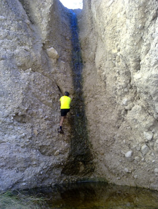
Tras superar esta pared negra tan peculiar vemos varios restos: la casa del minero y antiguos pozos. La rambla se abre y seguimos caminando por ella hasta llegar al tramo equipado con grapas, cuya primera y mayor dificultad será la primera pared que nos encontramos, de 15 metros de altura (muy recomendable material (kit ferrata o cuerda). En este tramo se encuentran los cachés nº 12 a 17 de la ruta. Como se ha dicho al principio, desde este punto, la ruta requiere tener experiencia en la montaña, así como el equipamiento adecuado. Es recomendable, aunque no imprescindible arnés para el tramo comprendido entre los CACHÉS Nº 17 a 19. NO ES APTA EN ESE TRAMO para menores de 12 años o personas con vértigo o movilidad reducida. En estos casos, se recomienda llegar exclusivamente al CACHÉ Nº 17 y regresar por el mismo camino. Si se desea hacer el resto de cachés sin tener que usar las ferratas, pueden hacerse posteriormente desde el punto de parking en sentido inverso, comenzando por Nº 32.

Tras éste hay otro "lago" con pasos laterales equipados con grapas. Continuamos y encontramos una bifurcación: a la izquierda la salida fácil y a la derecha un poco más complicada, pero no de gran dificultad, que es la que tomamos. Está indicada como Variante II. Pasamos por una charca con subida de tres metros, equipada con una cadena y al final otra última charca con subida vertical de 7 metros, también equipada con alguna grapa y cable de vida. Los pasos son entretenidos pero no difíciles, se hace muy divertida. En este tramo encontramos los cachés nº 18 y 19.

Salimos de la rambla, seguimos la pista y encontramos los cachés nº 20 y 21, pero enseguida nos desviamos a la izquierda. Es posible seguir directamente el camino asfaltado, pero he preferido esta variante, que es algo más complicada y apenas tiene señalización, pero es mucho más interesante que la pista. Desde la pista asfaltada se baja por la izquierda, hasta el Barranco del Ajuero y se continúa por el cauce pasando una primera presa para bajar a la rambla, por la que entramos rodeando una presa. OJO!! Al llegar a un cañaveral que impide el paso se continúa por la izquierda, hasta otra presa. Debemos prestar atención cuando la senda se desvía a la izquierda, pues la tendencia es continuar de frente, pero llegamos a un salto del barranco que no se puede descender. Hay que subir a la parte superior de la presa y localizar un sendero que rodea la falda oeste del Monte Alto. Por este sendero bien definido se sale a una pista de tierra que confluye con el camino de las Ventanas para regresar al punto de partida. Aquí nos encontraremos los cachés nº 22 a 32 y último de la serie.
Se trata en definitiva de una ruta diferente, que muestra el avance de la desertización en el sur de Alicante, pero con algunas perlas escondidas como esta rambla salada.
FICHA TECNICA DE LA RUTA

- Actividad: Ruta de Media Montaña con trepadas, ferratas y cordadas
- Sierra: Sierra de Crevillente
- Posición Geológica Regional: Cordilleras Béticas - Zonas Externas - Prebético
- Comarca: Vega Baja del Segura, Alicante
- Distancia: 11.7 km
- Punto de Partida: Camino de la sal. Zona de Parking.
- Punto de Llegada: Camino de la sal. Zona de Parking.
- Circular: Si
- Desnivel superado: Inicial 290m. máximo 487 m.
- Caminos Homologados: No
- Itinerario: Cartel de la Consellería / Bancal de olivos / Acueductos / Ladera sur Cuchillo de las ventanas / Rambla Salada / Barrón negro / Desfiladero / Zona de los 4 saltos (vía ferrata) / Salida del barranco / Pista de tierra / Pista de las ventanas / Cruce con el pr-cv 180 / Cartel de la Consellería.
- Calificación Técnica: Media - Alta. Los tramos de trapadas y ferratas requieren conocimiento y cuidado especial.
- Calificación de exigencia Física: Media - Alta.
- Recomendaciones: Esta ruta y en general el senderismo de montaña requiere una adecuada preparación física, una buena planificación previa de la ruta en el sentido de conocer a donde se va y por donde, una buena reserva alimentaría y liquida (no confiarse nunca en que nos podamos encontrar fuentes) y desde luego ir provisto del material adecuado (prendas, calzado…). E incluso aspectos tales como la meteorología y el saber seleccionar la ruta según la época del año son importantes tenerlos en cuenta a la hora de acometer una ruta de montaña de manera segura y por ende satisfactoria.
LOS CACHÉS
Se trata de UNA SERIE DE 32 CACHÉS, 31 de ellos idénticos, formato tupper, tamaño pequeño, unos 14 x 9 x 5 cm, en cuyo interior encontramos una LIBRETA para logs, FOLLETO EXPLICATIVO de en qué consiste en geocaching, Bolígrafo y algún pequeño REGALO. Inicialmente en el caché nº 18 se deposita TRAVEL BUG para ser movido a otros cachés. Todo el contenido se encuentra protegido por bolsa de cierre hermético.POR FAVOR, UTILIZAR EL MINIMO ESPACIO POSIBLE DE LA LIBRETA PARA LOS LOGS, de esta forma durará más. Es muy importante volver a dejarlo tal como se encontró. En todos los listing hay FOTOS SPOILER correspondientes a cada uno de ellos. Además de ello se incluye un EARTH CACHÉ alusivo a la formación de corrientes saladas en interior.


Gracias y FELIZ BUSQUEDA!!


SORRY ABOUT THE POOR TRANSLATION. IT WAS GOOGLE.
CIRCULAR TRAIL IN RAMBLA SALADA, ALBATERA
This series of 32 cachés aims to make a circular mountain route along part of the Sierra de Crevillente, first crossing the Rambla Salada and its spectacular formations as well as the pools of water and returning along the Rambla de las Ventanas To the point of origin, in a course of approximately 12 km. It is a very spectacular area and a unique landscape in the area. The route can be done in a circular way but for people who are not accustomed to the passage of ferratas and cableways, it is recommended to arrive exclusively to CACHÉ Nº 17 and return by the same road. If you want to do the rest of the caches without having to use the ferratas, they can be done later from the parking point in reverse, starting with Nº. 32.
ATTENTION: This is a course of medium-high difficulty, physically and technically demanding and requires experience in the mountains, as well as adequate equipment. It is advisable, although not essential harness for the section between CACHÉS Nº 17 to 19. NOT ENJOY IN THAT DEPARTMENT for children under 12 years or people with vertigo or reduced mobility. In these cases, it is recommended to arrive exclusively at CACHÉ Nº 17 and return by the same road. If you want to do the rest of the caches without having to use the ferratas, they can be done later from the parking point in reverse, starting with No. 32.
RAMBLA SALADA IN ALBATERA
The Rambla Salada runs in an approximate north-south direction through the Sierra de Crevillente, mountainous alignment of the province of Alicante (Spain). It extends from southwest to northeast between the Vinalopó River and the Sierra de Abanilla, by the terms of Crevillente, Hondón de las Nieves, Hondón de los Frailes, Albatera and Aspe. It has a length of 12 kms, by a width of 3, oscillating between 835 meters above sea level as maximum height (La Vella) and 290 minimum.
The Sierra de Crevillente is a typical example of geology, morphology and climatology of the sierras that line the peninsular southeast, not very high, with an extreme climate, of scarce and irregular rainfall, with important occasional rains that provoke important floods in the ramblas , Cold in the increasingly scarce months of winter and hot heats in summer.
From the orographic point of view, the whole mountain range has remarkable ravines, rieras, ramblas and slopes, being mainly constituted by white and Jurassic limestones, abundant clays and gypsum of the facies Keuper of the upper Trías. There is a great lithological wealth with structures and forms of great geological value, which gives rise to different ecosystems; One of them is the Rambla Salada. Due to its high geological interest, an Earth Cache is included in this series, which explains in more detail the complex geology of the place as well as the process of formation of this salty river
There are salt deposits formed by precipitation as the water evaporates in the dry periods. The filtration of rainwater through the fractures in the rocks gives rise to groundwater that dissolves and drags the existing salt in the impermeable base materials exiting the outside by means of salty water spouts that pour into the rambla. The salt water circulates through the rambla oxidizing materials and contributing salt to it, salt that precipitates in dry periods along the channel and that marks the levels of maximum flow. The presence of salt prevents the agricultural use and potability of these natural waters, so that the inhabitants of the area had to devise systems to prevent the fresh water supplied from the head of the basin to mix with the salty water of the upwellings Existing below.
With regard to vegetation, it is obviously extremely conditioned by salt, a fundamental component in the spring that flows through it. Thus, the vegetation corresponds to a shrub of small shrubs and herbaceous plants, with hard leaves, assiduously thorny: pine, olive, carob, rosemary, cat's tail or thyme; That is, thermophilic plant associations.
Its value and landscape and environmental interest is therefore enormous. The aqueducts and canalizations, the architecture of water, allow us to know how man has always tried to collect and store water for its different uses, especially in these semi-arid areas and with little rainfall. The mineral variability and the erosion caused by the circulation of torrential waters, between girders and meanders make the Rambla Salada a unique environment. Walking along the channel and the rambla with the white bed of salt is really beautiful. The emergence of water, full of salt, comes from the contact of impermeable materials (clays, salts and gypsum) with other permeables (sandstones and limestones).
THE ROUTE
As I said, there are several possibilities to carry out this route, depending on the degree of physical and technical fitness of the person doing it and the equipment available. Here we propose a Circular Route of approximately 9 km that travels upstream the Rambla Salada and descend on the way back through the Rambla de las Ventanas, for the spectacular hollow formations in the rock, and the Barranco del Ajuero, which Returns to the starting point.
We begin the route in an esplanade of the Way of the Salt near the ravine of the Ajuero. To get to the starting area is accessed by the CV-873 for about 4.5 km until you reach the irrigation channel. At that point we will turn left (there is a sign of Prohibited except services), but you can pass without problem, we only have to be careful with the shocks that exist on this road, they are immense! We will drive along this road which runs parallel to a canal for 1.9km where we turn right. The Sal road is the fifth road on the right hand side from the junction of the road with the canal. Once we have turned, we must follow this road (about 3km) straight ahead until we reach a small dirt field where we will leave the car and begin the route. The parking area is signposted in different caches as Waypoint.
From the esplanade where we left the car we follow the track to the left, downhill. The trail runs along the Ajuero ravine, leaving to the right the Cuchillo mountain range, where there are numerous holes formed by erosion and which give the name "Las Ventanas" to this area. We deviate from the channel of the Ajuero ravine by a track on the right. At the next junction turn right and, about 100 meters ahead, to the left. We follow the route of an old aqueduct of which there are still several of the bridges that cross the ravines. We will follow the path of the aqueduct about 300 meters, and we will turn left, downhill, to the bed of the Rambla Salada. In this section we find the caches nº 1 to 7 of the route and its difficulty is low.
When you reach the rambla, continue on the right. We will pass through a first zone known as Los Lagos, where the water is impaled. There are beautiful examples of detrital rocks (conglomerates) and fossils of marine organisms in this area. Then we go through a narrow area of the channel where we must climb a little. Artificial chains and handles help us to progress. Later on, we return to a wider area, where we can see the characteristic salt deposits of the rambla, which contrasts with the reddish color of the channel, produced by oxidation. In this section we find the caches 8 to 10 of the route, including the Earth Caché as well as another cache already existing before and that although it is not part of the route we can also search since it is within the same.
After the salt deposits we enter a boxed area where we will see layers of dark color (Black Barron), which are Triassic dolomites, and also strata of plasters of various colors. In this section we will find a huge dark rock wall with a chain, this section is very interesting and tests the concentration. In this area we find the cache nº 11 of the route.
After surpassing this black wall so peculiar we see several remains: the house of the miner and old wells. The rambla opens and we continue walking until reaching the section with staples, whose first and greatest difficulty will be the first wall that we are, 15 meters high (highly recommended material (kit ferrata or rope). As mentioned at the beginning, from this point, the route requires mountain experience, as well as adequate equipment. It is advisable, although not essential, for the section between the CACHÉS Nº 17 to 19. It is not suitable for children under 12 years or people with vertigo or reduced mobility, in these cases, it is recommended to arrive exclusively to CACHÉ Nº 17 and to return by the same road. Of caches without having to use the ferratas, can be done later from the point of parking in reverse, starting with No. 32.
Behind this is another "lake" with side steps fitted with staples. We continue and we find a bifurcation: to the left the easy exit and to the right a little more complicated, but not of great difficulty, that is the one that we take. It is indicated as Variant II. We passed by a pond with a rise of three meters, equipped with a chain and at the end another pond with vertical rise of 7 meters, also equipped with some staple and cable of life. The steps are entertaining but not difficult, it becomes very fun. In this section we find the cachés nº 18 and 19.
We leave the rambla, we follow the track and we find the cachés nº 20 and 21, but soon we deviate to the left. It is possible to follow directly the asphalted road, but I have preferred this variant, which is somewhat more complicated and has little signage, but is much more interesting than the track. From the asphalted track you go down on the left, until the Barranco del Ajuero and continue along the channel passing a first dam to go down to the promenade, through which we enter surrounding a dam. ATTENTION ¡!! When you reach a canefield that prevents the passage, continue on the left, to another dam. We must pay attention when the path is deviated to the left, as the tendency is to continue straight ahead, but we arrive at a jump of the ravine that can not descend. You have to climb to the top of the dam and locate a path that surrounds the western slope of Monte Alto. Along this well-defined path you will reach a dirt track that converges with the Ventanas road to return to the starting point. Here we will find the caches nº 22 to 32 and last of the series.
It is definitely a different route, which shows the advance of desertification in the south of Alicante, but with some hidden pearls like this salad barbeque.
ROUTE DATA SHEET
- Activity: Middle Mountain Trail climbs, sharp edges and ferratas
- Sierra: Sierra de Crevillente
- Regional Geological -Position: Cordilleras Béticas - External Zones - Prebético
- Comarca: Vega Baja del Segura, Alicante
- Distance: 11.7 k
- Starting -point: Parking zone Camino de la sal
- Point Arrival: Parking zone Camino de la sal
- Circular: Yes
- Desnivel Exceeded: Initial 290m. maximum 487 m.
- Roads Approved: No
- Itinerary: Cartel de la Consellería / Bancal de olivos / Acueductos / Ladera sur Cuchillo de las ventanas / Rambla Salada / Barrón negro / Desfiladero / Zona de los 4 saltos (vía ferrata) / Salida del barranco / Pista de tierra / Pista de las ventanas / Cruce con el pr-cv 180 / Cartel de la Consellería.
- Calificación Technique: Medium - High. Air sections and transit through the edges and knowledge and requires special care.
- Calificación Physical demand: Medium - High.
- Recommendations: This general route and mountain hiking requires adequate physical preparation, a good pre-planning the route in the sense of knowing where you are going and where, good food reserves and liquid (never trusted to we can find sources) and certainly go provided with suitable material (clothes, shoes ...). And even issues such as weather and know how to select the route according to the time of year are important them into account when undertaking a mountain path safely and therefore satisfactory.
THE CACHÉS
It is a SERIE OF 32 CACHES, 31 of them identical, tupper format, small size, about 14 x 9 x 5 cm, inside which we find a booklet for logs, EXPLANATORY BROCHURE of what is geocaching, Ballpoint pen and some small PRESENT. Initially in cache # 18 TRAVEL BUG is deposited to be moved to other caches. All content is protected by a sealed pouch. PLEASE USE THE MINIMUM POSSIBLE SPACE FOR THE LOGS, this way it will last longer. It is very important to leave it as it was found. In all the listings there are PHOTOS SPOILER corresponding to each one of them. In addition, an EARTH CACHÉ is included, alluding to the formation of salty currents in the interior.
Thanks and happy hunting !!