This is candy_tyt’s first cache for celebrating her 30th birthday. (Getting old  ).
).
Have to say there is no logical reason for hiding the cache there – it is just on her way home.
Have to say her hiding skill is too poor so she made a puzzle trying to add up a bit difficulty for the cache.
Stealth may be required depending on time of day.
So the puzzle:
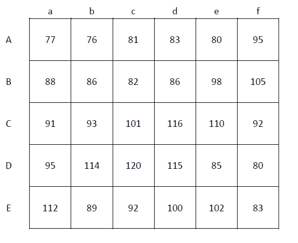
You are given a figure with 6×5 grids with same size stand for same area of land, each grid has a number in it. Considering these numbers are the elevations – larger number means higher and smaller number means lower. When it rains on this area, for each grid cell, there are eight possible flow directions - of course, the water only flows towards downhill. What you need to do is:
(1) Find out the flow pathways arrows. ONLY one flow direction for each cell, based on the STEEPEST downhill slope (the distance between each grid is 1 horizontally and vertically, √2 diagonally. The slope is calculated as the difference of the elevation divided by the distance).
(2) Water will be accumulated at downhill. Supposed that there is one unit of water in each cell, and calculate the accumulated flow of each cell based on the flow direction you found in step (1). For example, if there is no cell which flow into it then the amount of water is 0. And if one cell receives water from three other cells which has 1 unit of water then this cell has 3 unit of water. Calculate the number of unit water accumulated for each cell and replace the original numbers with the calculated numbers. (Hint: accumulate the number of flow arrows).
Followed the instructions above, what you did is basically how a DEM (Digital Elevation Model) works for runoff analysis. A DEM is a digital model or 3D representation of a terrain’s topography based on terrain elevation data. As topography is one of the major factors in runoff analysis, DEMs play an important role in hydrologic studies. DEMs consist of a raster grid of regularly spaced elevation values. DEMs may be obtained in a number of ways, but they are often derived from remote sensing data. (Too much words here but not for the cache, if you are interesting in more information about DEM please see https://en.wikipedia.org/wiki/Digital_elevation_model).
Now you have a table with new numbers in each cell.
Let’s say the number of cells that the water cannot flow to any other cells but out of the grid is M (these cells are called outlets in hydrologic term).
And the final coordinate will be:
S 33°5M. (Ab)(Ab)(De)’
E 151°14. (Bc)(Cc)(Ea)’
PS: BYO pen. The cache has less than 500m from posted coordinates.
You can check your answers for this puzzle on GeoChecker.com.