Teorija
HR
U geologiji, rasjed je ravna ili lagano zakrivljena fraktura nastala na Zemljinoj kori, nastala djelovanjem sila koje uzrokuju pomicanje stijena na suprotnim stranama pukotine. duljina rasjeda varira od nekoliko centimetara do nekoliko stotina kilometara, dok sama razdaljina unutar rasjeda može biti manja od centimetra, ali i šira od nekoliko stotina kilometara duž površine frakture (rasjedna ploha). U nekim slučajevima, pokret se prenosi preko zone rasjeda koja se sastoji od mnogo pojedinačnih rasjeda koji se protežu u širinu od nekoliko stotina metara. Geografski raspored rasjeda varira; na nekim velikim područjima gotovo ih i nema, dok su druga ispresijecana nebrojenim rasjedima.
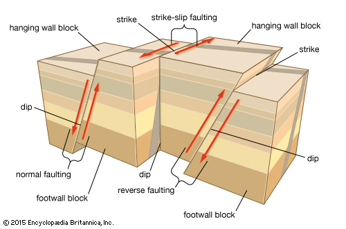
Rasjedi mogu biti vodoravni, okomiti ili kosi. Iako kut specifične rasjedne plohe ima relativno jedinstveni nagib, moguće je da njegova dužina varira ovisno o mjestu. Kad stijene klize jedna uz drugu prilikom rasjeda, gornja stijena rasjedne plohe naziva se krovinskim blokom, dok se donja stijena naziva pozadinskim blokom. Linija rasjeda je smjer linija presjeka između paraklaze i površine Zemlje. Nagib plohe je njezin kut mjeren s obzirom na horizontalu.
Rasjedi se dijele prema relativnom pomaku i prema pružanju rasjedne plohe. Normalni rasjedi nastaju vertikalnom kompresijom koja je rezultat produžavanja Zemljine kore. Krovinski se blok spušta prema pozadinskom. Ovakvi su rasjedi uobičajeni; nalazimo ih uz mnoge planinske lance i mnoge rasjedne doline koje leže uz tektonske ploče. Rasjedne doline nastaju spuštanjem krovinskog bloka nekoliko tisuća metara dok ne postane dolina.
Blok koji se spustio između dva normalna rasjeda koji naginju u suprotnim smjerovima jedan od drugoga naziva se tektonski rov. Blok koji se izdigao između dva normalna rasjeda čiji koji naginju u suprotnim smjerovima jedan od drugoga zove se stršenjak. Nakrivljeni blok koji leži između dva normalna rasjeda položena u istom smjeru naziva se kosi rasjedni blok.
Reversni rasjedi (eng. Reverse dip-slip) rezultat su horizonstalnih kompresijskih sila koje uzrokuje skraćivanje ili kontrakcija Zemljine kore. Krovinski blok se podiže i nadilazi pozadinski. Navlačni rasjed je reversni rasjed čiji nagib je manji od 45°. Navlačni rasjedi s niskim nagibom i velikim ukupnim pomakom nazivaju se navlake; često se nalaze na vrlo deformiranim planinskim lancima.
Pružno-klizni (eng. Strike-slip) (transkurentni ili lateralni) rasjedi nastaju zbog horizontalne kompresije, ali energiju oslobađaju horizontalnim micanjem stijena, gotovo paralelno sili kompresije. Rasjedna ploha gotovo je vertikalna i pomak je lateralni. Ovakvi su rasjedi česti i nerijetko se nalaze na granicama ocanskih i kontinentalnih tektonskih ploča. Dobro je poznat primjer Rasjeda San Andreas koji se, za vrijeme potresa u San Franciscu 1906 pomaknuo za 6 m.
Kosi rasjedi (eng. Oblique-slip) imaju istovremeni pomak gore ili dolje te uzduž linije. Raspored stijena na suprotnim stranama rasjedne plohe mjeri se u odnosu na sedimentne naslage ili druge markere poput nasipa. Pomak duž rasjeda može biti rotacijski, odnosno blokovi se mogu međusobno rotirati. Pomak može zagladiti zidove rasjeda, označavajući ih strijacijama ili ih može smrviti do tvari slične glini, poznatije kao bore. Breccia je vrsta grube smrvljene stijene. Može se dogoditi da se plohe blizu rasjedne plohe saviju zbog trenja. Područja s puno sedimentarnih stijena često ne pokazuju naznake rasjeda u dubini.
Pomak stijena uz rasjed može se javiti kao stalno pomicanje ili u vidu spazmičkih skokova od nekoliko metara tijekom nekoliko sekundi. Takve skokove razdvajaju intervali tijekom kojih pritisak raste dok ne nadiđe silu trenja na rasjednoj plohi što izaziva novi pomak. Većina, odnosno gotovo svi, potresi rezultat su naglih pomaka u rasjedima.
O lokalitetu
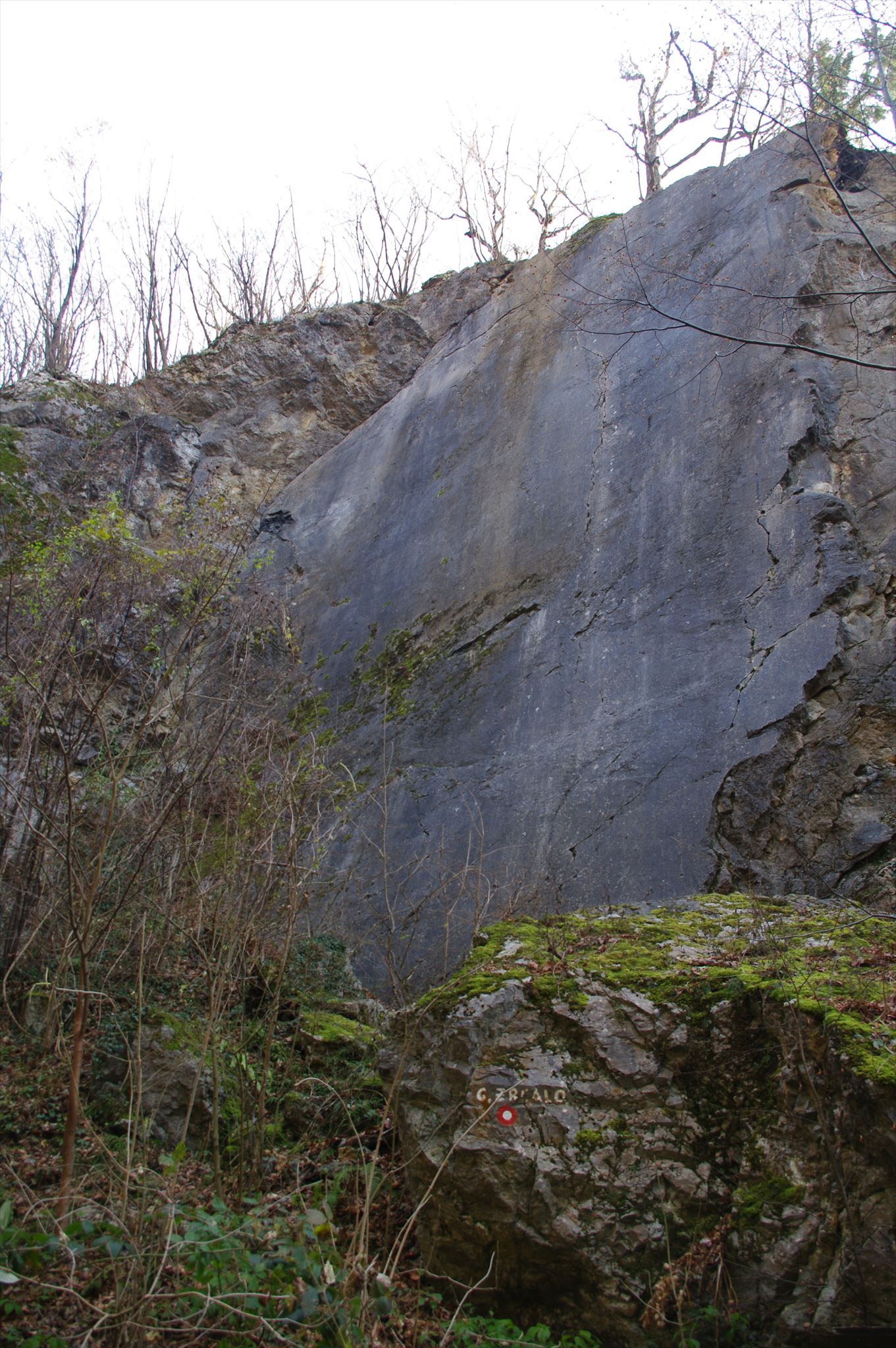
Sada kada znamo teoriju ukratko ćemo se pozabaviti samim lokalitetom. Gorsko zrcalo je jedna od najatraktivnijih prirodnih znamenitosti u Parku prirode Medvednica. To je glatka, otvorena, okomita stijena visoka dvadesetak metara i isto toliko široka, nastala kao rasjedna ploha uzduž tektonske pukotine. Kosi urezi na stijeni ukazuju da se u geološkoj prošlosti stijena duž ovog loma pomicala na desno. Stijena je vapnenac, a izgledom podsjeća na granit. Lokalitet je danas izletište i penjalište.
Ne zaboravi na CITO inicijativu : CITO-iziraj svaki dan ;
 CITO se može provesti na svakoj geokešing avanturi!
Pokupi smeće na putu!
Očisti smeće oko keša
Ti mali koraci čine razliku
Više o inicijativi na : https://www.geocaching.com/cito/
U blizini ovog keša nalazi se kanta za smeće !
Zadatak za logiranje
Kako biste logirali ovaj keš morate odgovoriti na slijedeća pitanja ?
1. Na koju stranu svijeta je okrenuta ravna glatka ploha stijene ?
2. S obzirom na smjer pomicanja stijene koja je to vrsta rasjeda (loma) ?
3. Na lokaciji primjetit ćete uređenu nadstrešnicu sa stolovima. Na desnom stupu s unutarnje strane crvenim slovima upisan je datum 28.3. '15 ispod kojega je napisano pet imena. Koja imena su napisana ?
4. Opcionalno postajte fotografiju sa lokacije (nije obvezno) ?
Odgovore pošaljite na moju e-mail adresu, a NE u Vašem logu! Ne morate čekati na moje potvrđivanje Vaših odgovora. Jednom kada pošaljete Vase odgovore slobodno logirajte pronalazak ovog EarthCachea. Ako Vaši odgovori budu pogrešni ja cu kontaktirati Vas.
Upozorenje !! Ne približavajte se stijeni jer uvijek postoji opasnost od pada kamenja sa vrha.
EN TEORY
Fault, in geology, a planar or gently curved fracture in the rocks of the Earth’s crust, where compressional or tensional forces cause relative displacement of the rocks on the opposite sides of the fracture. Faults range in length from a few centimetres to many hundreds of kilometres, and displacement likewise may range from less than a centimetre to several hundred kilometres along the fracture surface (the fault plane). In some instances, the movement is distributed over a fault zone composed of many individual faults that occupy a belt hundreds of metres wide. The geographic distribution of faults varies; some large areas have almost none, others are cut by innumerable faults.
Faults may be vertical, horizontal, or inclined at any angle. Although the angle of inclination of a specific fault plane tends to be relatively uniform, it may differ considerably along its length from place to place. When rocks slip past each other in faulting, the upper or overlying block along the fault plane is called the hanging wall, or headwall; the block below is called the footwall. The fault strike is the direction of the line of intersection between the fault plane and the surface of the Earth. The dip of a fault plane is its angle of inclination measured from the horizontal.
Faults are classified according to their angle of dip and their relative displacement. Normal dip-slip faults are produced by vertical compression as the Earth’s crust lengthens. The hanging wall slides down relative to the footwall. Normal faults are common; they bound many of the mountain ranges of the world and many of the rift valleys found along spreading margins of tectonic plates. Rift valleys are formed by the sliding of the hanging walls downward many thousands of metres, where they then become the valley floors.
A block that has dropped relatively downward between two normal faults dipping toward each other is called a graben. A block that has been relatively uplifted between two normal faults that dip away from each other is called a horst. A tilted block that lies between two normal faults dipping in the same direction is a tilted fault block.
Reverse dip-slip faults result from horizontal compressional forces caused by a shortening, or contraction, of the Earth’s crust. The hanging wall moves up and over the footwall. Thrust faults are reverse faults that dip less than 45°. Thrust faults with a very low angle of dip and a very large total displacement are called overthrusts or detachments; these are often found in intensely deformed mountain belts.
Strike-slip (also called transcurrent, wrench, or lateral) faults are similarly caused by horizontal compression, but they release their energy by rock displacement in a horizontal direction almost parallel to the compressional force. The fault plane is essentially vertical, and the relative slip is lateral along the plane. These faults are widespread. Many are found at the boundary between obliquely converging oceanic and continental tectonic plates. A well-known terrestrial example is the San Andreas Fault, which, during the San Francisco earthquake of 1906, had a maximum movement of 6 metres (20 feet).
Oblique-slip faults have simultaneous displacement up or down the dip and along the strike. The displacement of the blocks on the opposite sides of the fault plane usually is measured in relation to sedimentary strata or other stratigraphic markers, such as veins and dikes. The movement along a fault may be rotational, with the offset blocks rotating relative to one another.
Fault slip may polish smooth the walls of the fault plane, marking them with striations called slickensides, or it may crush them to a fine-grained, claylike substance known as fault gouge; when the crushed rock is relatively coarse-grained, it is referred to as fault breccia. Occasionally, the beds adjacent to the fault plane fold or bend as they resist slippage because of friction. Areas of deep sedimentary rock cover often show no surface indications of the faulting below.
Movement of rock along a fault may occur as a continuous creep or as a series of spasmodic jumps of a few metres during a few seconds. Such jumps are separated by intervals during which stress builds up until it overcomes the frictional forces along the fault plane and causes another slip. Most, if not all, earthquakes are caused by rapid slip along faults.
About locality
Now that we know the theory, we shall take a look at the locality. The mountain mirror is one of the most attractive natural sights in the Medvednica park. It is smooth, open, vertical cliff twenty meters high and as many wide, created as a fault plane along a tectonic crack. Notches on the rock indicate that in its geological past, the rock moved to the right. The rock is limestone, and looks like a granite. The site is today used for excursions and climbing.
Dont forget about CITO Initiative : CITO every day ;
CITO can happen on every geocaching adventure!
Pick up trash that you see on the trail.
Clean up the area around each geocache.
These small acts make a huge difference.
More info at : https://www.geocaching.com/cito/
Nearby GZ u can find garbbage can
In order to log on to this cache, you need to answer the following:
1. Smooth face of the rock pointed to on which earth side ?
2. What type of fault is it (considering the rock movement) ?
3. On the site you will notice decorated canopy beneath which are tables. On the right column on the inside with red letters written date 28.3. '15, Under which was written five names. Which names are written ?
4. You may post a photo of the location (optional)
Send your answers to my e-mail address and NOT in a log. You don't have to wait for me to approve your answers. Once you send your answers feel free to log the cache as found. If your answers are wrong, I will contact you.
Warning!! Don't approach the cliff as there is danger of rocks falling.
Source :
1. https://www.britannica.com/science/fault-geology#ref93064
2.http://www.stari.pp-medvednica.hr/Staze/track-1-1.html#PhotoSwipe1480491614322
3. Information board on the location