A brief history of Buxton
The area now known as Buxton has a history going back about 7000 years, to the Mesolithic (middle Stone age) period of early man in about 5000BC. Archaeological finds in the Peak District around this settlement show habitation through the Neolithic Bronze and Iron Ages to the time of the Romans.
In Roman times, Buxton was known as Aquae Arnemetia (The waters of the Goddess of the Grove). It was a Roman Spa, situated on the junction of several roads and providing bathing facilities in the warm mineral waters. Evidence indicates that the Romans inhabited Buxton for most of the time they occupied Britain.
Buxton is not mentioned in the Domesday Book, but at the time it was primarily a cattle pasturing area and, in terms of revenue, may not have been of sufficient interest to the King's commissioners.
In about 1100AD, the name of Buckestanes is first recorded, on a foundation charter for land given by William Peveril to found Lenton Abbey in Nottinghamshire.
In the Elizabethan era Buxton enjoyed considerable fame as a spa, and in 1572 Dr John Jones wrote the first medical book on Buxton waters entitled 'The Benefit of the Auncient Bathes of Buckstones'.
By the early 19th century, Buxton still had a population of under one thousand. Facilities were modest, and it could still be described as a village. Hall Bank, built largely in the 1790s, provided lodging houses and the Square, built in 1806, offered more substantial town houses.
From 1850 Buxton began to grow into a busy and fashionable spa. The shaping of the town was greatly influenced by a small number of people, including the 6th and 7th Dukes of Devonshire, and Dr. W. H. Robertson, who was a longtime Chairman of the Devonshire Hospital Charity and author of the extremely popular 'Handbook to the Peak of Derbyshire'.
Much of the resulting Victorian/Edwardian buildings can still be seen on a walk around the town today.
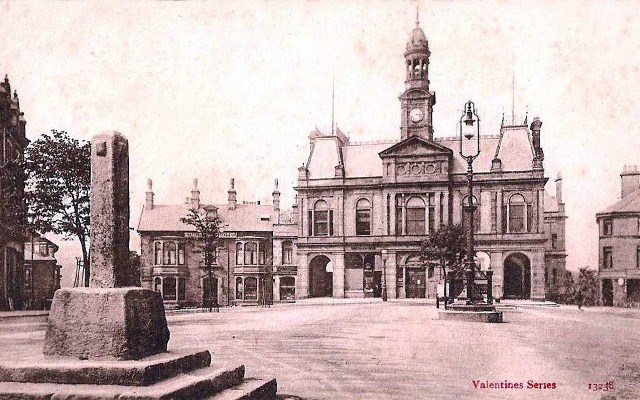
Given co-ordinates: The Market Place and Town Hall
The Market Place was the historic core of the town at least as early as the medieval period, although the town only had a market charter officially granted in 1813.
Within the market place stand two small structures; the market cross and the fountain (or more accurately well-head). The market cross was brought into Buxton from another location north of the River Wye (on the route out towards Manchester) and it is thought to be a wayside cross. It has changed position several times, including in 1813 to mark the Royal Charter being awarded to Buxton Market.
The well-head was constructed in association with the provision of a piped water supply to Higher Buxton by the Duke of Devonshire in 1840. This was served by a reservoir on Manchester Road. The well-head has been eroded and the date and carving are no longer legible.
The north end of the market place is dominated by the Town Hall, built in 1889. The building replaced the 1857 market hall, which burnt down in a fire.
Task: At the given co-ordinates, there is an information board. When was the earliest map of Buxton? This is ABCD. (TEMPORARILY UNAVAILABLE - therefore not used in the current formula to work out the co-ords)

Waypoint 1 (optional): St. Anne's Church
The origins of St. Anne's Church are uncertain. There is a date of 1625 carved on the church porch, but parts of the building are thought to be older. John Wesley is said to have preached in the church when on a visit to Buxton.
An earlier chapel dedicated to St. Anne once stood on St. Anne's Cliff (now known as The Slopes), but this was closed in 1538 by Sir William Bassett of Langley during the Reformation.
When the present building was built, having moved location to the top of Bath Road, it was dedicated to St. John for a short while, before reverting to St. Anne's.
After the parish church of St. John the Baptist was built in Buxton in 1811, St. Anne's was converted to a school, then later a Sunday School, a mortuary chapel, and then closed.
In 1885 the church was restored for divine service and re-dedicated to St. Anne.
Waypoint 1 task: This stage is optional, and just for information. There are no numbers to gather here, so it can be missed out if you don't want to walk this far.
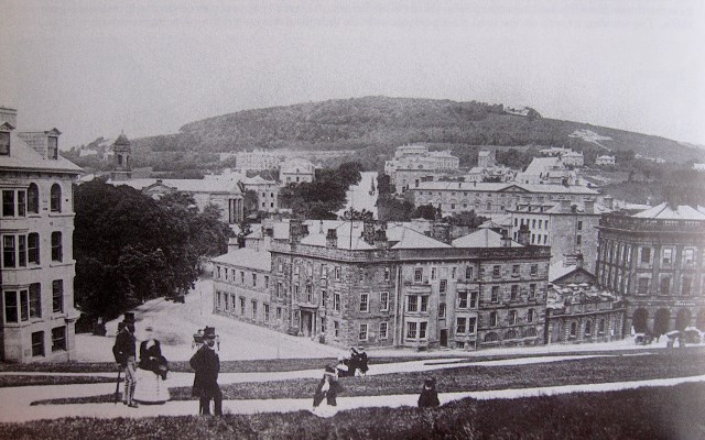
Waypoint 2: The Old Hall Hotel
Although historians believe that a building for travellers may have stood on the site for as long as 3000 years, the present building was built in 1670, around an earlier four-storey fortified tower built in 1573 by the 6th Earl of Shrewsbury, which itself was on the site of an earlier building called the Auld Hall.
Named the New Hall, the 1573 tower was built to provide accommodation for Mary Queen of Scots, who was under house arrest at the time (in the custody of the Earl and Countess). She was housed in the tower at various times between 1576 and 1578, with the last time she visited Buxton being in 1584.
The Countess - better known as 'Bess of Hardwick' - also gave us Hardwick Hall and Chatsworth House. The children from her first marriage to Sir William Cavendish created the line of the Dukes of Devonshire.
When the Duke of Devonshire rebuilt the hall in 1670, it was thought that he demolished the Earl of Shrewsbury’s 1573 building, but the 'Royal Commission on Historical Monuments in England' established that the original building still stands behind the facade and extension of the Duke’s building.
By 1727 the Hall had become a hotel, the only one in Buxton at that time. Built on the site of a natural warm spring, the spring is immediately under the eastern end of the hotel.
Waypoint 2 task: To the right of the main door there is a plaque. The number of words in the second line is E, and the number of words in the sixth line is F.
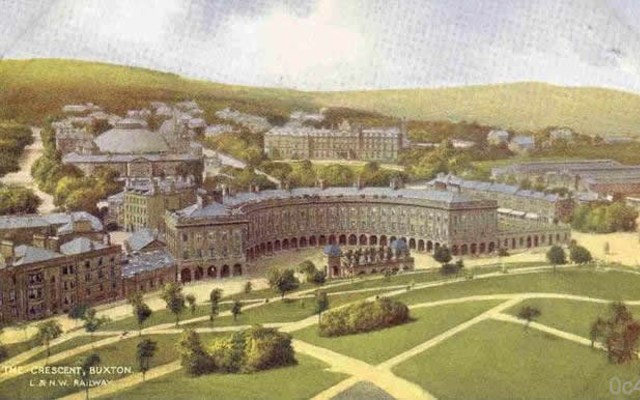
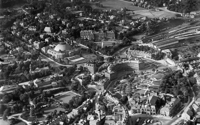
Waypoint 3: The Crescent and St. Ann's Well
In the 18th century, the 5th Duke of Devonshire decided to provide Buxton with greatly enhanced facilities in the shape of the Crescent, which offered hotels, lodging houses and an assembly room. This magnificent building was designed by the York architect, John Carr, and built between 1780 and 1784.
The Crescent included a ball room, assembly room and the Duke's town house. By 1804 he had given up his accommodation and it had become the Centre Hotel, with hotels to each side: St Ann's Hotel to the west and the Great Hotel to the east. By the early 1900s there were just two hotels: St. Ann's and the Crescent Hotel.
A hotel remained on the western side until the mid 1980s, but closed when its owners were unwilling / unable to pay for essential repairs and restoration. After the closure of the hotel the Crescent was used as Council offices, Clinic and Public Library until 1992, when major structural problems were found in the Assembly Rooms.
These days, the Crescent is undergoing extensive work to restore the building to use as a 5-star thermal spa hotel, with shops and a visitor centre. The work is expected to be complete in early 2018.
The Pump Room opposite the Crescent was built in 1894, in response to over-crowding at the Natural Baths.
St. Ann's Well, opposite the Crescent, was presented to the town in 1940. It is constantly fed by the natural mineral water of Buxton, which emerge from a group of springs under the Old Hall Hotel, at a constant temperature of 82 degrees Fahrenheit (27.5 degrees celcius).
Nearby, to the right of the Crescent, stands the elegant and imposing monument to Samuel Turner (1805–1876), treasurer of the Devonshire Hospital and Buxton Bath Charity, which was built in 1878 and restored in 1994.
Waypoint 3 task: What day and month did Samuel Turner die? Using the format DD/MM, this is GH/JK
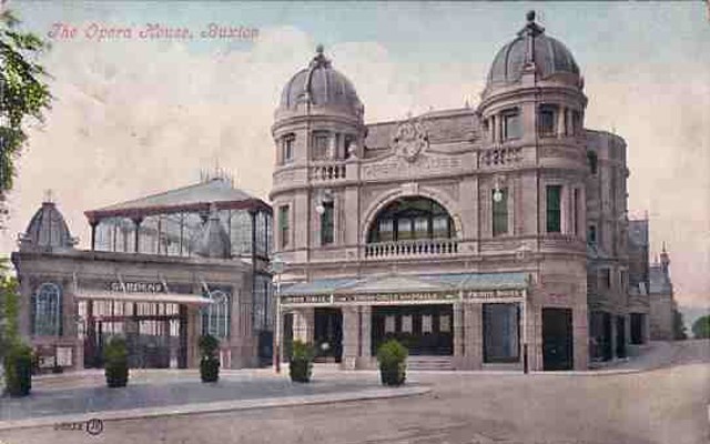
Waypoint 4: Buxton Opera House
Buxton Opera House was commissioned by the Buxton Gardens Company in 1901, following the success of the Pavilion Theatre (now the Pavilion Arts Centre). The highest opera house in the country, it was designed by Frank Matcham and was opened on 1 June 1903.
Matcham was a prolific theatrical architect who designed and built approx. 120 theatres and entertainment venues between 1879 and 1912, including the London Palladium, the London Coliseum and the Hackney Empire. Only about 20 of these survive as theatres.
In 1927 the theatre was turned into a cinema, and in 1932 it was wired for sound, for the 'talkies'. Despite its success as a cinema through the fifties and sixties, audiences began to diminish and the Opera House fell into disrepair, closing in October 1976.
The Opera House was restored in 1979, and an orchestra pit was added. An extensive programme of external and internal restoration was later undertaken between October 1999 and June of 2001, with further work carried out in 2007.
Waypoint 4 task: To the left of the main doors there is a brass plaque. How many letters are in the top line of wording on the plaque? This is LM.

Waypoint 5: The Pavilion Gardens
In the late 1860s, in an effort to increase the attractions for visitors to Buxton spa, the 7th Duke of Devonshire agreed to bear half the cost of a Winter Garden. Designed by Edward Milner and laid out on land given by the Duke, the Winter Gardens (later the Buxton Gardens and then the Pavilion Gardens) was opened in August 1871. This land was later extended to the present 23 acres by further gifts by the Duke.
The Concert Hall (now known as the Octagon), designed by the Buxton Architect Robert Rippon Duke, was added later and opened in 1875.
An Entertainment Stage was added in 1889. Run by the Buxton Gardens Company, it was known as the Pavilion Theatre, before becoming the Hippodrome cinema, the Playhouse (from 1935) and the Paxton Suite (from 1979).
Owing to the success of the theatre, the company decided that the Pavilion Theatre should be extended, which led to the commissioning of the Opera House in 1901.
The gardens were restored to their original layout in 2004, and the Pavilion Arts Centre was restored to its former glory and re-opened in 2010. The Octagon is currently undergoing extensive maintenance, and is due to reopen in 2017/18.
Waypoint 5 task: The waypoint co-ordinates take you to the bandstand. On the right of the bandstand there are two plaques. From this, what was the year he was born? This is NPQR.
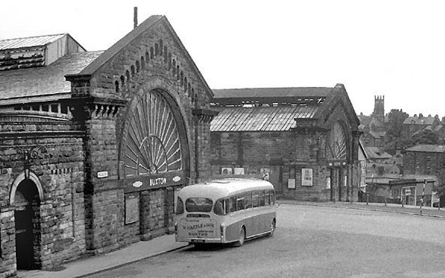
Waypoint 6: The Railway Station
The current railway station is all that is left of twin stations which were opened in 1863.
By the mid 1860s Buxton had become a popular spa town, and the arrival of the railways stimulated the town's growth: the population of 1,800 in 1861 had grown to over 6,000 by 1881.
Designed by Joseph Paxton, the twin stations were built out of local stone and had identical large semi-circle 'fan' windows, with each company's name engraved in a stone semi-circle around the window.
Initially operated by separate rival companies - the London and North Western Railway (LNWR) and Midland railway - by 1908 the two companies were co-operating, and in 1923 both stations became part of the London Midland and Scottish (LMS) Railway. Following the Second World War, in 1948 both stations became part of British Railways, and in 1963 the Beeching Report recommended that the former Midland Railway station be closed.
Although the Midland Railway station was later almost completely demolished, the LNWR station's fan window was restored in 2009.
More detailed information about the Midland Railway station can be found on my cache 'REALLY SideTracked - Buxton (Midland Railway)' (Premium-only).
Waypoint 6 task: There are two plaques on the wall here. The number on the right-hand plaque is TUVW.
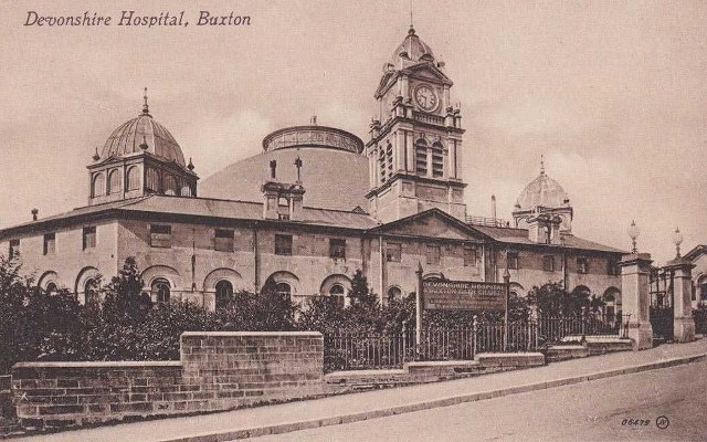
Waypoint 7: The Devonshire Dome
As part of the facilities developed by the Duke of Devonshire for the Crescent, the Great Stables was built between 1785 and 1789. Designed by John Carr, it housed the horses and servants of the guests of the Crescent hotels.
In 1859 the stables were largely converted to a charity hospital for the 'sick poor' by Henry Currey, architect to the 7th Duke of Devonshire and previously of St Thomas' Hospital in London. It became known as the Devonshire Royal Hospital in 1934.
Later conversion included the addition of the Devonshire Dome, which was designed by local architect Robert Rippon Duke and constructed in 1882. At the time it was the world's largest unsupported dome with a diameter of 144 feet (44m), larger than the Pantheon at 141 feet (43m), St Peter's Basilica at 138 feet (42m) in Rome, and St Paul's Cathedral at 112 feet (34m). It is still the largest unsupported dome in the United Kingdom.
The building and its surrounding Victorian villas are now part of the University of Derby.
Waypoint 7 task: To the left of the main gate is a metal fence, about 5-6m long. How many vertical spindles are on the fence? This is YZ
The Cache
Once you have all the numbers, use the following formula to work out the co-ordinates for the cache location:
N53 NZ.(F+Q)KM
W001 (E+Y)(M-J).V(N+H)Y
The cache is located not too far away. Please take your own pen/pencil, as there isn't one in the cache, and you do need to sign the logbook to claim a find. There are shops in the town centre which sell pens/pencils if you have forgotten to bring your own.