INTRODUCTION
The purpose of this EarthCache is to describe a few of the earth science concepts that explain some of what you’ll see on this outstanding hike. The exposed rock on this ridge is unique in all the world, and evidence of the last ice age is everywhere.
PART I: HOW ROCKS ARE MADE
The diagram below shows the rock cycle, which describes how types of rocks are transformed from one to another. Starting at the top, sediments or small grains of pre-existing rocks and minerals are moved and deposited by erosion, where they are compacted under their own weight and cemented together (lithified) when materials dissolved in the water come out of solution and crystallize as the water is squeezed out. Rocks formed when minerals crystallize directly from solution are also called sedimentary.
Over time movement in the earth's crust can apply great pressure between large pieces (or plates) crashing together, or push rock deep under the surface where it is subjected to intense heat, when the edge of one plate rides over another. The rock doesn't melt in these cases, but its crystal structure is transformed, and it can be bent and folded or broken during these processes.
Certain areas in the earth's crust are hot enough to melt rock. Molten rock under the surface is called magma. Solid rock formed when magma crystallizes without coming to the surface is called intrusive igneous rock. When magma comes to the surface through volcanoes it is called lava, which forms extrusive igneous rocks when it cools and solidifies.
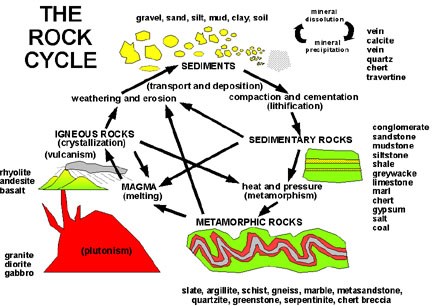
(USGS graphic, public domain)
The rock cycle diagram shows the processes that turn all types of rock into other types. Specific kinds of rock found in the Northeast United States are listed near each type.
PART II: MOUNTAIN BUILDING
In addition to changing the nature of the rocks involved, when the plates of the earth's crust collide with one another, they form mountains in several different ways. (See the source material here for a more complete description.) Geologists call such a period of mountain building an orogeny. Four distinct orogenies that formed the mountains in the Northeast United States are listed in the time scale diagram below.
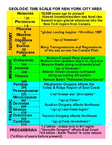
(USGS graphic, public domain)
In between periods of mountain building the forces of erosion broke down the rock and carried the sediments to lower areas where it was deposited just as we see all around us today.
PART III: THE GREEN POND OUTLIER
A belt of sedimentary rock deposited during the Silurian and Devonian periods survived the forces of nature in a kind of trench in the much older (precambrian) rock all around it. The youngest layer of that rock is called skunnemunk conglomerate, and forms the top of Skunnemunk Mountain, Bellvale Mountain, and Bearfort Mountain (where you are hiking for this cache).
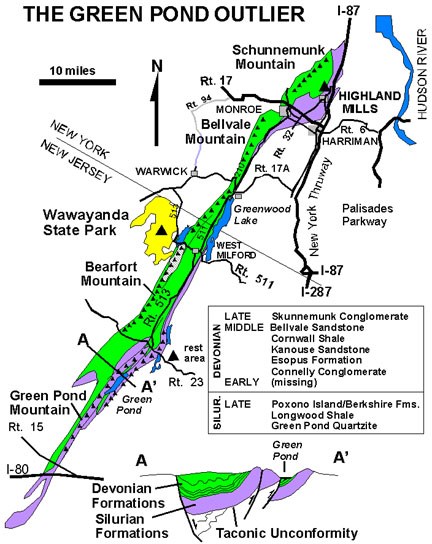
(USGS graphic, public domain)
The skunnemunk conglomerate is one of the best examples of "puddingstone" in the world. Its reddish to purple color comes from the iron rich sediment that cements together pebble to cobble sized materials washed from mountains formed in the Taconic orogeny, then folded into a great ridge during the Alleghenian orogeny, and finally exposed by glaciers ripping away the material around and over this layer.
PART IV: ICE SHAPES THE ROCK
The final chapter in this lesson is about the great ice sheets that covered this part of the earth thousands of feet thick. Glacier ice flows like a very slow moving river, picking up rock material as it goes, and scouring the earth underneath like an enormous sandpaper. You'll see several clear signs of this process on your hike.
Rock and sand carried in the ice smoothed the rock underneath and left scratches (striation) and larger grooving in the direction of the ice flow. The waypoints highlight a couple of the best examples of grooving in this area directly on the blue trail.
At the edge of the ice sheet where the ice melts, all the rock and sediment it carries is dropped. When the glacier melts faster than the ice is flowing, the edge retreats (moves upstream) and the material dropped by the melting ice can include huge boulders called erratics. An erratic is often very different rock material than the bedrock where it was deposited as it could have been carried many miles by the glacier.
A retreating glacier may leave large areas covered by chunks of ice while sediments are deposited all around it. When the ice melts it leaves a depression since it displaced the material that settled around it. These depressions often fill and form kettle lakes or glacial lakes. Terrace Pond on this hike is a beautiful example of a glacial lake.
LOGGING REQUIREMENTS
The primary requirement is to enjoy this hike. Photos are optional but add enjoyment for the cache owner and future visitors.
1: At GZ you'll find a huge erratic, hence the name of the cache. What type of rock is it, and what is the name given to this particular layer?
2: Describe the color, size and shape of the smaller rocks that the Red Monster is made of.
3: Near the Red Monster, the bedrock on which it rests is exposed in several areas. (Directly in the trail along the NE side is an excellent example.) How does the color, size and shape of the components of this rock suggest that the Red Monster came from somewhere else?
ACKNOWLEDGEMENTS
This cache is based largely on material found in the USGS e-book: Geology of the New York City Region, U.S. Geological Survey, 2003 . The graphics used in the cache description were taken directly from that source, and are in the public domain.

Geocache Identification Permit Approval Number: WSP2017020301
Permit Expires on: 03 FEB 2020