2WD is ok when it’s dry. It is not recommended for caravans. Your choice to complete this cache depends on your level of driving skill and experience.
Turnoff Eyre Hwy at S31 54.225 E127 01.929
Turnoff to the caves at S31 59.051 E127 01.795
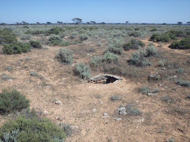
Park safely on the dirt track at a point BEFORE it dips down to the limestone. If you drive any further you will be on top of the caves. They are very fragile and hollowed out below ground and could collapse under the weight of your vehicle. There are many skylights / funnels above ground so take care when moving around them.
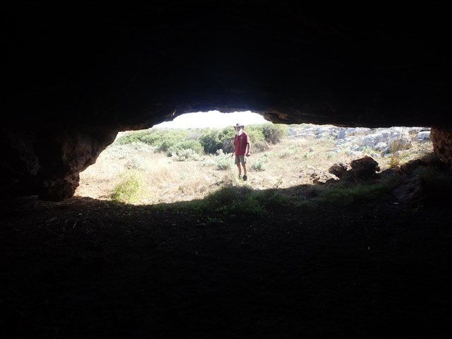
A good headlamp or torch is required.
The Nullarbor:
The vast limestone karst, which is the Nullabor Plain, is a fragile and beautiful thing. Its name comes from the Latin "Nulls Arbor" meaning ‘No trees’. This is simply a misconception as the vast region is most certainly not treeless and is far from boring. To the tribal aboriginal people the vast plain was known as the Oondiri, meaning a waterless plain, as surface water is not easily found across the ancient karst of limestone.
The Geology:
The Nullarbor Plain occupies most of the Eucla Basin. This limestone karst is the largest arid area of exposed limestone in the world. It formed 40 million years ago when the Australian continent broke away from Antarctica.
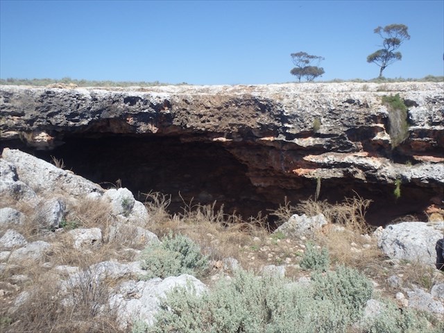
It sinks deep below the surface of the plain and can be easily seen at the magnificent Bunda Cliffs between Eucla and the Nullarbor Roadhouse. This limestone karst also erodes to form the pristine fine white sands of the beaches along the Baxter cliffs and Roe Plains but beneath the tablelands it is treacherous.
Many thousands of caves dot the Nullarbor karst. Some of the features include rocky ridges, broad pavements, caves, dolines, blowholes and circular clay-filled depressions called ‘dongas’.
For millions of years any surface water has easily seeped into the desert karst giving the plains the reputation of “the waterless lands”. Most of the caves on the Nullarbor were formed by the action of groundwater which dissolves the limestone in all directions to form telltale rounded walls. This often treacherous runoff has built vast rivers and caverns in the dark zones of the earth and this can be seen in many of the collapsed dolines (sinkholes) of the region.
Some passages collapse to become large underground chambers with high domed ceilings. Others penetrate the groundwater and lead from cool, clear lakes submerged well below the surface of the earth. Sinkholes are everywhere, as are the treacherous blow-holes when the Oondiri breathes, capturing its prey easily, sucking life into its dark world.
Madura Cave:
We found the safest and most accessible of the caves is Madura Cave, which sits down on the Roe Plain and is open to a careful scramble. Madura Cave is located in southeast Western Australia at a distance of about 1060km east from Perth. The entrance to Madura Cave is about 22m above sea level and is an example of a collapsed doline.
Remember to take only photos and leave no trace of your visit. We hope you enjoy your visit to this geologically interesting area 'on the long drive' in Western Australia.
In order to get your smiley you may log this Earthcache straight away but then please email your answers to the questions to the CO. We will contact you ONLY if your answers need extra work. Logs with no answers sent will be deleted. Please do not post your answers in your log.
There are two caves at this location. Walk in to one at S31 59.090 E127 02.406.
Q1. What material is the cave made of?
Q2. Note that there is a light-coloured, deeply-grooved band at about head height throughout the cave. Why do you think it has eroded at a greater rate than the rock surrounding it?
You need to crawl into the other cave at S31 59.077 E127 02.389. There is a longitudinal fault-line running throughout the width of the cave roof. It started as a crack and water seepage over time has eroded out the limestone. There are two skylights in this cave. Advance carefully to the second skylight / funnel about 50 metres in.
Q3. How has the skylight / funnel been formed?
Q4. What has caused the discolouration around the perimeter of the skylight walls?