South Pasture Swamp Background Information
(Provided by the RBG -Royal Botanical Gardens)
Spring fed creek oxbow - The 10 hectare South Pasture Swamp Special Protection Area is located in the central portion of Hendrie Valley and forms the core habitat of the valley. It is based on a large oxbow pond on the south side of Grindstone Creek, set against an old growth forest slope. This slope is part of the glacial Lake Iroquois beach and is made of sand. As a result, the oxbow pond is heavily fed by springs, receiving a constant supply of cool clean water. This wetland area is part of a string of ponds totaling over 25 hectares in area along lower Grindstone Creek. Grindstone creek itself flows from East Flamborough and Aldershot into the northwest corner of Hamilton Harbour and is the regions second largest creek. South Pasture Swamp contains areas of cattail (Typha sp.) organic shallow marsh, white water lily (Nymphaea tuberosa) floating-leaved shallow aquatic, and water willow (Decadon verticillatus) organic marsh. The sites name originates with the historical cattle pasture use of the valley. The clean water and restored plant community form the core habitat of the valley system providing a retreat for mink, muskrat, beaver, wood duck, and a variety of rare turtles and birds. The area is also the primary eastern Lake Ontario spawning area for northern pike. The adjacent band of forest contains towering black and red oak, and sugar maple, with the understory plants characteristic of more northern areas. Creekside Walk and South Bridle Trail provide access to the area. A newly created observation platform can be found at the western edge of the swamp where visitors are encouraged to relax and enjoy the heart of Hendrie Valley. Access is a 1 km walk from Cherry Hill Gate entrance next to Hendrie Park.
What Is An Oxbow?
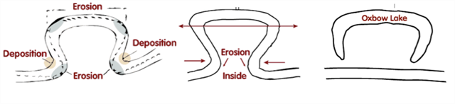
An oxbow is a crescent-shaped lake lying alongside a winding river. The oxbow lake is created over time as erosion and deposits of soil change the river's course. You can see how an oxbow lake takes shape below:
On the inside of the loop, the river travels more slowly leading to deposition of silt. Meanwhile water on the outside edges tends to flow faster, which erodes the banks making the meander even wider. Over time the loop of the meander widens until the neck vanishes altogether. Then the meander is removed from the river's current and the horseshoe shaped oxbow lake is formed. Without a current to move the water along, sediment builds up along the banks and fills in the lake.
What Is a Marsh?
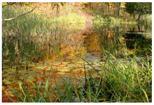
Marshes are defined as wetlands frequently or perpetually covered with water. They are characterized by emergent soft-stemmed vegetation adapted to saturated soil conditions. Emergent plants have their leaves above water level and their roots in the soil below. There are many different kinds of marshes, but all types receive most of their water from surface water, and many marshes are also fed by groundwater. Marshes contain shallow water varying from 15 to 90 cm in depth. Nutrients are plentiful and the pH is usually neutral leading to an abundance of plant and animal life. Very large areas of open water are uncommon and islands of vegetation are often present. Marshes are the most common wetland type in North America.
Marshes moderate stream flow by providing water to streams - an important function during periods of drought. The presence of marshes in a watershed helps to reduce damage caused by floods by slowing and storing flood water. As water passes slowly through a marsh area, sediment and pollutants settle to the floor of the marsh. Marsh vegetation and microorganisms also use excess nutrients (such as nitrogen and phosphorus from fertilizer) for growth that can otherwise pollute surface water. This wetland type is very important to preserving the quality of surface waters.
Because of their high levels of nutrients, freshwater marshes are one of the most productive ecosystems on earth. They sustain a vast array of plant communities that support a wide variety of wildlife within the wetland. As a result, a marshes sustains a diversity of life that is way out of proportion to its size.
These habitats can be found along the shores of the Great Lakes and in sheltered bays such as Cootes Paradise and also along rivers or in other depressions across the broader landscape. They have fluctuating water levels, particularly when they are isolated from large water bodies.
What is a Swamp?
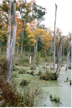
A swamp is a wetland type associated with streams, rivers or lakes which has water flowing through it. They are often confused with marshes but are distinguished by the presence of trees and shrubs. Swamps occur on saturated soils and are flooded for most or all of the growing season. The main swamp region in Ontario occurs in the Great Lakes region.
A swamp is any wetland dominated by woody plants. Swamps are characterized by saturated soils during the growing season, and standing water during certain times of the year.
The highly organic soils of swamps form a thick, black, nutrient-rich environment for the growth of water-tolerant trees such as cypress and some types of white cedar. Most of our Southern Ontario swamps are dominated by hardwood tree species such as Red Maple and Silver Maple. Some swamps are dominated by shrubs, such as button bush or smooth alder. Plants, birds, fish, and invertebrates such as freshwater shrimp and crayfish need the habitats provided by swamps.
Swamps are forested wetlands and the Hamilton area is one of the best places in Canada to see them. These wetlands can form along lake shores but are more often found along shallow rivers or in low-lying areas where the soil is not flooded all year long.
What Is a Pond?
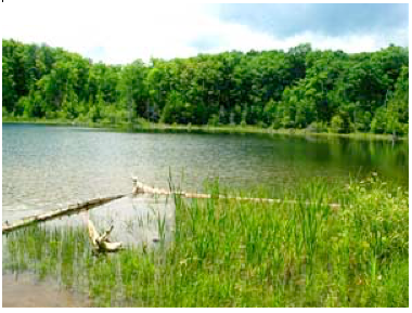
Small bodies of shallow open waters of standing or gently flowing water represent a transitional stage between lakes and marshes. They are called ponds and vary greatly in physical and chemical composition. Their mid-summer depth is less than 2 m and open expanses of water comprise at least 75% of their area. Their surface is generally free of vegetation. Unlike lakes, the water temperature in shallow open waters is uniform, lacking any stratification. (Information provided by Toronto Hiking - Southern Ontario Hiking Resources)
Requirements for Claiming this EarthCache
To claim a find, E-mail the answers for this EarthCache, to the CO at the top of the page.
1) After reading over the cache page, standing on the look-out platform, take a look at the wetland in front of you:
a) List some of the characteristics of a marsh that you see here.
b) List some of the characteristics of a swamp that you notice here.
c) List some of the characteristics of a pond that you see at this site
d) What kinds of wildlife (animals) did you see, during your visit to this location.
2) Use the information from your reading, and what you notice here, what do you think is the main source of the water flowing through the area, there are two.
3) Estimate the length of the Oxbow.
Optional: Photos, lots of photos! If you see something interesting at the South Pasture Swamp, please include a photo of it in your log.
Visiting first thing in the morning, or later in the evening will likely yield the best wildlife viewing opportunities.
I have also included a wonderful link that explains the difference between Ontario’s four different types of wetlands. https://www.youtube.com/watch?v=BqK6mfhJ2Tk