Geology of Tongatapu
The island of Tongatapu consists of uplifted and tilted crust and, along with Eua and Vava'u, tilts towards the weight of the Kao and Tofua volcanoes in the Ha'apai island group. Tonga sits above the subduction zone where the Pacific plate subducts under the Indo-Australian plate and as such is prone to regular volcanism and seismic activity.
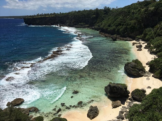
Tongatapu consists mostly of a limestone raised reef on an ancient volcanic base. It is largely flat, gently rising from the north side of the island, where there exist many inlets and lagoons, to the south and eastern sides of the island that end abruptly with cliffs into the sea.
The porous limestone that makes up Tongatapu drains water away from the surface, and seepage into the surrounding seawater means that the fresh water table is typically only 1m above sea level. Another property of limestone is the typical presence of solutional (karst) caves due to the limestone dissolving in weak acids usually produced by the decomposition of organic matter - and at this earthcache's location is an impressive example of such geology.
Hufangalupe - Pigeon's Doorway
The natural bridge at Hufangalupe, translated 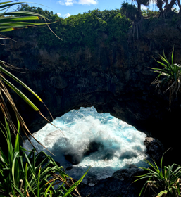 as Pigeon's Doorway, is the result of the inland collapse of a large cave connected with the sea. The cave was formed by a combination of dissolution of the limestone rock, in addition to the wind and wave action from the sea. Ultimately the cave roof became weakened and collapsed during an earthquake. The cave collapse left a natural and distinctly solid limestone bridge that crosses between the cave opening and the sea.
The bridge can be walked across and even driven across, as the Pacific Ocean crashes through the entrance beneath.
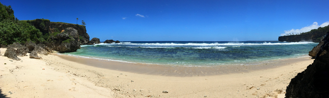
Hufangalupe Beach
Nearby to the natural bridge, you can access the Hufangalupe Beach, a stunning stretch of sand where you can enjoy some peace and if the tide is right go for a swim, while pondering your answers to this earthcache. There are also some large rocks here that were tossed onto the island by a huge tsunami.
Earthcache Tasks
In order to log this earthcache as found you need to visit the site and complete some educational tasks. The answers to the following questions should be emailed to the cache owner by using the link at the top of the cache page. Do not include any spoilers to the answers in your online log.
1. Please describe the shape and estimate the dimensions of the collapsed cave.
2. Estimate the dimensions of the natural bridge - horizontal length and width, and the thickness of the bridge in the middle.
3. Can you identify any features of the rock that confirm the karst nature of the rock that makes up the bridge or the collapsed cave?
4. (Optional): Take a photo of yourself, your GPS or just the view showing the stunning view over Hufangalupe Beach and add it to your log.
Please log your find at the same time as your email me your answers. However, if your answers are incomplete or wrong you will be asked to provide more details. If this is not provided the log will be deleted.