Antigua can be divided into three geological zones; volcanic mountains in the southwest, a central plain of marl (lime-rich mud) and clay overlying volcanic material, and limestone hills in the northeast. Devil’s Bridge, a natural arch, lies in the northeastern portion of the island known as the Antigua Formation. Composed of limestone rock, the terrain surrounding Devil’s Bridge is the result of millions of years of ancient coral reef formation.

Devils's Bridge
ARCH TYPES AND FORMATION
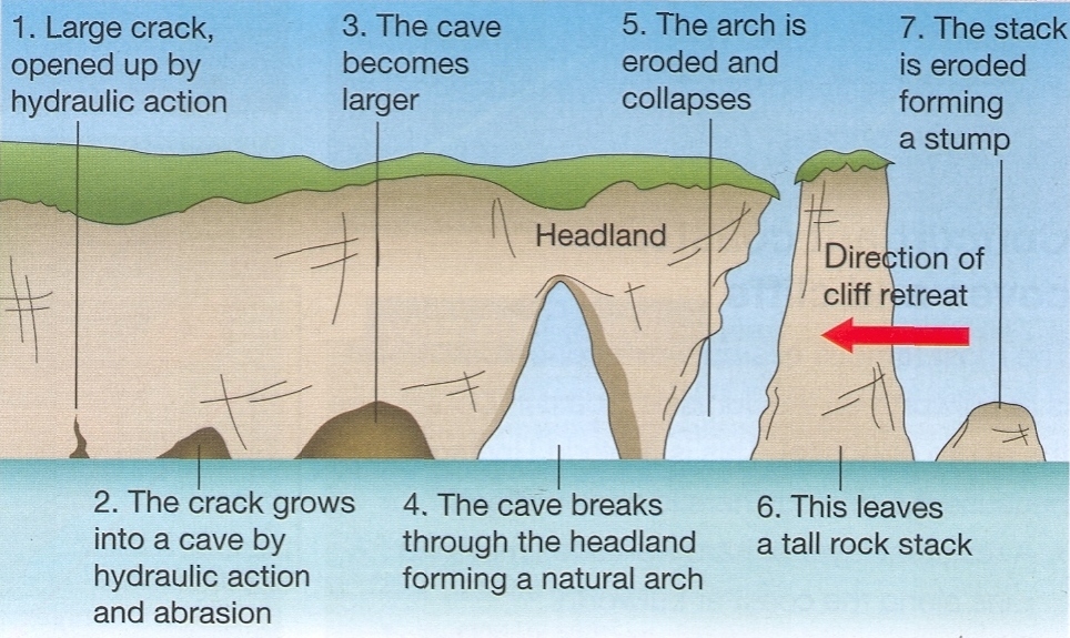
On coasts two different types of arches can form depending on the geology of the region. On discordant coastlines rock types run at 90° to the coast. Wave refraction concentrates the wave energy on the headland, and an arch forms when caves break through the headland. When these arches eventually collapse, they form stacks and stumps.
On concordant coastlines rock types run parallel to the coastline, with weak rock such as shale protected by stronger rock such as limestone. The wave action along concordant coastlines breaks through the strong rock and then erodes the weak rock very quickly. Numerous geysers and blowholes can surround the arch as waves continually break against the coastal rocks.
EROSION
In earth science, erosion is the action of surface processes (such as water flow or wind) that remove soil, rock, or dissolved material from one location on the Earth's crust, then transport it away to another location. The particulate breakdown of rock or soil into clastic sediment is referred to as physical or mechanical erosion; this contrasts with chemical erosion, where soil or rock material is removed from an area by its dissolving into a solvent (typically water), followed by the flow away of that solution. Eroded sediment or solutes may be transported just a few millimetres, or for thousands of kilometres.
There are numerous forms of erosion including but not limited to:
Water Erosion
Water erosion occurs from the chemicals in the water, and the force of the flow of water in the river. There are many chemicals in the water of a river, and those chemicals can break down certain rocks, such as limestone or chalk. Sometimes, a crack or crevice develops. When the force of the flowing water smashes into that crack, the rock can break away, and again be carried away; this is also known as hydraulic action.
Wind Erosion
Wind erosion, though it may be small where you live, can take quite a toll on areas of the world covered in desert. Wind erosion is simple... light objects, such as rocks and pebbles are carried by the wind and can hit landforms, eroding materials off them, that are carried off in the wind.
Glacier Erosion
Ice erosion, besides that of hail, comes mostly in the form of glacier erosion. Glaciers are giant bodies of ice that can pick up huge pieces of rock, some even as big as houses. A combination of the water, ice, and picked up sediment, create a powerful eroding machine.
Sea Erosion
Erosion in seas can also occur. The salts and other chemicals can erode weak rocks on coasts, such as limestone and chalk. The eroded materials are carried up the shore by the means of a longshore drift. Waves crashing against the shore can create air pressure inside cracked rocks, that can eventually break them. Furthermore, if rocks, pebbles or sediment is carried in the waves, they can smash up against the shore and erode it even more.
Soil Erosion
Soil erosion occurs when flooding, wind, etc. carries topsoil away from the land.
Logging Requirements:
To log this Earthcache, determine the answers to the questions below and provide a brief rationale for each one. Email me your answers, DO NOT include them with your Found It log.
- Is the coastline at Devil’s Bridge an example of a discordant or concordant coastline?
- What types of erosion are responsible for the creation of Devil’s Bridge?
- If Devil's Bridge were to suddenly collapse, would a stack result?