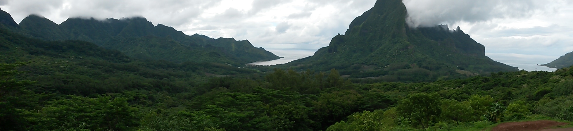
Le mont Rotui, les baies de Cook et d'Opunohu vus du Belvédère (au premier plan, la caldeira)
View from the belvèdère: Mount Rotui, Cook and Opunohu bays ( in the foreground: the caldera)
Moorea fait partie des îles du Vent dans l'archipel de la Société, un des 5 archipels de la Polynésie française.
Génèse et évolution de l'archipel de la Société
Les îles de la Société résultent de l'activité volcanique d'un point chaud fixe, situé sous la lithosphère océanique, actuellement proche de l'île de Mehetia (25 000 ans d'âge) à 190 km à l'est de Moorea.

En raison de la dérive des continents, la plaque Pacifique se déplace vers le nord-ouest d'environ onze mètres par siècle, la production magmatique du point chaud génère au fil du temps un alignement, orienté sud-est/nord-ouest, d'îles et de volcans sous-marins.
Lorsqu'un volcan sous-marin de l'archipel atteint la surface, une nouvelle île volcanique voit le jour.

Ce volcan est de type hawaïen. Il est très aplati et à faible pente (15%) : c'est un volcan-bouclier. Sa lave est basique, très fluide avec peu de gaz. Elle s'écoule sans explosion et se refroidit lentement. Très rapidement l'érosion commence à dégrader les pentes du jeune volcan et des coraux colonisent les rives de l'île.
En s'éloignant de la dorsale océanique (zone où se forme la lithosphère océanique), la plaque océanique se refroidit, s'épaissit et s'enfonce progressivement (phénomène de subsidence). Dans sa lente translation horizontale et verticale, elle entraîne avec elle le cône volcanique qui diminue en hauteur et en circonférence sous les actions combinées de l'érosion et de la subsidence.
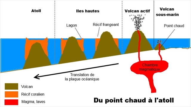
A l'opposé, la ceinture de corail continue de croître régulièrement. Les coraux affleurent la surface de l'océan. Ils semblent s'éloigner du rivage de l'île.
Quelques millions d'années (MA) plus tard, il ne reste plus qu'un volcan très délabré au milieu d'un vaste lagon (Bora-Bora : 3,2 MA).
Enfin, l'édifice volcanique résiduel va disparaître ne laissant en place qu'un anneau de corail : un atoll. C'est la phase ultime des effets de l'érosion et de la subsidence sur les îles.
Les atolls sont les îles les plus vieilles de l'archipel de la Société (Maupiti : 4,3 MA) et les plus éloignées du point chaud (700 km).
Le volcan-bouclier de Moorea
Géographie
L'île est de forme triangulaire et mesure 16 x 12 km. La base du triangle est au nord et le sommet au sud. Moorea est déjà très abîmée par l'érosion. On ne retrouve pas les pentes du volcan-bouclier originel. Elles devaient avoir une inclinaison de 15 à 20°.
Aujourd'hui, la ligne de crête principale, très déchiquetée, forme un V ouvert sur la mer au nord. Le point culminant de l'île, le mont Tohiea (1207 m), est à la base du V. Plein nord et isolé au centre du V, tel une gigantesque canine, se dresse le mont Rotui (899 m). De chaque côté du mont Rotui, 2 profondes baies (Cook à l'est et Opunohu à l'ouest) entaillent la base du triangle.
Histoire géologique de l'île
On trouve les roches les plus anciennes du volcan-bouclier de Tohiea près d'Afareaitu. Ce sont des brèches lahariques (débris de roches volcaniques de toutes tailles dispersées dans des coulées de boues).
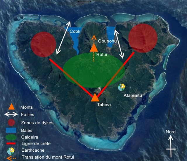
Les premières coulées effusives apparaissent au Belvédère en plein centre de l'île. La construction du bouclier est très rapide à l'échelle géologique (200 000 ans quand même...). La caldeira principale se situe entre le mont Tohiea et le mont Rotui. Avec l'élévation du cône apparaissent à la fin de l'éruption principale, des coulées secondaires à travers des dykes ( lames de roches volcaniques qui se sont infiltrées dans une fracturation de l'encaissant) du bouclier au nord-ouest et au nord-est de la caldeira. Les laves émises sont de composition chimique complexe. Ces dykes vont fragiliser la caldeira principale et déclencher sa fracturation puis son effondrement.
Deux failles, au nord-ouest et au nord-est de la caldeira, vont favoriser, lors de l'effondrement du mur de cette dernière, un glissement vers le nord du massif du Rotui et probablement la création des baies d'Opunohu et de Cook.
Pour terminer, l'érosion va sculpter l'île au fil des millénaires et lui donner l'image que nous connaissons aujourd'hui.
Magmas et roches volcaniques
Les magmas sont classés suivant leur teneur en silice. Ils sont acides et visqueux s'ils contiennent plus de 63 % de silice. Ils sont basiques et liquides si leur teneur en silice est inférieure à 53 %. Entre 53 et 61 %, ils sont dits intermédiaires.
Quelques exemples de roches volcaniques :
L’obsidienne est une roche volcanique vitreuse, lisse et non granulaire. De couleur noire, elle est issue d'une lave acide (riche en silice).
Le basalte est une roche magmatique effusive à grain fin. De couleur noire, il s'altère en vert sombre ou marron. Il est issu du refroidissement du magma au contact de l'eau ou de l'air. Sa surface peut présenter des vacuoles (bulles de gaz) et peut être lisse et douce ou rugueuse et anguleuse. Cette lave basique est le constituant principal de la couche supérieure de la croûte océanique.
Un trachyte est issu d'une lave intermédiaire plutôt alcaline. Généralement de couleur grise, il contient des phénocristaux de feldspath, pyroxène, amphibole. Ce qui lui donne une surface marbrée, rubanée, plus ou moins rugueuse.
Les basaltes de Moorea
A l'exception du récif corallien, tous les matériaux de Moorea sont des basaltes alcalins (basaltes à zéolites, basaltes vacuolaires, basaltes prismés, hawaiites, trachyphonolites ou des basaltes intermédiaires (trachytes, benmoréites, mugéarites).
La présence de ces laves plus ou moins évoluées s'explique par l'existence d'une chambre magmatique complexe, à plusieurs étages et plusieurs cheminées qui a permis le mélange des différents matériaux en fusion.
Moorea is part of the Windward Islands in the Society Archipelago, one of the 5 archipelagos of French Polynesia.
Genesis and evolution of the Society Archipelago
The Society's islands are the result of the volcanic activity of a fixed hot spot located under the oceanic lithosphere, currently close to Mehetia Island (25,000 years of age) 190 km east of Moorea.
Due to continental drift, the Pacific plate moves northwest about eleven meters per century, magmatic hot spot production over time generates a south-east / north-west alignment of Islands and submarine volcanoes.
When a submarine volcano of the archipelago reaches the surface, a new volcanic island emerges.
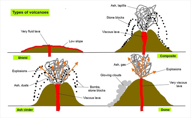
This volcano is Hawaiian type. It is very flat with low slopes (15%): it is a volcano-shield. Its lava is basic, very fluid with little gas. It flows without explosion and cools slowly. Very quickly erosion begins to degrade the slopes of the young volcano and corals colonize the shores of the island.
From the zone where the oceanic lithosphere is formed (mid-oceanic ridge), the oceanic plate cools, thickens and sinks progressively (subsidence phenomenon). In its slow horizontal and vertical translation it draws with it the volcanic cone which diminishes in height and circumference under the combined actions of erosion and subsidence.
In contrast, the coral belt continues to grow steadily. Corals outcrop the surface of the ocean. They seem to be moving away from the shore of the island.
A few millions years (MA) later, there remains only a very dilapidated volcano in the middle of a vast lagoon (Bora-Bora: 3.2 MA).
Finally, the residual volcanic edifice will disappear leaving only a ring of coral: an atoll. This is the ultimate phase of the effects of erosion and subsidence on islands.
The atolls are the oldest islands of the Society archipelago (Maupiti: 4.3 MA) and furthest from the hot spot (700 km).
The volcano-shield of Moorea
Geography
The island is triangular and measures 16 x 12 km. The base of the triangle is to the north and the summit to the south. Moorea is already very damaged by erosion. We don't find the slopes of the original volcano-shield. They should have an inclination of 15 ° to 20 °.
Today, the main ridge line, very shredded, forms a V open on the sea to the north. The highest point of the island, Mount Tohiea (1207 m), lies at the base of the V. Plein north and isolated in the center of the V, like a gigantic canine, stands Mount Rotui (899 m). On either side of Mount Rotui, 2 deep bays (Cook to the east and Opunohu to the west) cut vertically the base of the triangle.
Geological history of Moorea
The oldest rocks of the shield of Tohiea were founded near Afareaitu. These are laharic breccias (debris of volcanic rocks of all sizes dispersed in mudslides). The first effusive flows appear at the Belvedere, in the center of the island. The construction of the shield is very fast on a geological scale (200,000 years anyway ...).
The main caldera lies between Mount Tohiea and Mount Rotui. With the elevation of the cone appear at the end of the main eruption, secondary flows through dykes (a dyke is a volcanic rock that infiltrate into a fracturing of the enclosing) to the northwest and the north-east of the caldera. The emitted lavas are of complex chemical composition. These dykes will weaken the main caldera and trigger its fracturing and collapse.
Two faults, north-west and north-east of the caldera, will favor, during the collapse of the wall of the latter, a gliding towards the north of the massif of the Rotui and probably the creation of the bays of Opunohu and Cook.
To finish, erosion will sculpt the island over millennia and give it the image we know.
Moorea basalts and volcanic rocks
Magmas are classified according to their silica content. They are acid and viscous if they contain more than 63% of silica. They are basic and liquid if their silica content is less than 53%. Between 53 and 61%, they are called intermediaries.
Some examples of volcanic rocks:
Obsidian is a vitreous, smooth and non-granular volcanic rock. This black rock comes from an acid lava (rich in silica).
Basalt is a fine-grained effusive magmatic rock. First colored in black, it alters in dark green or brown. It comes from the cooling of magma in contact with water or air. Its surface can have vacuoles (gas bubbles) and can be smooth and soft or rough and angular. This basic lava is the main constituent of the upper layer of the oceanic crust.
A trachyte is derived from a rather alkaline intermediate lava. Generally gray in color, it contains phenocrysts of feldspar, pyroxene, amphibole. This gives it a marbled surface, ribbed, more or less rough.
With the exception of the coral reef, all Moorea materials are alkaline basalts (zeolite basalts, vacuolar basalts, prismed basalts, hawaiites, trachyphonolites or intermediate basalts (trachytes, benmoreites, mugearites).
The presence of these more or less evolved lava is explained by the existence of a complex magma chamber, with several floors and several chimneys which allowed the mixing of the different molten materials.
Rappel concernant les « Earthcaches »: Il n'y a pas de conteneur à rechercher ni de logbook à renseigner. Il suffit de se rendre sur les lieux, de répondre aux questions ci-dessous et de nous renvoyer les réponses.
Pour valider cette earthcache :
Attention, vous avez besoin d'un mètre-ruban !
Pour valider votre visite sur le site, envoyez-nous, en anglais ou en français, en précisant bien en titre de votre message « GC6ZM9Y Moorea, un volcan-bouclier entre 2 âges », vos réponses par courrier électronique via notre profil ou la messagerie de geocaching.com aux questions suivantes.
Q1 : A partir du descriptif de la cache, calculez l'âge de l'île de Moorea. Détaillez/expliquez votre calcul.
Q2 : Quelles sont les caractéristiques d'un volcan de type hawaïen ?
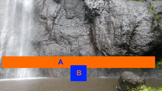
Q3 : Observez la paroi à droite de la cascade et décrivez-la. A quel type de roche pensez-vous (obsidienne, basalte, trachyte) ?
Q4 : Qu'y a-t-il de particulier à la base de cette paroi (zone A) ?
Q5 : Estimez le diamètre du trou à la base de la paroi (zone B).
Vous pouvez loguer "Found it", et nous vous contacterons en cas de nécessité.
Reminder concerning the "Earthcaches" : There is no container to be searched nor a logbook to be filled in. Just go to the premises, answer the questions below and send us the answers.
To validate this earthcache:
Warning, you need a yardstick !
To validate your visit on the site, send us, in English or in French, specifying well in title of your message "GC6ZM9Y Moorea, a volcano-shield between 2 ages", your answers by e-mail (to our profile , or on geocaching.com) to the following questions.
Q1: From the description of the cache, calculate the age of Moorea. Explain/detail your calculations
Q2: What are the characteristics of a Hawaiian-type volcano?
Q3: Observe the wall to the right side of the waterfall and describe it. To witch type of rock do you think (obsidian, basalt, trachyte)?
Q4: What is there at the base of this wall (A area)?
Q5: Estimate the diameter of the hole at the base of the wall (B area).
You can log "Found it", and we will contact you if necessary.