A fall line (or fall zone) is a geomorphologic unconformity between an upland region of continental bedrock and an alluvial coastal plain. A fall line is typically prominent when crossed by a river, for there will often be rapids or waterfalls. Many times a fall line will recede upstream as the river cuts out the uphill dense material, often forming c-shaped waterfalls.
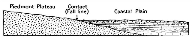
In the United States, the fall line occurs between the Piedmont (the foothills of the Appalachian Mountains) and the Coastal Plain. The line stretches from New Jersey south, paralleling to the coast to Georgia. It roughly follows the I-95 corridor (or, more accurately, I-95 was built to connect cities along the fall line). From Augusta, Georgia, the fall line curves west and extends to southeast Alabama. In some areas it appears as a cliff or escarpment; in other areas it is not as pronounced. Based on current scientific theory, the fall line is the ancient shoreline of the Atlantic Ocean (Mesozoic era -- the Age of Dinosaurs). It separates Upper Coastal Plain sedimentary rocks to the south from Piedmont crystalline rocks to the north.
The differences in geology above and below the fall line give rise to differences in soil types, hydrology, and stream morphology. Sandy soils predominate below the fall line, whereas clay soils are the rule above. Wide floodplains have developed along many of the streams below the fall line. Narrower stream valleys are present above the fall line. The fall line therefore separates very different plant and animal communities.
Here in Virginia, Captain John Smith was the first European to report on the fall line. In April, 1607, Smith, along with Captain Christopher Newport, explored the James River upstream from Jamestown. Their progress was blocked by rocks and rapids at Richmond. Of the fall line, Smith wrote, "[W]e were intercepted with great craggy stones ye in midst of the river, where the water falleth so rudely and with such a violence, as not any boat can possibly passe . . ."
The fall line is notable not only for the geological transition, but also for the impact that the geology had on early transportation and consequently on commerce and society. The falls that give rise to the term fall line are the shoals or waterfalls caused by the first exposure of crystalline rocks encountered when traveling upstream in rivers of the Coastal Plain.

The Fall Line in Virginia tracks the ancient shore line (and, roughly, I-95) north to south, from Alexandria to Fredericksburg to Richmond to Petersburg to Emporia. It's no coincidence that these towns are on the fall line. As Captains Smith and Newport found out, the fall line generally represents the upper limit of navigation from the sea. The rapid change in elevation of the water, and the resulting energy release, makes the fall line a good location for water mills, grist mills, and sawmills. At the time these cities were developing, boat traffic was much more efficient than land transport, so settlers wanted to push ports as far inland as possible. Because of the need for a river port leading to the ocean, and a ready supply of water power, settlements often developed where rivers crossed a fall line.
Richmond made good use of harnessing the energy of falling water here at the Fall Line. For example, on the north bank of the James, the Tredegar Iron Works and Crenshaw Woolen Mills both used water power to drive machinery in the 1800s. Over on Belle Isle, you can still see the remains of the Belle isle power plant, which harnessed hydroelectric power between 1904 and 1963. And the bridge on which you stand is built on the remains of the VEPCO Levee Dam, which was used from 1901 to 1968.
LOGGING THIS EARTHCACHE: This earthcache was designed so it could be answered without referring to the sign at the coordinates - but if you get stuck, it may help you put your answers together.
To log this cache, email us or send us a message https://www.geocaching.com/account/messagecenter?recipientId=affe57a7-1ae1-4e1e-9c43-39f2af466a78&gcCode=GC6ZN4J and copy and paste these questions, along with your answers. Please do not post the answers in your log, even if encrypted. There's no need to wait for confirmation from us before you log, but we will email you back if you include your email address in the message. Group answers are fine; just let us know who was with you.
1. The name of this earthcache: Richmond Fall Line Earthcache
2. Into which body of water does this river flow? (There is more than one right answer for this.)
3. Look all around you. Name at least one historical means of harnessing the energy of the falling water.
4. Do you see any ways the Fall Line is still being used today?
Pictures of your visit are not required to log this cache, but are highly encouraged.
SOURCES
Virginia Places: Geology of the Fall Line
U.S. Geological Survey, Virginia geologic map data
Ed Southern, ed., The Jamestown Adventure: Accounts of the Virginia Colony, 1605-1614.
Wikipedia