Scroll down for English...
[TR]
Not: Gölyazı yaz aylarında çok kalabalık olduğu için köy araç girişine kapatılmaktadır. Yaz aylarında aracınızı köyün girişindeki park alanına bırakıp yürümek zorundasınız. Kış aylarında ise köyün içine kadar aracınızla girebilirsiniz. Heryer çok kalabalık olacağı için lütfen gizliliğe önem verin.
Zambak Tepe
Zambak Tepesi hem adaların hemde gölün yukarıdan izlenebileceği, mükemmel bir gün batımının seyredilebileceği eşsiz bir manzaraya sahiptir. Küçük bir yürüyüş ile veya aracınızla (kış aylarında) buraya ulaşabilirsiniz.
Ayrıca söz konusu tepede Roma Tiyatrosu kalıntıları ve 150 yıldan yaşlı anıt ağaçlar bulunmaktadır. Burası tarihi eser sevenlerin ve fotoğrafçıların uğrak mekanıdır. Yakın zamanda bu bölgede arkeolojik kazılara başlanması planlanmaktadır.
Mübadele öncesi yörede yaşayan Rum halkı vefat edenleri mükemmel manzarası olan bu yere gömerlermiş. Mezarların etrafına ise hep zambak dikerlermiş. Yani burası eskiden zambaklarla dolu bir mezarlıkmış. Bu yüzden burası Zambak Tepe adını almış. Günümüzde ise o mezarlardan bir eser yok.
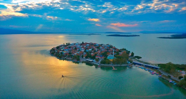
 Zambak Tepe'den Gölyazı manzarası
Gölyazı
Apollonia ad Rhyndakos
Bursa-Karacabey yolunun 35. Kilometresinde, yolun 6 km güneyinde bulunan Gölyazı, Uluabat Gölü’nün doğu ucunda karaya ince bir bağlantısı olan yarımadanın üzerine kuruludur. Kışın suların yükselmesiyle ada halini alır. Namıdiğer ‘Apolyont’un bilinen tarihi MÖ 5. yüzyıla dayanıyor. Tarihte ‘Apollonia’ olarak da anılan bu yerleşim; ismini kentin koruyucu tanrısı olan, mitolojide sanat, müzik, güneş ve ateş tansırı olarak geçen Apollon’dan almıştır. Kayıtlarda diğer Apollonia şehirleri ile karışmaması için Apollonia ad Rhyndakos, yani Rhyndakos (Kocasu/Mustafakemalpaşa veya Orhaneli) Çayı kenarındaki Apollonia olarak geçer. Apollonia, Efes liman kayıtlarına göre, İmparatorluk döneminde bir liman kentiydi.
Antik kent; ada ve anakara üzerindeki Zambak Tepe bölgesinden oluşur. Halk arasında ‘Taş Kapı’ denilen ‘Dış Kale’ kentin girişini denetim altına almak amacıyla yapılmış. ‘Simitçi Kale’ olarak da bilinen yapının duvar kalıntıları bugün kalenin eski görkemli günlerini yaşatmak istercesine ayakta durmaya çalışıyor. Yöre halkınca ‘Gavur Mezarlığı’ adıyla anılan sırtta bulunan antik tiyatro, okul bahçesinde yer alan yel değirmeni, Sübyan Mektebi ve anakarayı Gölyazı Adası’na bağlayan köprünün başındaki ‘Ağlayan Çınar’ ismi ile bilinen tarihi çınar, bu eşsiz yerleşimin tarihi değerlerinden.
 Gölyazı
Gölde, Apollonia kentinin ve köyün üzerinde kurulu olduğu alanın dışında, irili ufaklı birçok adada tarihi kalıntılar bulunuyor. Manastır Adası’nda 9. ve 10. yüzyıllarda yapıldığı düşünülen Hagios (Aziz) Konstantinoz Kilisesi ve Kız Adası'ndaki Hellenistik Dönem’e (MÖ 4. yy.-MÖ 1. yy.) ait Apollon Kutsal Alan kalıntıları bölgenin diğer önemli tarihi değerleri arasında. 19. Yüzyılın ikinci yarısında inşa edilen Hagios (Aziz) Panteleimon Kilisesi, Yunan klasik mimarisinin önemli örneklerinden. Yıllarca harabe halinde kalan kilise, 2009 yılında Nilüfer Belediyesi tarafından restore edildi. Günümüzde Kültürevi olarak kullanılıyor. Restorasyonu 2014 yılında tamamlanan ‘Göl Yazıevi’ ise yazar ve çevirmenleri kilisenin hemen yanında yer alan tarihi ev ortamında ağırlıyor.
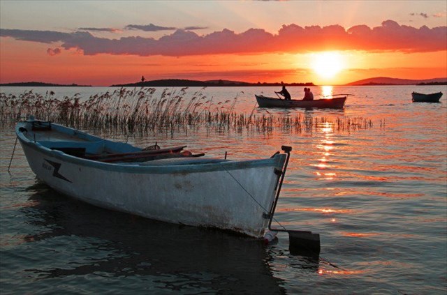 Uluabat Gölünde gün batımı
Osmanlı Dönemi’nde kent oldukça küçülerek sadece ada üzerinde kalmıştır. 1300’lerin başında gerçekleşen Osmanlı Fethinden Kurtuluş Savaşı ve 1923 yılındaki Mübadele Antlaşması’na kadar burada yaşayan Rumlar, nüfus değişimi kararı ile Yunanistan’a; Yunanistan’da yaşayan Müslüman Türkler de değişime tabi olan bu topraklara yerleşmiştir.
Günümüzde doğal ve tarihi güzellikleri ile hayranlık uyandıran yerleşime ev sahipliği yapan Uluabat Gölü, dünya üzerindeki önemli sulak alanlardan ve sayılı yaşayan göllerden biri olması nedeni ile 2001 yılında Ramsar statüsü kazanarak yaşayan göller ağına dahil oldu. Geniş ve sığ olan göldeki küçük adacıklar ve geniş sazlıklar su kuşları için yaz ve geçiş mevsimlerinde önemli bir sığınak merkezidir.
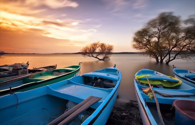 Uluabat Gölü
Uluabat Gölü Ramsar Alanı
13500 hektarlık bu alan sulak alanların dünya çapında korunmasını ve sürdürülebilir kullanımını geliştirmek amacıyla 1971 yılında Ramsar’da (İran) imzalanan Sulak Alanlar Sözleşmesi’nin uluslararası öneme sahip sulak alanlar listesine dahil edilmiştir.
ÇOK ÖNEMLİ!
Bu kısma özellikle dikkat etmenizi rica ediyorum. Lütfen spoiler olabilecek bir fotoğraf eklemeyin veya log yazarken ekstra bilgi vermeyin. Eğer kutu ile ilgili bir yorumunuz varsa bana mesaj atabilirsiniz. Kutuyu bulan oyuncuların kutu kayıp olsa dahi kutu sahibinden onay almadan kutuyu yenilememeleri beklenmektedir.
BYOP: Kendi kaleminizi yanınızda bulundurunuz. Photo log kabul edilmemektedir...
==========================================================================
==========================================================================
==========================================================================
[ENG]
Note: Gölyazı is closed for car entrances in summer because its too crowded. In summer months you have to leave your car in the parking area at the entrance of the village and walk. But in winter months you can enter the village with your car. Please be careful about stealth as it will be very crowded everywhere.
Zambak Tepe
Zambak Tepe has a unique view that both the island and the lake can be watched from above and where a perfect sunset can be watched. You can get here with a little walk or by car(winter months).
There are also Roman theater remains and more than 150-year-old monumental trees on the hill. This place is frequently visited by people who like historical monuments and photographers. It is planned to start archaeological excavation in this area soon.
The Greek people who lived in the region before the exchange, buried the people who died to this place which as a perfect view. They were always planting lilies around the graves. So this is used to be a cemetery full of lilies. Thats why its called Zambak Tepe (Zambak means Lily in Turkish). Nowadays, there are no sign of those graves.
Gölyazı view from Zambak Hill
Gölyazı
Apollonia ad Rhyndakos
Gölyazı is located 6 kilometers south of the 35th kilometer of the road linking Bursa to Karacabey, on a peninsula located at the eastern edge of the Uluabat lake and linked to the shore through a thin slice of land. When waters rise during in winter, it takes the form of an island. Also known as ‘Apolyont’, its history stretches back to the 5th century B.C. The settlement is also mentioned as ‘Apollonia’, taking its name from its patron god Apollo, known in myhthology as the god of art, music and the sun. In order to be distinguished from other cities bearing the name Apollonia mentioned in historical sources, the city was called Apollonia ad Rhyndakos, which means Apollonia on the shore of Rhyndakos river (Kocasu/Mustafakemalpaşa or Orhaneli stream). According to inscriptions found at the port of Ephesus, Apollonia was a port city in the imperial period.
The ancient city included the island and the region of the Zambak Hill on the mainland. The ‘outer castle’, called by the people ‘stone gate’ was made at its enterance in order to protect it. The remnants of the walls known as ‘Simitçi Tower’ are striving to survive in order to remind the old glorious days of the castle. The ancient theatre on the hillside, called by the locals ‘Cementery of the Infidels’, the windlmill in the schollyard, the Religious Primary School and the ‘Weeping Plane’ next to the bride linking the island of Gölyazı to the shore, all constitute historical values of this unique settlement.
Gölyazı
Apart from the area where the ancient city of Apollonia and the village are located, there are historical remnants on several large and small islands of the lake. The church of Saint Constantine on Monastery Island, which is thought to have been built in the 9th and 10th centuries, and the remnants of the Sanctuary of Apollo on Kız Adası from the Hellenistic Period (4th-1st centuries B.C.) are also among the important historical values of the region. The church of Saint Panteleimon at the enterance of Gölyazı, built in the second half of the 19th century is an important example of Greek neoclassical architecture. The church which remained in ruins for long years, was restored in 2009 from the part of the Municipiality of Nilüfer. Today it is used as a Cultural Centre. In 2014 the restoration of the ‘Writing House by the Lake’ was completed. In it, writers and translators are hosted in the home environment of a historical building located right next to the church.
Sunset in Uluabat Lake
During the Ottoman period the size of the town gradually diminished and was limited on the area of the island. The Greeks who lived in Gölyazı since the Ottoman conquest in the beginning of the 14th century until the Turkish War of Independence and the Exchange of Populations in 1923 were settled in Greece, while Muslim Turks living in Greece subject to the Exchange were settled in these lands.
Today the Uluabat lake, which hosts the settlement inspiring admiration with its natural and historical beauty, is included in the living lakes network having acquired the Ramsar status in 2001. The wide and hollow lake with its small islets and wide reed beds is an important shelter for water birds during the summer and the transitional seasons.
Uluabat Gölü
Lake Uluabat Ramsar Site
This site covering 13500 hectares has been designated by the national goverment for inclusion in the list of wetlands of international importance established under the convention on wetland the international treaty signed in Ramsar (Iran) in 1971 to promote the convention and sustainable use of wetland areas worldwide.
VERY IMPORTANT!
I ask you to pay extra attention to this part. Please don't post any images that might reveal too much info via pictures, logs or by any other means. If you have any comments on this you are welcome to message me. Even if the cache is lost, the players are expected not to renew the cache without getting approval from the cache owner!
BYOP: Bring your own pen. No photo logs.
