FR - EN - ROUTE - SOS - QUESTIONS - STASH
FR
|
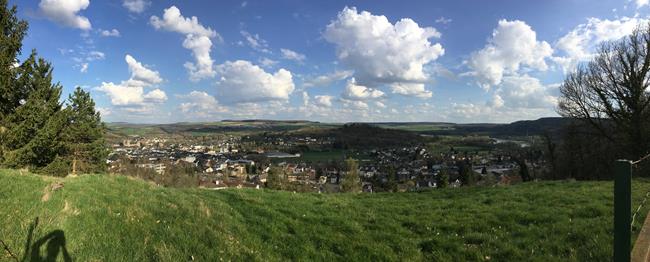
Le Mullerthal, aussi connu comme la Petite Suisse Luxembourgeoise, est une région Luxembourgeoise magnifique, un véritable paradis pour le randonneur expérimenté.
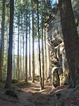
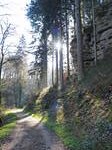
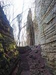
Le sentier Mullerthal Trail vous emmène sur 112 km de sentiers naturels en vallées, passant par des formations rocheuses impressionnantes, des châteaux, des vues panoramiques et des collines ondulées. Impressionnant c'est LE mot qui le décrit le mieux.
Le trail est divisé en parties réalisable:
La route 1 (38 km) vous montrera les sites culturels ainsi que des forêts, prés et champs, et bien sûr formatiosn rocheuses.
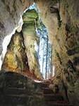
La route 2 (37 km) est le summum pour les amateurs de roches escarpées, roches bizarres, roches spectaculaires, ravins: la route 2, c'est top (de la roche)!
La route 3 (37 km) est obligatoire pour les fans de châteaux romantiques et ... des roches, c'est évident.
Les 3 routes peuvent être connectées pour former une route bien longue. Elle peut encore être prolongée avec un ou plusieurs ExtraTours: ExtraTour A (22 km), ExtraTour B (13 km), ExtraTour C (9 km) et finalement ExtraTour D (31.5 km, un trail en soi).
Cette randonnée traverse la plus spectaculaire des 3 routes principales: une attaque en ligne directe (euh, bwof) sur les 37 km de la route 2, avec forte suggestion d'inclure les 2 extensions. La première étend la randonnée au Sud où ExtraTour C est ajouté. La deuxième extension au Nord est une promenade locale: B2, une expérience à 5 étoiles qui m'a complètement surpris et étonné (j'étais aussi simplement perdu là, la première et seule fois sur le trail). |
Votre mission, si vous choisissez de l'accepter, est de couper le trail en parties réalisables pour vous et votre groupe, trouver une table et un lit, et on y va. La cache vous oblige de commencer le trail à Consorf-Millen, un petit parking près de Consdorf.
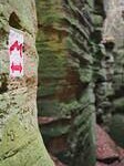
Une fois toutes les préparations faites, il est temps d'aller trouver une cache. Le nombre de waypoints est très limité, les waypoints sont tous résistant au temps, ou ils devraient l'être. Si vous trouvez un en défault, merci de m'informer (de préférence avec une photo).
Chaque waypoint produit une chiffre. Dans la collection des 4 premières chiffres (code A, B, C, D) il y a une certaine redondance mais pas pour les 3 dernières chiffres (code E, F, G). Les 2 extensions (promenade B2 et ExtraTour C) sont en fait facultatives, mais en cas où ils sont inclus dans le trail, il y a 2 chiffres supplémentaires à trouver (code R, S), et donc une redondance supplémentaire et une facilité d'esprit pour les 3 dernières chiffres. Code Q on n'a pas vraiment besoin, mais peut servir comme une vérification basic à la fin.
La boîte (style ammobox) se trouve pas trop loin de Consdorf-Millen, les coordonnées devraient être calculées le moment que vous avez trouvé le dernier code et donc sur le parking (sauf si vous voulez quelques kilomètres supplémentaires dans vos jambes après une randonnée de 50 km).
Comme avec les meilleurs caches de rando la mission n'est pas complexe, c'est surtout l'expérience du voyage lui-même qui est l'objectif principal de cette cache. Il n'est probablement pas trop difficile de trouver les coordonnées de la cache assis à votre bureau, à Mr Google. OK pour moi, mais s'il vous plaît ne vous gloriez pas: il n'y a pas d'honneur dans ce mode d'opération, et ne montre aucun respect pour le CO, ni pour le sentier merveilleux que vous manquerez. Mais allez-y si vous le devez. Voilà, j'ai dit. :-)
Par exemple: j'ai fait la randonnée seul. J'ai garé la voiture à Consdorf-Millen le matin du premier jour. Puis, je marchais la partie sud jusqu'à Echternach où j'ai passé une soirée relaxante dans la ville avec dîner sur une terrasse à la place du marché. Une douche et un lit m'attendaient dans un hôtel discret à proximité. Le lendemain matin, j'ai attaqué la partie nord jusqu'à Consdorf-Millen et je me suis perdu le long de la promenade B2 près de Berdorf. Le trail coupé en 2, et y compris les extensions optionnelles et les petites promenades touristiques autour des sites les plus spectaculaires, les parties sont d'environ 25 km, sans compter les épisodes perdus. Sans les extensions facultatives, la randonnée suit l'itinéraire officiel de la Route 2, atteignant environ 40 kms au total (mode touristique).
Impressions
Merci à ma chère épouse pour le support et l'encouragement.
|
 |
 |
EN
|
The Mullerthal, sometimes referred to as Little Switzerland, is a magnificent region in Luxemburg that is like heaven to the experienced hiker.
The Mullerthal Trail takes you along 112 km of valley trails, rock formations, castles, panoramic views and undulating hills. Breathtaking is THE word that comes to mind.
The trail is chopped into digestible chunks:
Route 1 (38 km) alternates cultural highlights with woods, pastures and rock formations.
Route 2 (37 km) is top of the bill for fans of steep rocks, weird rocks, spectacular rocks, and some ravines: route 2 really rocks!
Route 3 (37 km) is a must for the suckers for romantics castles and ... well some rocks obviously.
All 3 routes can be connected into a long hike and can also be extended with one or more ExtraTours: ExtraTour A (22 km), ExtraTour B (13 km), ExtraTour C (9 km) and finally ExtraTour D (31.5 km, a trail in itself).
This hike trails the most spectacular of the 3 main routes: a brute force attack on Route 2's 37 kilometers, and strongly suggests 2 extensions. The first extends the hike in the South where we split off to ExtraTour C. The second extension in the North part is a local walk: B2, a 5 star experience that left me lost for words (and also just plainly lost, the first and only time on the Mullerthal trail). |
Your mission, should you choose to accept it, is to chop up the trail into chunks digestible to you and your party, find a place to eat and sleep, and get going. This cache requires you to start the trail in Consdorf-Millen, a small parking lot just outside Consdorf.
Once all preparations are done and you're good to go, it's time to go find a cache. There are a very limited number of waypoints, all most probably wear-and-tear proof, or that's the idea anyway. Should you find one that's not there anymore, please inform me of the issue (preferably with a picture added).
Each waypoint yields a number. There is some redundancy in the basic set of numbers along the trail (code A, B, C, D), except for the last 3 numbers (code E, F, G). The 2 extensions (walk B2 and ExtraTour C) are actually optional, but if you include them in your trail, there's 2 extra numbers (code R, S) to be found, giving you some extra redundancy and ease of mind for the last 3 numbers. You don't really need code Q, but it can serve you as a basic check when all codes have been found.
The stash (a juicy ammobox) is located not too far from Consdorf-Millen, its coordinates should be calculated once you've found the last waypoint and not at the carpark (unless you like a few extra kms in your legs after a 50 km hike).
As allways with the best trailcaches the mission isn't complex, it is the experience of the journey itself that forms the objective of this cache. It most probably is not too difficult to find the cache location while sitting at your desk talking to Mr Google. Fine by me, just don't brag about it: there's no honour in that modus operandi, and shows no respect for the CO, nor for the wonderful trail you would be missing out on. But go ahead if you must. Voilà, had to get this out of my system. :-)
As an example: I hiked solo, parked the car at Consdorf-Millen on the morning of the first day. Then hiked the South part to Echternach where I had a relaxing evening lounging through town and having dinner on a terrace at the market square. Shower and bed was waiting for me in a nice, low-key hotel nearby. The next morning I hiked the North part back to Consdorf and got lost along the B2 walk near Berdorf. Chopped up into 2 parts, including the optional extensions and little strolls around the most spectacular sites, both stints are about 25 kms, not including getting-lost episodes. Without the optional extensions the hike follows the official Route 2 trail, coming in at about 40 kms in total (tourist mode).
Impressions
Thanks to my wife for her support and encouragement.
|
 |
 |
ROUTE
Le fichier GPX de l'itinéraire et des différents points intéressants vous trouvez ici.
The GPX file of the itinerary can be found here.
SOS
SMS between 9h & 21h only please

Questions
WP00 - code Q - N49° 46.777' E6° 19.678'
Quel est le plan de base de cette structure?
What is the basic groundplan for this structure?
Quadrilatéral / Quadrilateral => Q = 1
Hexagone / Hexagon => Q = 2
Octagone / Octagon => Q = 3
Q = ____
WP01 - code A - N49° 46.711' E6° 19.634'
Quel animal est représenté centralement sur le pilar?
What animal is depicted centrally on the pilar?
Lion => A = 7
Oiseau / Bird => A = 5
Elephant => A = 3
A = ____
WP02 - code B - N49° 45.522' E6° 19.339'
Trouvez l'année au-dessus de l'entrée. B est la somme réduite de tous les chiffres composant cette année. Par exemple. Si ANNEE = 1862, la somme réduite = 1 + 8 + 6 + 2 = 17 = 1 + 7 = 8.
Find the year above the entrance. B is the reduced sum of all digits in that year. E.g. if YEAR = 1862 then the reduced sum = 1 + 8 + 6 + 2 = 17 = 1 + 7 = 8.
B = ____
WP03 - Backup code A - N49° 45.167' E6° 19.667'
Attention: si vous choisissez de suivre ExtraTour C, c'est ici qu'il faut quitter Route 2!
Attention: if you choose to follow ExtraTour C this is the place where you need to break off of the Route 2 trail!
Quelles lettres voyez-vous sur la grille de la petite chapelle?
What letters do you see on the railing of the little chapel?
P + X => A = 7
A + M => A = 5
M + C => A = 3
A = ____
WP04 - Extra code R via ExtraTour C - N49° 44.924' E6° 21.122'
Combien de niches à gauche et à droite vous rencontrez en marchant dans le tunnel?
How many recesses left and right do you encounter while walking through the tunnel?
R = ____
WP05 - code C - N49° 46.418' E6° 21.500'
Trouvez les trois amis colorés Poos, Erny et Fred. Lequel n'est PAS né dans la même année que les deux autres?
Find the 3 colorful friends Poos, Erny and Fred. Which one was NOT born (né) in the same year as the other 2?
Poos => C = 0
Erny => C = 1
Fred => C = 2
C = ____
WP06 - Backup code B - N49° 46.829' E6° 21.428'
Nous retrouvons le même Fred, et nous trouvons aussi son visage. Nous savions déjà sa naisssance, trouvez maintenant l'année que Fred est mort.
Trouvez la somme réduite de tous les chiffres figurant sur la plaque. Par ex si les 2 années sont 1971 et 2015 alors la somme réduite = 7 + 9 + 1 + 1 + 2 + 0 + 1 + 5 = 26 = 2 + 6 = 8.
Here we find the same Fred again, and we also find out how what he looked like. We already knew when he was born, now find the year that Fred died.
Find the reduced sum of ALL the digits mentioned on the plate. E.g. if the 2 years are 1971 and 2015 then the reduced sum = 1 + 9 + 7 + 1 + 2 + 0 + 1 + 5 = 26 = 2 + 6 = 8.
B = ____
WP07 - Backup code C - N49° 48.848' E6° 24.877'
Trouvez l'année 19XY au-dessus de l'entrée.
Find the year 19XY above the entrance.
C = Y - X
C = ____
WP08 - code D - N49° 48.970' E6° 24.093'
Trouvez l'année 19XY sur la plaque commémorative sur le mur opposé en sortant la gorge. Astuce: prenez une photo puis zoomer dessus, ça va seul.
Find the year 19XY on the memorial plate on the opposite wall when walking out of the Schlucht. Hint: take a picture and then zoom in on it, you're not THAT Eagle-eyed.
D = 2 * (X + Y)
D = ____
WP09 - Backup code D - N49° 48.923' E6° 21.531'
Trouvez l'année 19XY sur la plaque commémorative "ZUR ERINNERUNG AN DIE HAUPTVERSAMMLUNG ..."
Find the year 19XY on the memorial plate "ZUR ERINNERUNG AN DIE HAUPTVERSAMMLUNG ..."
D = X + Y (attention: en case de doute/in case of doubt: X > Y)
D = ____
WP10 - Vers/to promenade B2 - N49° 49.383' E6° 20.875'
Attention: si vous choisissez de suivre l'extension B2 c'est ici qu'il faut quitter Route 2!
Attention: if you choose to follow extension walk B2 this is the place where you need to break off of the Route 2 trail!
Plus d'info sur promenade B2 ici
More info on walk B2 here (it's in French)
WP11 - Extra code S via promenade B2/ Ile du Diable / Teufelsinsel - N49° 49.546' E6° 20.323'
Suivez promenade B2 et cherchez 'Ile du Diable / Insel Teufel' (c'est peut être un défi, si vous trouvez le Totenkammer vous êtes très proche).
Beaucoup d'âmes romantiques ne pouvait que signer un pacte avec le diable ici pour garantir l'attention de leur grand amour. Trouvez l'année XYZS dans laquelle MAUD et PIET ont signé leur pacte.
Following walk B2 find your way to 'Ile du Diable/Teufelsinsel' (this may be a challenge, if you found the Totenkammer you're very close).
A lot of romantic souls couldn't help but sign a pact with the devil here to ensure the attention of the love of their lives. Find the year XYZS in which MAUD & PIET signed their pact.
S = ____
WP12 - Reconnection B2 / Route 2 - N49° 49.448' E6° 20.318'
WP13 - code E - N49° 49.412' E6° 20.290'
Quelle est la profondeur de l'Enfer? Réponse: EE mètres.
How deep is Hell (Enfer)? Answer: EE metres.
E = ____
WP14 - code F - N49° 47.495' E6° 18.723'
Sur le pont en bois, regardez le second pont (privé) à votre droite. De quel type est ce pont?
Standing on the wooden bridge, look at the second (private) bridge to your right side. What type is this bridge?
- Ce n'est rien de plus qu'une poutre en bois et une corde / It's nothing more than a beam and a rope => F = 2
- C'est une dalle de béton plane / It's a flat concrete slab=> F = 3
- C'est une arche en pierre / It's a stone arch => F = 4
F = ____
WP15 - code G - N49° 46 . (A + F) (E) (B)' E6° 18 . (A + C + F) (E) (E - F)'
Allez explorer les couloirs et trouvez la Belle Vue en haut. Vous verrez trois sœurs, que sont-elles?
Go explore the corridors and find the Belle Vue on top. You'll see 3 sisters, what could these sisters be?
- Passerelle / Footbridge => G = 3
- Monolithe / Monolith => G = 2
- Banc / Bench=> G = 1
G = ____
C'est fait, asseyez-vous et n'attendez pas de calculer les coordinnées de la finale. Vous y êtes presque.
All set, have a seat and don't wait to calculate the final coordinates. You're almost there.
Stash
Extra codes:
Q = la somme réduite de / the reduced sum of A, B, C, D, E, F, G, R, S
R = A - B + E + G
S = E + F
N49° 46 . (F + G) (B) (C) '
E006° 18 . (E + G) (D) (A) '