La Mina Waterfall Earthcache
NOTE: Entrance to el Yunque forest is totally free of charge except if you are interested on visiting El Portal area which is open all days from 9:00am to 4:30pm. You dont need to visit El Portal to do the trails or to complete this Earthcache
The El Yunque National Forest is the only tropical rain forest in the national forest system. It’s located in northeastern part of Puerto Rico. At nearly 29,000 acres, it is one of the smallest in size, yet one of the most biologically diverse of the national forests hosting hundreds of animal and plant species, some of which are found only here.
The forest is commonly known as El Yunque, which may be attributed to either a Spanish approximation of the aborigine Taino word yu-ke which means "white lands", or the word “anvil”, which is yunque in Spanish.
And as a rain forest, water is one of the elements that predominate in this forest. There are few waterfalls that you can observe during your visit to the park: La Coca, La Mina, Juan Diego Falls, etc. This earthcache is about La Coca.
A waterfall is a place where water flows over a vertical drop or a series of drops in the course of a stream of river. Waterfalls also occur where meltwater drops over the edge of a tabular iceberg or ice shelf
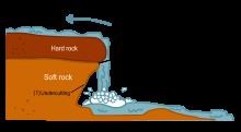
Waterfalls are commonly formed in the upper course of a river. At these times the channel is often narrow and deep. When the river courses over resistant bedrock, erosion happens slowly, while downstream the erosion occurs more rapidly. As the watercourse increases its velocity at the edge of the waterfall, it plucks material from the riverbed. Whirlpools created in the turbulence as well as sand and stones carried by the watercourse increase the erosion capacity. This causes the waterfall to carve deeper into the bed and to recede upstream. Often over time, the waterfall will recede back to form a canyon or gorge downstream as it recedes upstream, and it will carve deeper into the ridge above it. The rate of retreat for a waterfall can be as high as one and half meters per year. Waterfalls can be grouped into ten broad classes based on the average volume of water present on the fall (which depends on both the waterfall's average flow and its height) using a logarithmic scale. Class 10 waterfalls include Niagara Falls, Paulo Alfonso, etc.
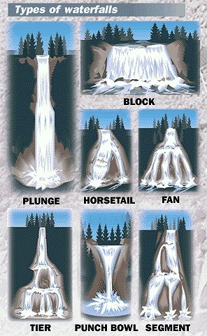
There are different types of waterfalls classified by how the water descends and contacts the underlying rock.
Block: Water descends from a relatively wide stream or river. Water descends a series of rock steps.
Fan: Water spreads horizontally as it descends while remaining in contact with bedrock.
Horsetail: Descending water maintains some contact with bedrock.
Plunge: Water descends vertically, losing contact with the bedrock surface.
Punchbowl: Water descends in a constricted form, then spreads out in a wider pool.
Segmented: Distinctly separate flows of water form as it descends.
Tiered: Water drops in a series of distinct steps or falls.
To claim this earthcache you will need to visit the coordinates. You must send an email with the answers to the following questions before logging the found. A photo at the final coordinates is optional but will help. I will let you know if there are any mistakes in your answers:
- How are the waterfall commonly formed?
- How many classes exist? Which class will applies to La Coca Falls.
- Mention some of the types of waterfalls. Based on definition, this falls is which type of waterfall.
- There are some warning signs in this area. Mention two of them.
Information collected from:
Wikipedia and http://tehcc.org/wiki/Category:Waterfalls