Eli Creek is the largest freshwater stream on the eastern coast of K'gari, with over four million litres of water flowing from its mouth onto the beach and into the ocean every hour. It is considered to be one of Fraser Island's most popular natural wonders. Located a few kilometres north of Happy Valley, Eli Creek has Scenic board walks that have been erected along the banks for visitors to view the creek, it is also a popular swimming area for children and adults alike.
Eli Creek Begins as a spring high in the central sand dunes. More water seeps from the sand mass, adding to the constant flow. Surface water is often stained brown by plant tannins. As this water passes down through yellow-brown sands, organic matter is removed, leaving crystal clear water as it flows into the sea.
Aspects of K'gari's Fresh Water
K'gari has an abundance of fresh water. Sand dunes are great reservoirs of fresh water. In the saturated layers of sand, (the water table) spaces between the grains enable water to occupy about a third of the volume
Water Repellence: Sand should be as porous as a sponge, however dry sand on Fraser Island tends to repel water. This result of organic material in the sand. Water seems to roll off dry sand rather than be absorbed by it. Water seems to roll across the top of the sand surface and dry sand grains cling to the drops until the repellence finally breaks down. During this repellent stage, significant surface erosion occurs. It is worse on disturbed areas. To reach the underground water table, rain and runoff water has to pass through the various layers of soil. In this process, many chemical changes take place which affect its colour and chemical properties. Most of these occur in the “B” Horizon in the soil profile.
.
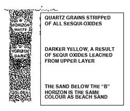
The “B” Horizon: Beach sand grains have a distinctive sandy colour. This is because white quartz silica grains are covered with a fine film of sesqui-oxides. These are derived from iron. Over time the sesqui-oxides are stripped from the surface sand and become concentrated deeper down in the soil profile (the “B” Horizon). Thus, the surface soil becomes white (unless discoloured grey by humus). This is the “A” horizon. The sand below becomes deeper yellow. The colour of the “B” horizon becomes darker the deeper it occurs in the soil.
.
Nutrients in the “B” Horizon: The sesqui-oxides carry powerful negative charges. These attract and hold any positive ions in the soil. Since essential plant nutrients such as phosphate and potash are positively charged ions, the “B” Horizon contains is critical to plant nutrition. The “B” horizon also contains a small amount of aluminium.
.
"Black" Water: Surface water may be coloured by organic material. Although the organic material gives water a reddish or tea colour. This has no bearing on its drinking quality. Scientists describe this organically discoloured water as "black". (Examples: Lake Boomanjin, Bogimbah Creek)
.
"White" Water: When water percolates through the ground, the organic colloids (which dries out to fine black dust). These colloids react with minute fractions of aluminium in the “B” horizon and are precipitated out. After losing all the organic colloids in the “B” horizon the water becomes clear. It is known as "white" water. (Examples: Lake McKenzie, Wanggoolba Creek).
.
Blended Water: Some surface water may be a blend of both black water and white water when new organic material is added after water has already been through the “B” horizon. (Examples: Ocean Lake and many creeks.)
.
Nutrient enrichment: As water passes through the "B" horizon where the aluminium is concentrated, it collects some of the precious plant nutrients held there. Thus when the groundwater emerges in springs and streams, it is clear and slightly richer. Thus, much “white” water will have nutrients and minerals not found in rain water. This is evident by the lusher vegetation growing near springs and streams such as Eli and Wyuna Creeks.
.
Organic Precipitation in Lakes: “Black” water can be made “White” without necessarily passing through the “B” horizon. While standing in the lakes small quantities of aluminium in the lake bed is also precipitating out organic colloids. These then sink to the bottom of the lake and add to the humus seal which forms the bed of the lake. The “coffee rock” such as is found at Poyungan and Yidney Rocks represent the material typical of lake beds. This is just sand (silica) grains bound by the Lakes such as Lake McKenzie are filled with “white” water. However, that water lacks the nutrients found in the springs and streams because it hasn’t passed through a “B” horizon.
.
Chemical Purity: The water in the freshwater lakes, particularly the perched lakes, is of special quality. Because it missed the nutrient dose from a “B” horizon it lacks a number of basic ions. This results in them having some of the chemically freshest water to occur in any natural water bodies in the world. Using soap containing phosphates will change the chemical properties of the water and degrade one of the World Heritage values of Fraser Island. Particular care needs to be taken to avoid adding anything to the water which contains phosphorus.
.
The Water table: Water is stored in the aquafers of the regional water table and lakes. The regional water table may emerge springs to form large streams such as Bogimbah or Eli Creeks. Where the water table rises above the land surface as at Ocean or Wabby Lakes these lakes become "windows” in the water table. These have a higher level of phosphate in them than "perched" dune lakes.
.
Age of Water: As a general rule black water, representing mainly surface runoff is relatively young and white water is older. Scientists have traced radioactive isotopes released by nuclear testing in Australia in the 1950's in the white water emerging in springs. This revealed that the white water emerging from Cooloola’s dunes in springs Island was about 80 years. On that basis, the mean residence time of Fraser Island water in the dunes would exceed 100 years. It may therefore take 200 years for some water to emerge.
Logging requirement:
To Log this EarthCache, please send an email with answers to the following questions to our Geocaching.com account.
1. Your caching name and the EarthCache name
2. At the listed Co-ordinates, what are the predominant plants that you see? if you are unsure of their name check the information board at the Trail head waypoint. Why do you think this vegetation is present at GZ?
3. Of the 3 different types of water listed above, what do you think Eli Creek is?
4. Now listen to the Creek, what can you hear? And why do you think the creek sounds like this? This one could be a little hard if you are there on a busy human day, but ignore the human sounds, and listen to the Creek.
5. If you would like include a photo of yourself at GZ, but please don’t include a picture of any of the questions as we will need to delete the photo.
Sources:-
http://fido.org.au/moonbi/backgrounders/18%20Water%20Quality%20and%20Lakes.pdf