Cuave del Milodon
Task
To log the cache, send me the answers to the following question.
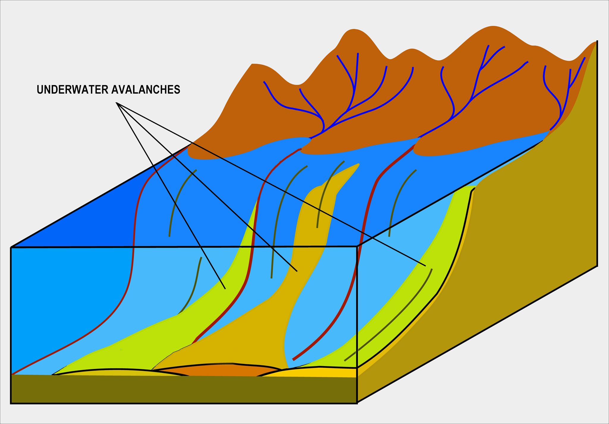
1. How are these submarine avalanches and their deposits/stone called?
2. Why are the three caves in this area, are all on the nearly same level?
3. How could the age of the prehistoric lake and its different levels be dated? Describe in detail.
Picture is necessary and should show that you have been at the earthcache with at least your geocaching name or yourself in the picture.
Geology
The sedimentary formations around the Cueva del Milodón in Chile are intricately linked to underwater avalanches. Traces of past events are normally hard to track down. Especially if they happened over 80 million years ago. Let's explore how these events unfolded and created the landscape we see today.
What does it need, that we today know, what has happened:
- A delta of a river bringing a lot of sediments, that deposits at the estuary
- A underwater cliff or canyon nearby
- A submarine avalanche
- A complexe chemical process forming binding the stones and sediemnts to a new rock
The sea at that time was called Magellan Basin and was up to 2000-3000m deep. This is now the ground you are standing on. Over time this floor gets to stone and experienced an tectonic uplift.
Upon the layers scientist can tell about the age and the way they came to existence.
Landscape
An important role in todays apperance is played by Glacial Activity. During the Pleistocene epoch, the region experienced extensive glaciation, with large ice sheets covering much of the landscape. Glacial erosion and deposition further shaped the terrain, influencing the formation of glaciers and lakes and its surrounding features. If you are interested in discovering glacial features and naming them I recommend to check out the Earthcache in Torres del Paine about glacial landforming https://coord.info/GC10ZEZ.
Caves
The caves are about 150 meters above sea level, which hasn't changed much in the past million years. So the next factor of erosion might come as a surprise.
Coastal erosion: The glaciers retreated and expanded severall times in the past. The connection to the sea is rather small. It is thought, that the glaciers or/and their broken off ice blocked the way to the sea and created a lake. This was in a time between 14.000-12.000 years ago.
The level of the lake wasn't always the same at varied. That caves came to existence was also due to layering of the stone. Each layer had a certain resistance to stone, making some layers easier to erode.
Dating of the caves was possible through a mixture of C14 dating (only possible for organic material) and logic.
 Cuave del Milodon
Tarea
TPara registrar el caché, envíeme las respuestas a las siguientes preguntas.
1. ¿Cómo se denominan estas avalanchas submarinas y sus depósitos/piedras?
2. ¿Por qué las tres cuevas de esta zona están todas casi al mismo nivel?
3. ¿Cómo se podría datar la edad del lago prehistórico y sus diferentes niveles? Descríbalo con todo detalle.
La foto es necesaria y debe mostrar que has estado en el earthcache con al menos tu nombre de geocaching o tú mismo en la foto. .
Geología
Las formaciones sedimentarias que rodean la Cueva del Milodón, en Chile, están estrechamente relacionadas con las avalanchas submarinas. Las huellas de sucesos pasados suelen ser difíciles de rastrear. Sobre todo si ocurrieron hace más de 80 millones de años. Exploremos cómo se desarrollaron estos acontecimientos y crearon el paisaje que vemos hoy.
Qué necesita, que hoy sepamos, lo que ha sucedido:
- Un delta de un río trayendo muchos sedimentos, que se depositan en el estuario
- Un acantilado o cañón submarino cercano
- Una avalancha submarina
- Un complejo proceso químico que une las piedras y sedimentos en una nueva roca
El mar en ese momento se llamaba Cuenca de Magallanes y tenía hasta 2000-3000m de profundidad. Este es ahora el suelo sobre el que estás parado. Con el tiempo este suelo se convirtió en piedra y experimentó un levantamiento tectónico.
Sobre las capas los científicos pueden decir la edad y la forma en que llegaron a existir.
Paisaje
La actividad glaciar desempeña un papel importante en el aspecto actual. Durante el Pleistoceno, la región experimentó una extensa glaciación, con grandes capas de hielo que cubrían gran parte del paisaje. La erosión y deposición glaciares modelaron aún más el terreno, influyendo en la formación de glaciares y lagos y en las características de su entorno. Si te interesa descubrir rasgos glaciares y ponerles nombre, te recomiendo que eches un vistazo al Earthcache de Torres del Paine sobre la formación del relieve glaciar https://coord.info/GC10ZEZ.
Cuevas
Las cuevas están a unos 150 metros sobre el nivel del mar, que no ha cambiado mucho en el último millón de años. Así que el siguiente factor de erosión puede resultar sorprendente.
La erosión costera: Los glaciares retrocedieron y se expandieron varias veces en el pasado. La conexión con el mar es bastante pequeña. Se piensa, que los glaciares o/y su hielo quebrado bloquearon el camino al mar y crearon un lago. Esto ocurrió hace entre 14.000 y 12.000 años.
El nivel del lago no fue siempre el mismo a variado. Que surgieran cuevas también se debió a la estratificación de la piedra. Cada capa tenía una resistencia determinada a la piedra, por lo que algunas capas eran más fáciles de erosionar.
La datación de las cuevas fue posible gracias a una mezcla de datación por C14 (sólo posible para material orgánico) y lógica.