Wilderness Mouth River Banks Earth Cache
Welcome to the Wilderness River one of the most Special & Beautiful places to us. Every moment shared here is a complete privilege. Trust you able to soak up and enjoy any bit of the beauty you can and that is the most important thing about all our caches in Wilderness.
This forms part of our Garden Route Earth Cache River Series and various of our other Garden Route Icon series.
The intended value of this particular Earth Cache is to firstly share some the magnificence and stunning tranquillity of the area and spot. Secondly to learn a bit about rivers and how different of their processes and elements work. Thirdly to grasp the importance of preserving an Eco system.
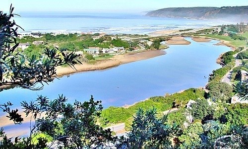
Below are aerial pictures of the Wilderness Mouth and Upper region of the river:


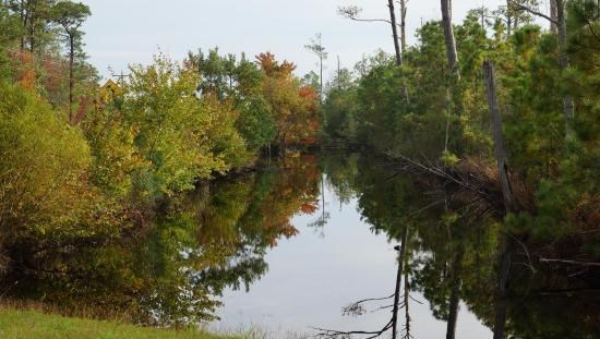
River Water Nutrients and Minerals
When looking at the colour of water, it is important to note the difference between the apparent colour and true colour of a body of water. The apparent colour is the colour of the water when looking at it without removing any suspended and dissolved particles. Despite conventional wisdom that those clear, blue waters we have mostly come to cherish for so long may are not the pinnacle of pristine at all.
True colour is the colour of the water after the suspended particles have been removed. Suspended particles are things such as algae, sediments, or small particles of a mineral. Dissolved particles are things such as tannins (a yellowish-brown organic acid that is found in plant tissues), or particles of iron and manganese from rocks or soil. Water that is blue has a very low amount of dissolved particles in it.
Factors of the colour such as minerals, soil runoff and sediment, and even algae can cause water to vary from its natural colour of blue. The most common cause for water to change colour is minerals. Water running over roots extracting minerals changes the colour. When a rock is weathered down over time, the minerals from the rock are dissolved and small pieces are released into the water causing different colours.
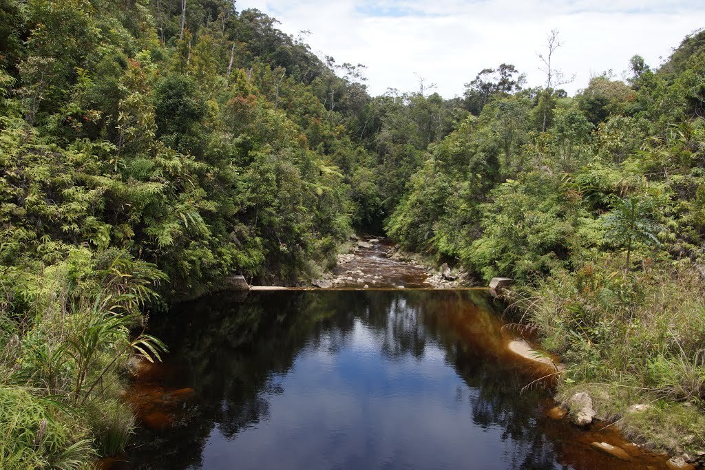
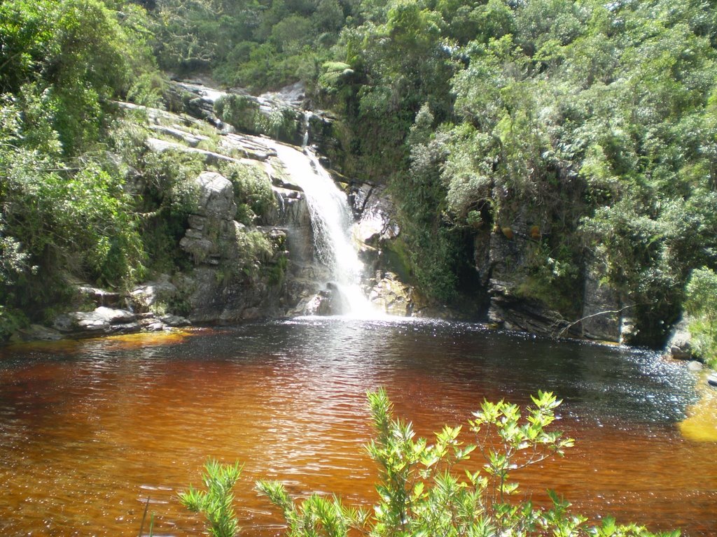
Iron, manganese, and calcium carbonate from limestone all common minerals that can cause water to range in colour from red and orange to green and blue. Red and brown colors tend to be due to iron; black to manganese or organic matter; and yellow to dissolved organic matter such as tannins brownish coca cola looking colour due to Iron and manganese which are common. There are various home tests that can be done like the pool tests in order to determine the percentage of each of the minerals in the water.
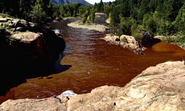
Sediment and soil runoff can also change water’s colour. Sometimes as a temporary colour change after storms and sometimes permanently if the river constantly carries lots of sediment. Erosion from river banks brings soil into the river, changing the colour. After heavy storms, many rivers run brown from all the runoff flowing into the river. Clay can cause rivers to be murky whiteuddy brown, or yellow.
The coloured water due to minerals has significantly positive effects on aquatic plants, marine and bird life. The variances are good for the balancing of different ecosystems and preserving their uniqueness.
Bank Erosion
It is the wearing away of the banks (sides) of a stream or river. This is distinguished from erosion of the bed of the watercourse (river floor), which is referred to as scour.
Erosion occurs drastically in the upper parts of the river where the river is narrower, the gradient is steeper and the overall speed of the water is much fast with the water rushing through narrower spaces. Examples of this is where the soil on the sides of the river have sheer drops. With the speed of the water being faster higher upstream the impact is greater putting more pressure on the banks.
Erosion occurs more gradually further downstream where the gradient is shallower, the river surface is wider and the speed of the water is slower and therefore the water flows more gently. The impact on the river banks is drastically reduced with less pressure on the banks but over time there can still be significant shifts in the river banks. This is where there is a prevalence of meanders occurring. The following nearby earth cache is in our Garden Route river mouth series covers this topic more for those who are interested:
Vegetation Impact
Vegetation can have a significant impact to reduce bank erosion. River banks with vegetation erode much slower than those without. Dense vegetation growing on the bank face can deflect flowing water and prevent fluvial erosion. Roots generally increase the strength of bank material, making a bank less prone to mass failure. However, trees can also add significant weight to the tops of stream banks and may actually decrease stability.
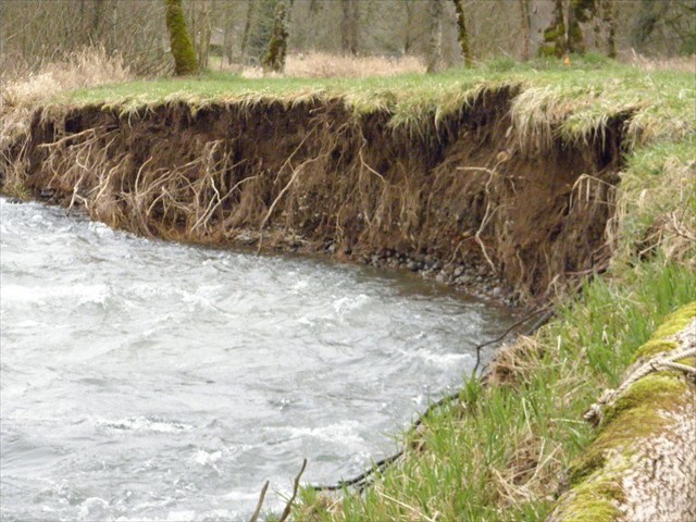
The roots of vegetation growing along the river have various different forms of positive impact on the banks according to the variables. As the roots bind the soil tightly, they form abutments which jut out over the water. These have a significant effect upon the rate and progress of the erosion.
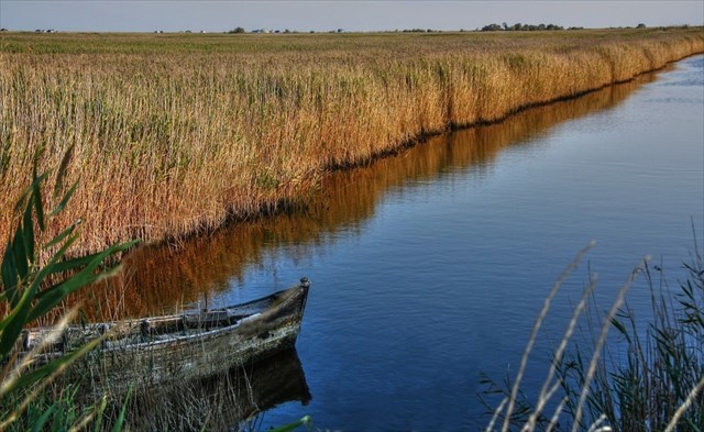
Vegetation that is dense in nature acts like a catchment to the silt already in the water and the exposed root structures even more so like a sieve. That is where the double action comes into play where the vegetation firstly not only slows the erosion down in numerous ways but because of the sieve nature of the vegetation it catches silt already in the water and in builds the river bank back up again. Some of the helpful tightly woven vegetation are reeds, sedge grass, bulrushes, vynbos and firs.
Measuring Erosion
There are a variety of methods for measuring river bank erosion rates. A direct method is to insert metal rods (called "erosion pins") into the bank and marking the position of the bank surface along the rods at different times. This simple measurement technique can be enhanced with the use of a data logger attached to a rod of photoreceptors; the logger records the voltage, which is an indication of how much of the rod is exposed. Another common method is to survey a stream cross section repeatedly over time. This measures the erosion rate in addition to changes in the geometry of stream banks. Aerial and satellite imagery can be used to measure rates of bank erosion and river channel migration at larger spatial scales by comparing bank locations at various times. Finally, there are a variety of less common methods like using sedimentology or tree age to calculate erosion rates by approximating historic locations of the river channel.
Mechanisms
There are two primary mechanisms of stream bank erosion: fluvial erosion and mass failure. Fluvial erosion is the direct removal of soil particles by flowing water. The rate of fluvial erosion is determined both by the force of the flowing water (e.g. faster flow equals more force) and the resistance of the bank material to erosion (e.g. clay is generally more resistant to erosion than sand). Mass failure occurs when the weight of a stream bank is greater than the strength of the soil, causing the bank to collapse. This process is dependent upon a number of factors including the internal strength of the soil (e.g. clay vs. sand), soil-water content, and vegetation. These two erosion processes are linked as fluvial erosion of the bottom of the bank creates a steeper bank angle or overhanging soil blocks which are more unstable and likely to collapse.
Other erosion processes include cycles of wetting and drying or freezing and thawing which weakens the bank soil and makes it more susceptible to erosion. An additional form of erosion is termed seepage erosion. This occurs when groundwater flows out of a stream bank with enough force to erode the bank material. If concentrated, seepage erosion can be called piping because a “pipe” of soil is eroded.
Vegetation acts as an interface between the elements and the soil. The roots of the plants bind the soil together, and interweave with other roots, forming a more solid mass that is less susceptible to erosion. The removal of vegetation increases the rate of erosion. Preserving the fine balances in the ecosystem is critical.
Above all the most important thing is to do just that to maintain the balances in the eco system that support the life of the plants, birds, fish, animals and organisms. This is the main goal of looking after and preserving our river systems.

Sedgefield Mouth Questions
Please take a picture at your favourite spot anywhere near the mouth either side of the Coordinates or along the river and upload in your Log. Please share a picture so everyone can enjoy the collection.
We have kindly provided all the answers for you in the listing. Please return the favour by sharing your answers in your words what your thoughts and understanding is and share some general knowledge through the way you answer and please do not to stress about submitting the answers. The aim of this earth cache is to enjoy and learn.
1 What do you notice about the colouration of the water, and what do you think the reason for this is?
2 What minerals are in brownish Coca Cola like coloured water?
3 What double action and overall effect does the vegetation have on the river bank? Explain what the vegetation does for the actual soil along the bank. You can particularly notice the effect the vegetation has had on the river bank in the little cove you are standing.
4 Why is there more pressure on the river bank in terms of erosion further upriver than downstream closer to the mouth particularly with regard to the speed of the water?
5 What man made feature do you see in the cove at the coordinates on the river bank and what material is it made of? What natural vegetation is predominantly along the river?
Thank you for sharing this area and cache with us. We trust that you enjoyed the Earth Cache and your experience here.
Please have a look at our caching series all along the Wilderness Mouth including the Whereigo caches. They all share a closer experience of the river nature and the environment.