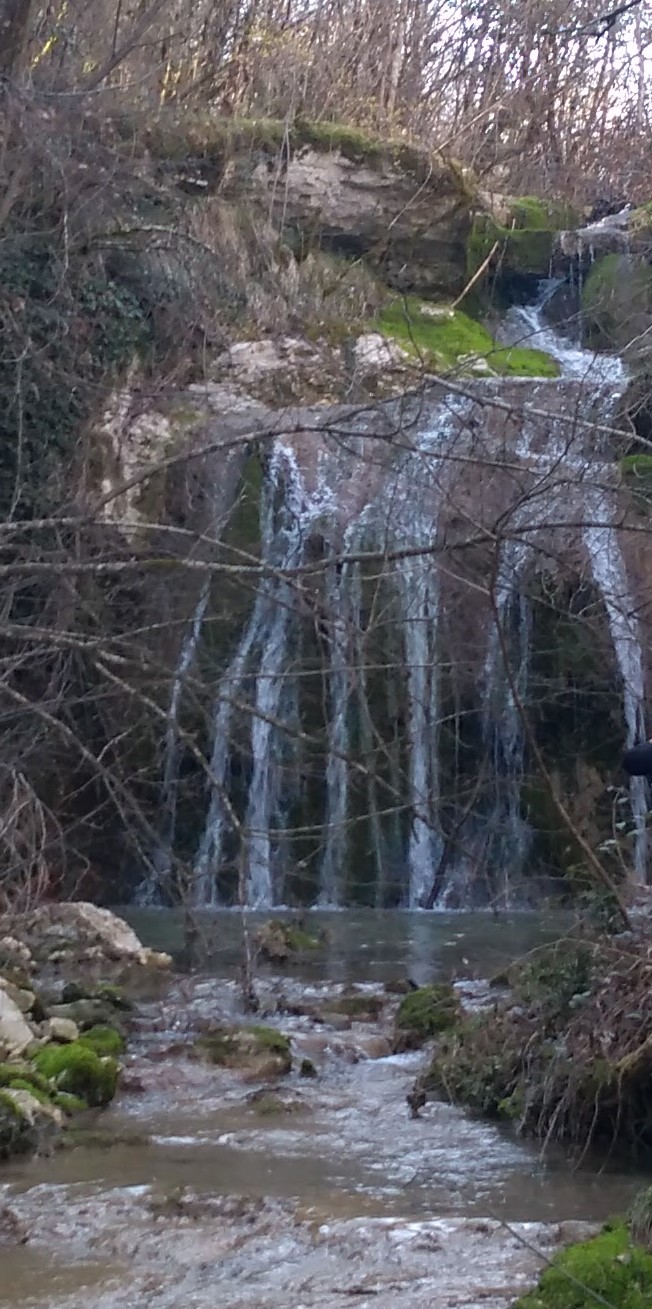

Sedreni slap nalazi se na potoku ispod izvora Malenica. Da ne pišemo puno istražite njegovu ljepotu na samom mjestu. Nalazi se na krškom terenu.
Što je krš?
Krš je skup reljefnih oblika koji su produkti kemijskog trošenja (korozije) stijena topivih u vodi (karbonatne stijene, gips, kamena sol) tj. spektar reljefnih oblika razvijenih u karbonatnim formacijama koje najčešće čine kalcijev (CaCO3) i magnezijev (MgCO3) karbonat.
Obzirom na takav kemijski sastav karbonatne stijene se nazivaju vapnenci i dolomiti, a njihovo svojstvo topivosti u vodi omogućuje stvaranje krša.
Krš je dakle općeniti naziv za skup morfoloških, hidroloških i hidrogeoloških značajki terena koji su izgrađeni od stijena topivih u vodi.
Glavnu ulogu u oblikovanju krškog reljefa imaju kemijski procesi. Dakako da se tu još uključuju tektonika i mehanički procesi, ali bez kemijskih procesa ne bismo govorili o krškome reljefu. Krški je reljef rezultat kemijskoga trošenja stijena Najvažniji uvjet za odvijanje procesa okršavanja jest topivost karbonatnih stijena u vodi. Te stijene doduše izgledaju vrlo čvrsto i otporno, ali voda ih nagriza. To se nagrizanje (kemijsko trošenje, korozija) ne događa na očigled, nego tijekom dugog niza godina.
Sedra
Sedra ili bigar je sedimentna stijena i pripada grupi karbonatnih stijena. Nastaje oko hladnih izvora. Karakteristična je zbog šupljikavosti.
Sedra je monomineralna stijena, što znači da je izgrađena od samo jednog minerala - kalcita. Struktura je kriptokristalasta, dok je tekstura šupljikava. Kada je kompaktna i trakaste građe, naziva se travertin.
Do nesporazuma često dolazi jer postoje i takozvani Vulkanski "tuffs"; to su naspram sedre slabo očvrsnuli vulkanski pepeo.
Ako voda u kršu teče preko tepiha mahovine, tepiha algi ili kolonija cijanobakterija, veća količina vapna može se istaložiti kada organizmi za njihovu asimilaciju (fotosinteze) izvlače iz krške vode ugljični dioksid. Cijanobakterija, nekad se pripisivala plavo-zelenim algama, posjeduje kao mahovine i alge sposobnost obavljanja fotosinteze, za apsorpciju CO2. Izvlačenjem ugljičnog dioksida povećava se pH vode, čime se smanjuje topljivost vapna, vapnenac se istaloži. Karbonatni sedimenat može rasti po stopama od 0,01 mm/godišnje anorganski i do 20 mm/godišnje kod organski induciranim taloženjem.
Istaloženi vapnenac taloži se kao fina kristalna kora uz sve što relativno miruje kao mali materijal (pijesak, kamenje, grane, lišće, paprat, mahovina, sluzave alge, itd). Nastaje formiranjem preko rubova raslojavanjem prema gore i prema naprijed rastuće strukture na malim slapovima ili terasama na potocima. Mahovina raste preko njihove svježe okorjelih djelova oni se ponašaju kao mali lončići i formiraju nosivi okvir. Biološka kontaminacija iz algi i bakterija stvaraju relativno fine strukture. Strukture su porozne i lakše, tako da mahovina može izdržati protoku vode. Takva sedra je često još vlažna i mrvi časte konzistencije. U idealnim vremenima naraste već nakon nekoliko stoljeća u velike strukture takozvane "Sedrene barijere" .
Da bi mogli logirat Earthcache postavit ću Vam nekoliko pitanja, a Vi mi pošaljite odgovore na mail, ne morate čekat moj odgovor već slobodno logirajte, ako nešto nije u redu kontaktirat ću Vas.
1. Promotrite earthcache i opišite prirodu i boju sedrenih naslaga na vodopadu.
2. Koja je razlika između običnih vodopada i sedrenih vodopada, objasnite svojim riječima.
3. Procjenite visinu vodopada, postoji samo jedan ili više sedrenih slapova na mjestu earthcachea?
4. Pogledajte vodopad. Koja biljka mislite ubrzava formiranje ovog vodopada?
5. Što možete vidjeti desno od vodopada u maloj špiljici?
6. Napravite fotografiju sebe (fotografijom na kojima je gps/mobitel, ruka ili noga NE ispunjavate zadatak i log će biti obrisan) ili papira s vašim nikom sa lokacije EC-a te ju stavite u svoj log.
Uživajte u ovom predivnom mjestu!

Der Kalktuff, Wasserfall befindet sich am Bach unterhalb der Quelle Malenica. Moechte nicht viel schreiben so das Sie erkunden die Schönheit dieses Ortes. Er befindet sich auf dem Karstgebiet.
Was ist Karst?
Karst ist eine Sammlung von Geländeformen , die die Produkte der chemischen Verwitterung (Korrosion) von Gesteinen die im Wasser löslich sind (Karbonate, Gips, Steinsalz ), dh Bereiche von Geländeformen in Karbonatformationen entwickelt sind, die in der Regel von Calcium (CaCO3) und Magnesium (MgCO3) Karbonat bestehen.
Aufgrund einer solchen chemischen Zusammensetzung der Karbonate Felsen werden sie Kalkstein und Dolomit genannt, und ihre in Wasser charakteristisch Löslichkeit ermöglicht die Endstechung von Karst.
Karst ist daher ein allgemeiner Name für eine Reihe von morphologischen, hydrologische und hydrogeologisch Merkmale des Geländes, das ausgebaut ist von Felsen die in Wasser löslich sind.
Die Hauptrolle bei der Bildung von Karst Relief sind chemische Prozesse. Es sind da auch noch tektonischen und mechanischen Prozessen, aber ohne chemische Prozesse würden wir nicht über Karst Relief reden. Karst Relief ist das Ergebnis einer chemischen Verwitterung von Gesteinen. Wichtigste Voraussetzung für den Prozess der Verkarstung ist Löslichkeit der Karbonat Gestein im Wasser. Dieses Gesteine sehen in der Tat sehr stark und widerstandsfähig aus, aber das Wasser erodiert sie. Dieses Ätzen (chemische Verwitterung, Korrosion) geschieht nicht schnell, sondern über viele Jahre.
Kalktuff
Kalktuff, auch Quellkalk, Quelltuff und Bachtuff genannt, ist ein noch junges, poröses, sogenanntes sekundäres Sediment. Kalktuff ist ein sekundäres Gestein, weil primäre Kalksedimente eines Erdzeitalters nach chemischer Kohlensäure-Lösungsverwitterung und Ausfällung erneut sedimentiert wurden.
Zu Missverständnissen gibt oft Anlass, dass es auch sogenannte Vulkanische „Tuffe“ gibt; es sind im Gegensatz zu den Kalktuffen schwach verfestigte vulkanische Aschen.
Wenn Karstwasser über Moosteppiche, Algenteppiche oder Kolonien von Cyanobakterien fließt, kann eine größere Kalkmenge ausgefällt werden, wenn die Organismen für ihre Assimilation (Photosynthese) dem Karstwasser Kohlenstoffdioxid entziehen. Cyanobakterien, früher den Blaualgen zugerechnet, besitzen wie Moose und Algen die Fähigkeit zur Photosynthese, also zur Aufnahme von CO2. Durch den Entzug von Kohlenstoffdioxid steigt der pH-Wert des Wassers und damit sinkt die Löslichkeit von Kalk, der Kalk fällt aus. Die Kalksedimente können mit Raten von 0,01 mm/Jahr bei anorganischer und bis zu 20 mm/Jahr bei organisch mitinduzierter Ausfällung wachsen.
Der ausgefällte Kalk legt sich als feinkristalline Kruste um alles relativ ruhende Kleinmaterial (Sand, Steinchen, Zweige, Blätter, Farne, Moose, Algenschleim, etc.). Es entstehen durch Übergussschichtung nach oben und vorne wachsende Gebilde oder Polster an kleinen Wasserfällen oder Stufen in Bachterrassen. Moose wachsen über ihren sich verkrustenden Teil frisch hinaus; sie wirken wie kleine Reusen und bilden ein tragendes Gerüst. Biotische Verunreinigungen aus Algen und Bakterien bilden relativ feine Strukturen. Die Strukturen sind poröser und leichter, wenn Moose der Fließenergie widerstehen konnten. Dieser Kalktuff ist oft noch feucht und von bröseliger Konsistenz. In den günstigsten Zeiten war er schon nach wenigen Jahrhunderten zu mächtigen Gebilden, so genannten „Kalktuffbarren“ herangewachsen.
Zum Logen dieses Earthcaches habe ich für Sie ein paar Fragen. Bitte die Antworten auf mein E-mail Adresse schicken. Sie müssen nicht auf meine Antwort warten, sondern können gleich Loggen, wenn was nicht korekt ist werde ich Sie kontaktieren.
1. Beobachten Sie diesen Earthcache und beschreiben Sie die Natur und die Farbe der Tuffablagerungen am Wasserfall.
2. Was ist der Unterschied zwischen gewöhnlichen Wasserfällen und Kalktuffwasserfall erklären in Ihren eigenen Worten.
3. Schätzen Sie die Höhe des Kalktuffwasserfalls, gibt es nur einen oder mehrere Kalktuffwasserfälle an den koordinaten des Eartcaches?
4. Schau dir den Wasserfall an. Welche Pflanze glaubst du, beschleunigen die Entstehung dieses Wasserfalls?
5. Was koennen Sie sehen in den kleinen Höhlen auf der rechten Seite des Wasserfalls?
6. Mache ein Foto von sich selbst (Foto das ein GPS/Handy, Hand oder Bein zeigt, erfüllen NICHT die Aufgabe und werden gelöscht) oder Papier mit Ihrem Nick an der Lokation des EC und bitte zum Log hohladen.
Genießen Sie diesen wunderbaren Ort!

The Tufa waterfall is located at the stream below the source Malenica. Do not want to write a lot so you can explore the beauty of this place. It is located in karst terrain.
What is karst?
Karst is a group of landscape forms that are formed by dissolution (corrosion) of rocks soluble in water (carbonate rocks, gypsum, rock salt), ie. it is the whole spectrum of various landscape forms developed in carbonate formations, usually in calcium carbonate (CaCO3) and magnesium carbonate (MgCO3).
Considering their chemical composition, carbonate rocks are called limestone and dolostone, and their solubility in water allows formation of karst.
Therefore, karst is general term for group of morphological, hydrological and hydrogeological features of terrain that are built from rock soluble in water.
Chemical processes have the main role in karst landscape formation. Tectonics and mechanical processes also have their role in karst formation, but without chemical processes there would be no karst landscape. Karst landscape is a result of chemical weathering of rocks. The most important requirement for karstification process is solubility of carbonate rocks in water. Although those rocks seem hard and sturdy, the water dissolves them. That process of chemical weathering and corrosion is a slow process and it happens over the large periods of time.
Tufa
Tufa is a variety of limestone formed when carbonate minerals precipitate out of ambient temperature water. Geothermally heated hot springs sometimes produce similar (but less porous) carbonate deposits known as travertine.
Tufa, which is calcareous, should not be confused with tuff, a porous volcanic rock with a similar etymology that is sometimes also called "tufa".
When karst water flows over moss carpets, algae carpets, or colonies of cyanobacteria, a larger quantity of lime can be precipitated when the organisms for their assimilation (photosynthesis) remove carbon dioxide from the karst water. Cyanobacteria, formerly known as the blue-green, have the capacity for photosynthesis, that is, the absorption of CO2, like mosses and algae. The pH value of the water increases as a result of the removal of carbon dioxide and the solubility of lime decreases, and the lime falls out. The lime sediments can grow at rates of 0.01 mm / year for inorganic and up to 20 mm / year for organic co-induced precipitation.
The precipitated lime settles as a fine crystalline crust around all relatively still small material (sand, pebbles, twigs, leaves, ferns, mosses, algae mucus, etc.). The formation of structures or cushions growing upwards and forwards in the form of small waterfalls or steps in brook terraces are formed by overgrowth. Moose grow freshly over their crusting part; They act like small pots and form a supporting framework. Biotic impurities from algae and bacteria form relatively fine structures. The structures are more porous and lighter when mosses could resist the flow energy. This lime is often still moist and of crisp consistency. In the most favorable times, he had already grown into powerful structures, so-called "Tufa-barrier".
In order to log this EarthCache I will ask you several questions and you should send your answers to my e-mail. You don’t have to wait for my confirmation, feel free to log the find as son as you send your answers. If there are problems with your answers, I will contact you.
1. Observe this earthcache and describe nature and colour of tufa deposits at the waterfall.
2. What is the difference between ordinary waterfalls and tufa waterfall explain in your own words.
3. Estimate the height of the waterfall, is there only one or more Tufa waterfalls on the coordinates of the earhcache?
4. Look at the waterfall. Which plant do you think accelerated the formation of this waterfall?
5. What you can see to the right of the waterfall in the small caves?
6. Make a photo of yourself (photo showing a GPS/mobile phone, hand or leg do NOT fulfill the task and the log will be deleted) or paper with your nick from the location of the EC and put it to the log.
Enjoy this beautiful location!
Izvor:
mr.sc. Marijan Biruš: Krš za neznalice
Marija Klanfar: Podzemni krški oblici
Wikipedia