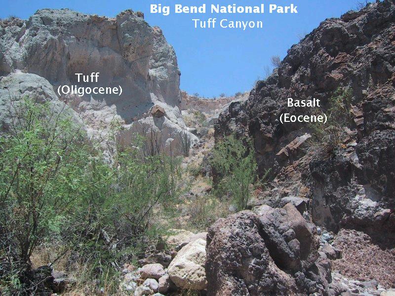
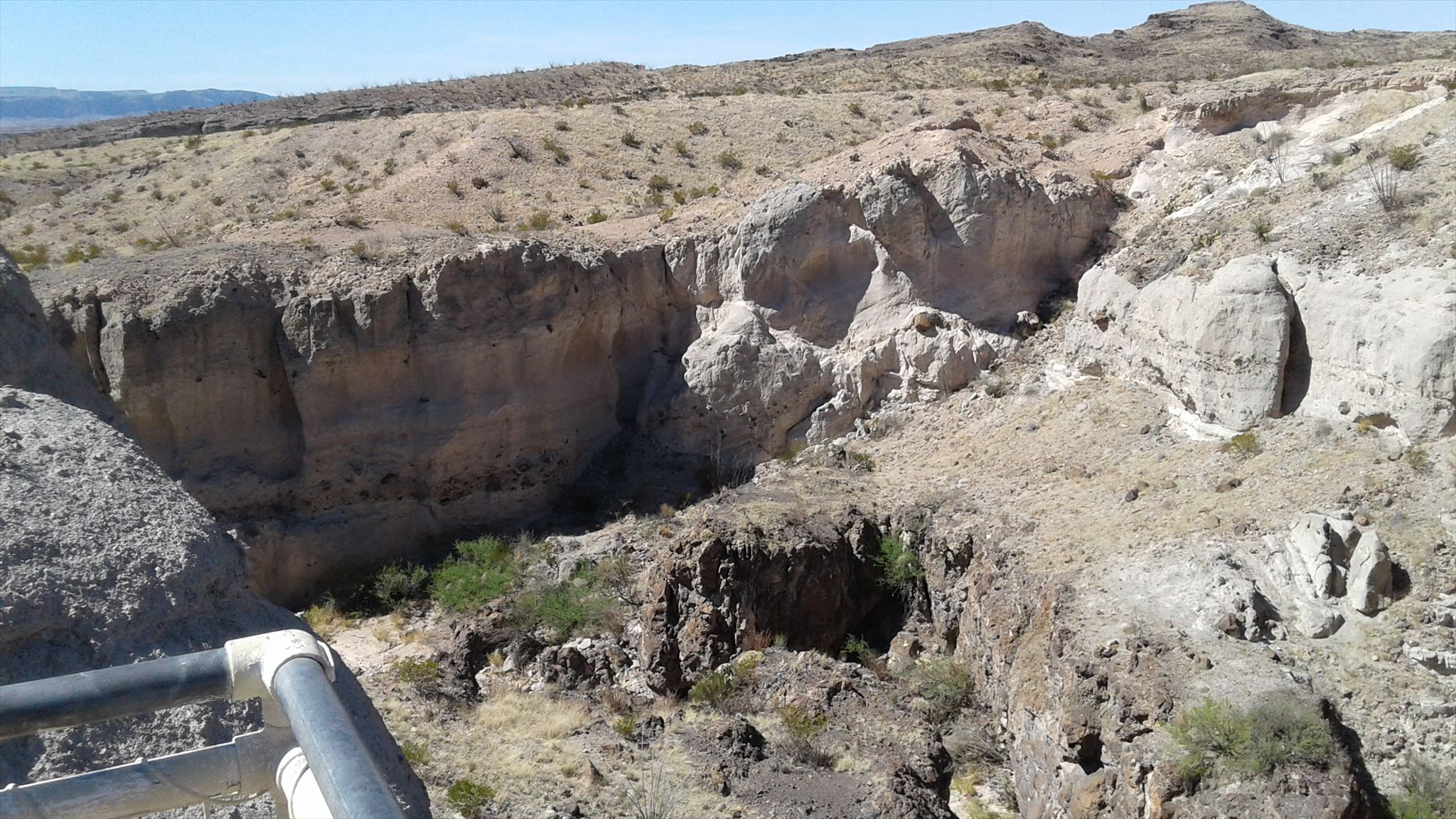
Tuff Canyon is another interesting canyon within the boundaries of Big Bend National Park (BIBE). Tuff Canyon is located about two miles north of historic Castolon on Ross Maxwell Scenic Drive, which is on the west side of the national park. There are signs and a parking area for Tuff Canyon visitors. To meet the requirements of this earthcache you will have to hike down inside the canyon. Although not required, I encourage you to check out the observation platforms overlooking the canyon, especially the east observation platform.
Warning: Do not enter the canyon if rain is falling anywhere upstream of Tuff Canyon; flash floods can move rapidly through narrow canyons like this one. Be sure to follow park guidance on other aspects of hiking in the desert as well. The link at the top of the page goes the Daily Report of conditions at BIBE.
One last reminder: Disturbing or removing rocks, plants, animals or artifacts is prohibited within National Park boundaries.
INTRODUCTION
The Big Bend area is a favorite place for many geologists because the results of so many different geological events are easily visible here. Tuff Canyon is no exception. The geological formations at Big Bend show evidence of many of the major forces that shape landscapes: volcanic eruptions, earthquakes/faults, underwater sedimentation, magma eruptions and erosion.
GEOLOGICAL BEGINNING
The foundation of what is now Tuff Canyon was formed about 34 million years ago by lava from an erupting volcano. This dark-colored lava (called Bee Mountain Basalt) formed a hard and fairly smooth surface over most of the flow. Some of this basalt lava is visible today on the eastern side of the canyon, and is easily seen from the east observation platform. The dark color comes from the high content of iron in the basalt. A closer look will reveal that there were multiple basalt lava flows. The last basalt lava was a massive unbroken flow indicating that it traveled over dry land. But underneath that one (and visible in rocks at the far east end of the canyon) is evidence that basalt lava flowed into standing water: breccia and pillow lava. Breccia is a matrix of small lava fragments. The hot lava flowed into water and was shattered by steam explosions as the water violently turned to steam after absorbing heat from the lava. Pillow lava is the result of a less violent interaction with water. The pillows are smooth, rounded masses where the outer skin cooled quickly against the water and provided enough insulation to let the inside cool off slowly. The skin is strong enough to hold the hotter lava inside but is still pliable enough to mold to the shape of underlying rocks. Pillow lavas are the most widespread volcanic features on earth because they cover enormous areas on the ocean floors.
Sometime in the 5 million years following the Bee Mountain Basalt lava event, another volcanic eruption occurred. How do we know this happened in that timeframe? Because the evidence of this eruption is also found in Horseshoe Canyon, about 1600 feet east-southeast of Tuff Canyon. In that canyon, however, it is covered by lava called Burro Mesa Rhyolite which has been dated to 29 million years old.
TUFF EVENT
This last volcanic eruption near Tuff Canyon was not as mild as the prior event because it left tuff, a type of pyroclastic material. Pyroclastic is Greek for “fiery pieces”, referring to hot material explosively ejected from a volcano. Tuff is an igneous rock, formed from ash and other debris from an explosive volcanic eruption that have been compacted and cemented together in the presence of water. Deposits of tuff are usually “lens shaped” rather than flat layers, with the thickest part being nearest the volcano or on the side of the vent where the blast was directed. Typically, tuff has a high silica content which can make it quite hard. Because tuff contains pockets of poor or weakly cemented material, tuff often weathers unevenly into pitted surfaces depending on the strength of the bonding.
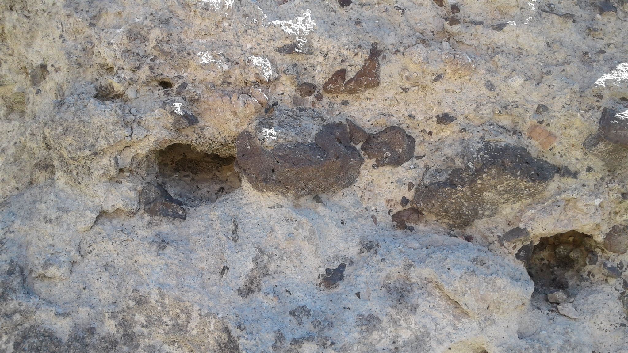
The ash in Tuff Canyon consolidated into rock, and mixed in with it are other materials of various sizes from sand-sized grains all the way to boulders. The presence of these particles of various sizes (especially the really large ones) mixed into the solidified ash indicate that the tuff was deposited fairly close to its source. The ash, being very small and light, can be carried larger distances in the air than can particles the size of sand, which can travel farther than gravel-sized particles, which can travel farther than boulders. In Tuff Canyon there are layers where these are all intermixed.
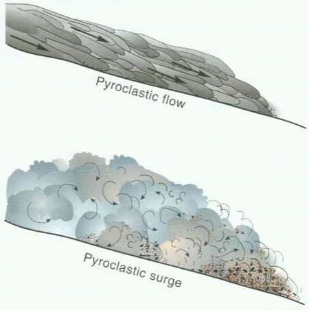
Tuff Canyon has layers from three different types of flows coming out of this volcanic event: debris flow, pyroclastic flow and pyroclastic surge. Debris flow is a moving mixture of rock particles and water, commonly having the consistency of fresh concrete. Debris flow deposits can include very large rocks and usually different sized rocks that are all mixed together (not well sorted by size). Debris flows often accompany explosive eruptions due to all the loose material on the surface of the volcano, waiting to be washed downslope. Also, because water vapor is a large part of the gas emitted by volcanic eruptions, there can be heavy rainfall concentrated near the volcanic vent. That rain condenses on ash particles and forms thick but fast-moving mud. Pyroclastic flows are hot clouds of rock particles, gas and liquid lava droplets that are relatively dense and tend to move in laminar (smooth) flow. The pyroclastic flow deposit left in Tuff Canyon is a thick layer of more uniform gray color than the coarse debris flow layer. Pyroclastic surges are also hot clouds of gas, liquid lava and rock particles but are less dense than flows and move quickly with turbulent (tumbling) flow.
CANYON FORMATION
In the millions of years after the tuff formed over the basalt lava, Blue Creek (as an agent of erosion) cut the small gorge known to us as Tuff Canyon. Blue Creek, now usually dry, starts high on the western flank of the Chisos Mountains and flows generally southwestward toward its destination at the Rio Grande. As you will witness, Tuff Canyon has a gravel bed. This gravel bed is difficult to wash away because the cobbles are large and often interlocked. Where the creek has cut through the gravel, the underlying sedimentary rocks are soft and easily eroded by running water. The smaller particles (sand and silt) are carried downstream to the Rio Grande and beyond. The igneous tuff is also worn away over time. As a result, the creek cut a narrow, steep-walled gorge that offers us a close-up view of the different pyroclastic layers that have been exposed. Toward the middle of the canyon there are side valleys that are perpendicular to the main canyon along a fault line. Where these side valleys connect, the main canyon is wider due to increased erosion and weathering along the fault. The fault is buried in the floor of the side canyon on the southwest. The rocks on the east (upstream) side of the fault are lower and more sloped than the rocks on the west side of the fault because the rocks exposed on the west side are more resistant to weathering and erosion. So the west banks of the side canyons form higher and deeper cliffs than those on the east side.
QUESTIONS
Once you have learned about the geology of Tuff Canyon and witnessed it up close for yourself, send the answers to the following questions to me through geocaching.com. Please do not post your answers in your online log, but do feel free to post photos at the canyon as long as they do not give away the answers.
1. Describe Tuff.
2. Which major geological forces that shape landscapes have left results visible at Tuff Canyon?
3. Estimate the width of the canyon at GZ.
4. How large is the visible diameter of the largest dark rock on the canyon wall near GZ?
5. At GZ is the layer roughly knee to head high composed of particles larger or smaller than the layers above and below it? What type of layer is this?
Sources:
Down to Earth at Tuff Canyon, Big Bend National Park, Texas: Daniel S. Barker, Texas Bureau of Economic Geology, 2000.
The Rock Book, Carroll Lane Fenton, Mildred Adams Fenton, Dover Publications, Inc.: 2003, page 128. ISBN#0-486-42267-4, 31 East 2nd Street, Mineola, NY 11501
Where the Tuff Gets Going: Tuff Canyon; a Virtual Geological Field Trip; Francis Redfern; prism-redfern.org/bbvirtualtrip/bbvft.html.