One of the "Life's a Beach" series.
If you would like to add more caches to this series, please feel free to do so!
Please contact heartradio through his profile first so that he can keep track of numbers and avoid duplications. Caches can be any type except traditionals.
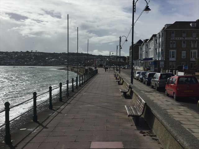
Penzance is the main town of Mounts Bay, an area in the SW part of the county of Cornwall, and is the SW end of the line for the railway. Penzance beach consists mainly of rock and shingle and runs the length of the promenade – from the Lido, (Jubilee Bathing Pool), to Wherrytown.
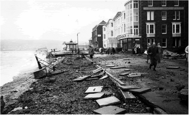
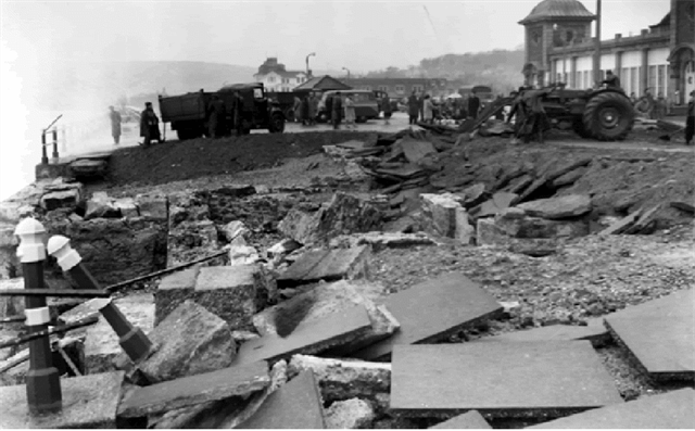
In March 1962 Penzance was subject to one of the worst floods in living memory. “The Great Storm” first hit America killing 40 people and then moved on to the western tip of Cornwall, with Penzance and Newlyn bearing the brunt of the damage. Roads were closed, boats in the harbour were torn from their moorings, railway tracks were washed away and over 300 people were rendered homeless. Large sections of the western end of the promenade were ripped out and a row of worker's cottages in Wherrytown were wiped out by the sea. The army were drafted in to help with the clean-up and it took eight months to repair the sea defences alone. The design of them was changed to incorporate a curved wall in order for flood waters to be directed back into the sea.
The rocks referred to in this earthcache are metamorphic, igneous and sedimentary. Metamorphic rock is created when rock is subjected to very high heat and pressure and transforms into a different type of rock, (slate and serpentinites), igneous rock is formed when magma cools and solidifies, (granite and gabbro), and sedimentary rock is the product of sediments that have settled at the bottom of a lake, sea or ocean and have been compressed over millions of years, (sandstone and mudstone).
The two peninsulas of Mounts Bay, “The Lizard” and “Lands End,” differ geologically. The Lizard Peninsula is composed of mostly serpentinites and Gabbro, whilst the Lands End Peninsula consists mainly of granite. The rest of the coast consists mainly of Devonian sandstone, slate and mudstones. Mounts Bay itself is mostly Devonian slate.
Peninsulas, (Headlands), are formed when the sea attacks a section of coast. The areas of soft rock, such as sandstone, erode more quickly than those of a harder, more resistant rock, such as granite. This coastal erosion leaves a section of land jutting out into the sea, a peninsula. The area where the soft rock has been eroded away next to the headland becomes a bay.
The physical properties of a rock, such as its resistance to erosion is known as Lithology. If the different rock types run parallel to the coastline, concordant, the sea will only be able to break through more resistant rocks in a few places. If the different rock types run at right angles to the coastline, discordant, less resistant rocks are exposed and will erode more quickly and a clear pattern of headlands and bays will emerge.
The rate of coastal erosion varies due to factors such as the lithology of the coastline and the strength of the waves. The coast of Cornwall experiences one of the highest energy wave climates in the UK due to its extreme westerly mainland location and its predominantly south-west, west and north-westerly facing shorelines.
The types of coastal erosion that can occur are:-
Hydraulic Action: When a wave impacts with a cliff face, air is forced into cracks under high pressure, widening them. Over long periods of time, the growing cracks destabilise the cliff and fragments of rock break off.
Corrasion/Abrasion: The repeated action of waves breaking on a cliff is enough to remove material from it over time. If sand & shingle are present in the water, it will act like sandpaper and erosion will take place faster.
Attrition: Beach material like pebbles are knocked together in water reducing their size and increasing their roundness & smoothness.
Corrosion: Carbon dioxide in the atmosphere is dissolved into water turning it into a weak carbonic acid. Several rocks are vulnerable to this acidic water and will dissolve into it.
Logging requirements:-
Message me via the message centre the answers to the following questions BEFORE logging as found. Please go ahead and log as found after sending the answers and I will contact you to confirm as soon as I can, which may be several days if I am away on holiday. If someone else is sending the answers on your behalf please state this in your log. Any logs without accompanying answers may be deleted without further notice.
Take a stroll along the length of the prom.
1. Do you think the coastline is concordant or discordant? Give your reasons for this conclusion.
2. Explain the type of coastal erosion that Penzance beach geology is susceptable to and why.
3. Identify the man-made flood defenses that you can see in place.
4. Which part of Penzance promenade is most at risk of further coastal erosion and resultant flooding? Give your reasons for this conclusion, including what you can see at that point of the prom which indicates this.
5. Photo's as part of your log are always appreciated, but are not compulsory. Please don't give away the answers to No 4 in your photos.
Information about the flood is from the related website on the cache page and "The Cornishman" newspaper.
