Lake Iroquois Hamilton/Burlington Isthmus
Lake Iroquois Hamilton/Burlington Isthmus extends from Dundurn Castle in the South to RBG’s Rock Garden in the North, with Cootes Paradise on one side and Burlington Bay on the other. This formation is the shoreline and beach bar to the prehistoric Lake Iroquois, the precursor to Lake Ontario, formed at the end of the last ice age.
Bay mouth bars form when river systems flow more strongly around the edges of the bay than they do down the middle. Of course the exact composition of each bar depends on the soil type, current velocities and volume of the flow. These bars usually consist of accumulated gravel and sand carried by the current of longshore drift and deposited at a less turbulent part of the current. Thus, they most commonly occur across artificial bay and river entrances due to the loss of kinetic energy and complementary wave action.
Isthmus? Peninsula? What’s the difference?
Isthmus and peninsula are two geography terms that refer to completely different landforms. An isthmus is a narrow strip of land that joins two larger bodies of land, a “Land Bridge” with water on two sides. It is often the most direct land route between two large areas. Two of the most well known isthmuses are the Isthmus of Panama, connecting Central and South America, and the Isthmus of Suez, joining Asia and Africa. The Niagara Peninsula, is actually an isthmus, separating Lake Ontario from Lake Erie.
In contrast, a peninsula is a piece of land that is surrounded on three sides by water, also forming a narrow strip, instead of joining two larger landforms, it is attached at one end, and juts out into a body of water. The state of Florida is a peninsula. It is part of North America, but surrounded on three sides by water: the Atlantic Ocean and the Gulf of Mexico.
The Human Connection
As far as human history goes, Isthmuses have always been strategic locations. They are natural sites for ports and canals linking land and aquatic trade routes. Isthmuses are also key sites for communications, cultural exchange, as well as military outposts.
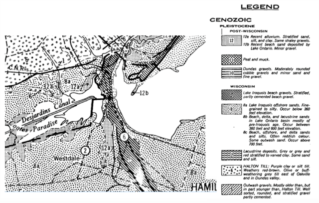
Above is a map of the area’s local geology. The Lake Iroquois Hamilton/Burlington Isthmus is marked with dark diagonal lines. The “6” in the circle represents Highway 6, before the construction of the 403
To claim this EarthCache, please submit the answers to the following questions to the CO at the top of this cache page. Do your very best with the answers, and remember hat the goal of this EarthCache is to teach you a bit more about the local geology, and hopefully you learn something new.
Questions:
1) What are the two bodies of water separated by the Lake Iroquois Hamilton/Burlington Isthmus?
2) Lake Iroquois Hamilton/Burlington Isthmus was formed by the wave actions and lake currents in Ancient Lake Iroquois. With this being the case, what type of material would one expect to find in the Burlington Heights Isthmus. Information from the cache page will be helpful.
3) Find the difference between the average surface Elevation of Lake Ontario (74 metres), and that of the Ancient Lake Iroquois shore, by taking an elevation reading at GZ, the top of the Isthmus.
4) An Isthmus can be an important feature for transportation. Without this natural feature, the drive from Dundurn Castle in the South to RBG’s Rock Garden in the North, would be quite a bit longer. Use Google Maps Driving Directions (or something similar) to determine just how much longer the drive would be, time and kilometers.
5) Lake Iroquois Hamilton/Burlington Isthmus was also an important feature during the war of 1812. Speculate as to why you believe this might be a strategic position in defending the area.
6) At the posted coordinates, there is further information about the soils in the area. What two materials does it say the ridge is made up of, and how many years ago was it formed.
7) Standing at the Lookout Waypoint overlooking Burlington Bay, describe where you see a Peninsula in the distance. For the purpose of easy communication, using the name(s) of a cache(s) at that location is an acceptable way to describe the location of the peninsula)
8) Optional: Post a photo looking out from the Lake Iroquois Hamilton/Burlington Isthmus