This site is an SSSI. Please do not damage the rocks in any way.
You will need to visit at low tide In order to walk round the headland (Spittal weather and tides)
About 330 million years ago this region was in equatorial latitudes. Sea level fluctuated so sometimes the area was beneath the sea and sometimes large rivers were flowing over the surface, maybe into an estuary. You can imagine that rocks that formed in deep and then shallow seas are different from those which form on the banks and in a large river.
The whole series of different rocks indicating these different environments can be seen here. There were large river channels with mobile sand bars and alluvial plains upon which the Carboniferous forests grew. The sea then came in over the area and became deep enough for corals to flourish. This must have happened quite quickly as the limestone with corals can be seen directly on top of the coal. When the sea deepened further, mud was deposited but when the sea retreated, the area was once more dominated by rivers depositing a variety of sand, silt and mud according to climatic conditions. The cycle then starts again with the alluvial plains upon which the forests grew. These conditions cycled lots of times (cyclothem) as a result of glacials (sea level low) and interglacials (sea level high) and the enormous delta (like the Mississippi) changing shape.
| The environments and resulting rock types are shown below:- |
|
| tropical forest |
coal |
| soils |
fossil soil (seatearth or fireclay) |
| rivers - muds, sands, silts |
mudstone, sandstone, siltstone |
| shallow sea |
limestone |
| deep sea |
shales (compressed mudstones) |
What to do:
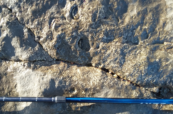
1. N 55°45.180 W 001°59.062 Here you can see the Dun Limestone.
This limestone contains fossils as seen in the photo below. The white bits are parts of corals and you can also see bits of shells, probably from a variety of shellfish called brachiopods. The small round 'polo mints' are parts of the 'stem' of animals related to starfish called sea lilies or crinoids.
Describe what it would be like to go back to this area when the limestone was forming.
(a) Where are you and do you need special breathing equipment?
(b) What animals can you see around you?.
2. N 55°45.126 W 001°59.076 In this area you are looking at beautiful 'stripy' sandstones, siltstones and mudstones.
(a) Describe what it would be like to go back to this area when these rocks were forming. Could you stand up?
(b) Name a place today that might be similar.
3. At N 55°45.024 W 001°58.943 the orange stain across the beach below the hill known as Toppye Knowe is from water draining from the old mine level. The tunnel was cut to drain water from Scremerston Main Seam and the Cooper Eye Seam of Scremerston Colliery deep below Huds Head.
What do you think has coloured the rocks orange?
4. N 55°45.016 W 001°58.917 Fossil bark from a tree. If this boulder is no longer here, there are lots of other examples of plant fossils around here.
Describe what it would be like to go back to this area when there were Carboniferous tropical forest trees growing. Were there any flowers or insects? (A search engine like Google might help)
5. N 55°45.003 W 001°58.883 Hud's Head. Please do not climb the cliff.
You will be able to see the Dun Limestone as the hard band in the middle sloping down to the beach. You can see a band of coral at the base of it and beneath that is a thin coal seam. The fossil soil (seatearth or fireclay) is below that.
Estimate the thickness of the coal seam.
6. N 55°45.003 W 001°58.878 Iron nodules can be seen here in the shale. They formed as iron accumulated in the mudstone, possibly around a tiny fragment of organic material.
What is their average long dimension?
Please email your answers to me, JurassicEdie or through the Message Centre
Either return to the car park the way you came or continue round the headland to N 55°44.929 W 001°58.766 Hud's Head Quarry where you could try the EarthCache Hud's Head Quarry Quest.