밀양 남명리의 얼음골은 천황산 동북쪽 산줄기 재약산의 북쪽 계곡에 위치하고 있다. 얼음골 계곡은 동·서·북 3면이 절벽으로 되어 있으며 북쪽은 돌밭으로 되어 있다. 약 8천만년전(중생대 백악기말) 이곳은 화산지역이었으며, 낮은 지대에서는 공룡들이 살았었다. 이때의 화산활동으로 이곳의 산과 계곡을 이루고 있는 화산암(석영안산암)과 응회암이 만들어졌다. 오랜 세월이 지나 빙하기에 이곳 암석들이 얼고 녹는 과정을 반복하며 무너져 내리면서 얼음골 계곡 경사면에 쌓이게 되었다. 이 돌무더기들을 너덜겅 또는 너덜지대, 돌서령, 애추(Talus)라 부른다. 대체로 6월 중순부터 이곳 Talus 바위틈에 얼음이 생기기 시작해서 7월말∼8월초에 가장 많은 얼음이 생기며, 겨울에는 얼음이 생겼던 바위틈에서 따뜻한 공기가 나와 계곡물도 얼지 않는다. 이와 같은 현상은 암석속에 틈이 많이 생겨서 일어난다고 하는데, 밀양의 신비로 불려진다.
여름철 Talus 돌밭 위쪽 바위틈새로 부터 유입된 따뜻하고 건조한 공기는 돌더미 내부에서 냉각되어 Talus 돌밭 아래쪽 바위 틈새에서는 차고 습한 공기로 흘러나온다. 한편 이 차고 습한 공기가 따뜻하고 건조한 외부 공기와 섞이는 바위틈새 바닥 부근은 물의 갑작스러운 증발에 의해 더욱 냉각되므로 얼음이 형성된다.
* 입장료 : 어른 1,000원, 중고생 700원, 초등학생 400원
[로그하는 방법]
- 여름에 얼음이 어는 현상은 Talus(암석 파편)에 틈이 많아서 일어난다(진실/오류)
- 얼음골은 재약산의 북쪽 사면에 위치하고 있습니다. 만약에 이러한 Talus가 남쪽 사면에 위치한다면 1번 질문에서 설명한 현상이 일어날까요? 그 원인은 무엇이라고 생각하나요?
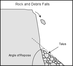
- Angle of Repose는 얼마나 되나요? 각도로 답변해 주세요.
- Talus 경사면을 만들고 있는 바위들의 평균 크기는 직경이 얼마인가? 아주 큰 것과 아주 작은 것은 제외하고...
- Talus 경사면에서 보이는 돌의 종류는 무엇인가요? 이름을 잘 모르면 특징을 묘사하세요.
- 캐시존에서 보이는 Talus를 배경으로 당신 또는 당신의 GPS를 찍은 사진을 로그에 올려주세요. (선택사항이지만 사진을 올려주시기를 부탁드립니다.)
- 답을 제 Profile에 있는 메시지창을 이용해 제게 보내주세요. 이제 로그하셔도 됩니다. 답에 문제가 있을 경우 제가 메시지를 드리겠습니다.
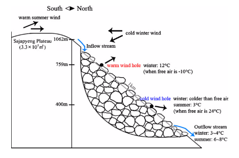
The geology of the area consists of Late Cretaceous volcanic rock (dacitic welded ash flow tuff and andesite) and biotite granite. The rocks around the cache zone was formed with the volcanic activities about 80 million years ago. The rocks have gone through the glacial epoch. The rocks on the northern slope of the mountain were broken into pieces and fallen down a cliff as a result of erosion. Surface of Ice-valley have much air tube and space constructed by accumulation of big and hard rocks crumbled from steep cliff. Such slope with accumulated debris is called talus especially andecite rock talus.
This ice valley, one of Miryang’s tourist destinations, has gained immense popularity due to the phenomena observed: Naturally, water is frozen even at the peak of summer and the ice melts out in autumn. In winter, hot steam rises from the valley and the water does not freeze. These phenomena are attributed to local airflow patterns. Cold underground air and cold water flowing beneath the talus in the valley are primarily responsible for the subzero temperature environment, leading to the formation of ice in summer. In contrast, both air and water coming out from the talus in the valley are warm, and so the ice is not formed in winter.
* Admission fee : Adult 1,000won, Middle & high school student 700won, Primary school student 400won
[How to log]
- The formation of ice in summer occurred due to the gap between the rocks consisting the talus.(True/False)
- Ice valley is located on the northern slope of Jaeyaksan Mountain. If this kind of valley is located on the southern slope of the mountain, will there be the same phenomonon explained in Question 1? What do you think is the reason?
- Estimate the angle of repose for this slope!
- What is the average size of the rocks that make up this talus slope? Exclude exceptionally large and small pieces when you check the size!
- What is the type of rock you see in the talus slope? If you do not know its name, describe its characteristics!
- Upload the photo of you or your GPS with Talus at the cache zone in the background! (The task is optional but I would highly appreciate if you would do so.)
- Please send the answers to me by message on my profile! You may log as 'Found'. If the answer is not correct, I will contact you.
(Reference: Milyang City, Hi-Ryong Byun&Hiroshi L. Tanaka&Pom-yong Choi&Do-Woo Kim)
| I have earned GSA's highest level: |
 |