The rocks which you see in Rouken Glen were mostly formed during the Carboniferous geological period about 325 million years ago. The name means ‘coal bearing’ . These rocks are common in Scotland’s Central Belt. At this time Scotland was close to the equator with a humid tropical climate. This area was part of a huge coastal plain on the edge of a shallow sea. The landscape was changeable. Sometimes the sea flooded the land and the shallow tropical seas allowed corals to grow and marine plants and animals to thrive. Sometimes there were large river deltas and muddy swamps.
The thick sandstones represent river channels. The thin-bedded sandstones were formed in wet swamps, or in the shallow tidal seas. Coal represent forests growing in drier swamps and mudstone represents quiet water; either swamps or offshore. Limestones represent deeper marine conditions. The Rouken Glen gorge is one of the best remaining places where these rocks can be seen. It is also a unique area that contains one of the most important geological sites in Scotland. For this reason, the 'Orchard Beds' are designated as a Site of Special Scientific Interest (SSSI).
Sandstone forms where sand is laid down and buried. Usually, this happens offshore from river deltas. When sand is deeply buried, the pressure of burial and slightly higher temperatures allow minerals to dissolve or deform and become mobile. The grains become more tightly knit together, and the sediments are squeezed into a smaller volume. Cementing material moves into the sediment, carried there by fluids charged with dissolved minerals.
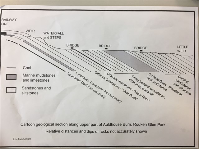
photo courtesy of John Faithful (Glasgow Geological Society)
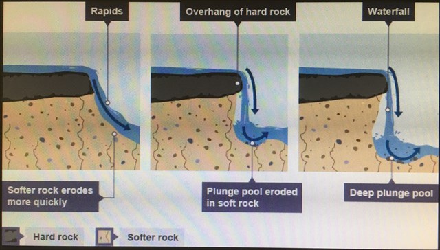
Stage 1- The waterfall at the top of the gorge is a spectacular sight, especially after heavy rain. It’s height was raised substantially to create a weir in the 18th century to give a much larger supply of water to the mills downstream. The cascading water has made dramatic geological changes over thousands of years. The rapids formed here because the Auldhouse Burn (a Scottish word for stream) has been wearing away for millennia at tilted layers of different rocks which vary in hardness. The sandstone at the waterfall is approximately 15m thick.
The steps at the waterfall are mostly carved directly from the massive sandstone. At the bottom of the steps, you can see the upper part of the Giffnock Sandstone on the far side of the burn. These upper parts are finely layered which made it useless for building. This fine layering indicates a change in the environment – the flow in the river was reduced and these layered rocks were deposited in quieter swampy waters which were sometimes briefly flooded by the sea.
Question 1. The water splits around a large rock just as it emerges from under the bridge at the top of the falls. Why do you think this rock hasn’t been eroded away?
Stage 2 - On the opposite banking you can see tilted, thin layers or beds of rock in the river. These are layers of sand, silt, mud and even coal. These were deposited in shallow swampy areas, which sometimes dried out and were sometimes crossed by small rivers. As you walk downstream you are walking over younger and younger rock layers.
Question 2. What is your estimate of the thickness of the thickest layer?
Stage 3 - Just before the second bridge a little side stream comes in. This marks the position of a thin layer of Limestone which formed in open sea water and indicating a major change in conditions. For about 150m downstream from here lie a very important series of rock layers, called the 'Orchard Beds' . They are exposed in and around the burn. Rock beds are small divisions identified in sedimentary rock layers. Each bed demonstrates a distinct set of environmental conditions present at the time the sediments were deposited. These are called Orchard Beds because they were first found in the Orchard Farm area of Thornliebank, where quarries were worked in the 19th century. The rock layers contain many interesting marine fossils called ‘Crinoids’. These were formed during the Lower Carboniferous age, when bodies of small dead creatures were quickly covered by underwater sediments like sand, silt and mud. As the layers of sediment built up they compacted into rocks surrounding the hard remains of the original creatures. They provide another indication that the area was once flooded by the sea. PLEASE BE CAREFUL, THE ROCKS ARE SLIPPY .
Question 3. Look very closely (they can be difficult to spot, you may need to get into the water, do not put yourself in danger (skip question if necessary)), can you find any Crinoids? If so, describe what you can see, size, shape, have a guess at what type of creature you think they were?
PLEASE DO NOT DAMAGE ANY THAT YOU FIND. If you don’t find any, there are some examples in the Pavilion Visitors Centre if you are interested in seeing some.
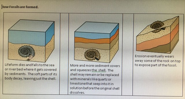
Note. Diagram shows sketch of an Ammonite not a Crinoid.
Stage 4 - Downstream a little from the Orchard Beds between the second and third bridges, look up to the top of the gorge. On the opposite side of the burn, a coarsening upward sequence is nicely exposed, with thinly interbedded siltstones at the edge of the burn, passing up into thinly bedded sandstones at the base of the cliff, under the overhang, and up into a massive sandstone forming the overhang itself. This section represents a transition from fully marine, offshore sedimentation (muds and limestones) to terrestrial floodplain sediments, and finally the sandstone. These sandier rocks were formed as rivers brought increasing amounts of sand into the sea.
Question 4. Look at the different layers, thick and thin. Describe the visual difference and what do you think caused each? (the text above should help)
Please attach a photo to your log of you, your dog, gps, thumb or something personal to prove you were here. Please do not show any spoilers in your photo.
June 2019 the logging tasks for EC were updated. COs can now insist on a photo as proof of visit.
Further information about the geology of the park can be found in the Pavilion Visitor Centre.
Special thanks to Margaret Greene and the Geological Society of Glasgow for the help in creating this EarthCache.
PLEASE SEND YOUR ANSWERS TO THE QUESTIONS ABOVE BY EMAIL OR MESSAGE AT THE SAME TIME AS YOU LOG A FIND (IF YOU HAVE INTERNET TO LOG YOU HAVE INTERNET TO EMAIL). ANY LOGS ENTERED WITHOUT AN EMAIL BEING RECEIVED WILL BE DELETED WITHOUT NOTIFICATION.
| We have earned GSA's highest level: |
 |