Introducción/ Introduction
[ES] El Morro Solar es uno de los lugares más estudiados por la geología peruana en lo que respecta a Lima, según estudios hechos por investigadores se puede decir que el Morro Solar es un promontorio de 281 metros de altura y que ocupa un área de 7.48 km2.
[EN] "Morro Solar" is one of the most studied places by the Peruvian geology in Lima, according to studies made by researchers it can be said that the Morro Solar is a hill of 281 meters of height and that occupies an area of 7.48 km2.
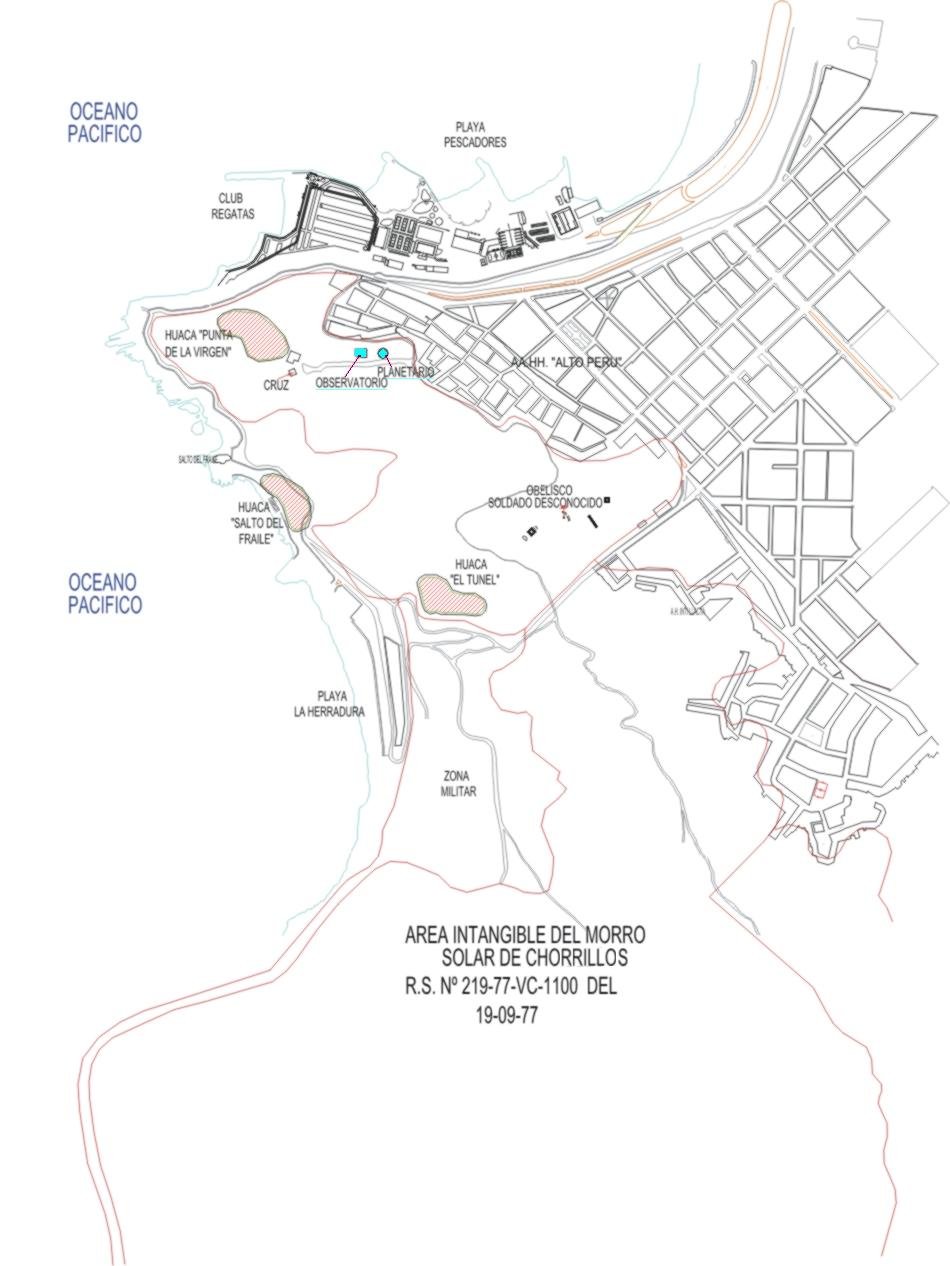
Localización del Morro Solar / Location of "Morro Solar":
[ES] El Morro Solar se encuentra situado en Chorrillos, al sur de la Provincia de Lima. Las coordenadas geográficas del Morro Solar son: Long. 77° 01’ 57’’.7 W. de Greenwich y Lat. 12° 11’ 07’’.9 S.
[EN] "Morro Solar" is located in Chorrillos, south of Lima. Its geographical coordinates are: Long. 77 ° 01 '57 "W. 7 W. Greenwich and Lat. 12 ° 11 '07 "9 S.
Geomorfología del Morro Solar / Geomorphology of Morro Solar:
Acantilados / Cliffs:
[ES] Los acantilados son accidentes geográficos que consisten en una pendiente o vertical abrupta. En Chorrillos se puede observar un gran acantilado, mayormente poblado y con construcciones lujosas sobre estos. Se puede ver también que en las partes con mayor pendiente no hay vegetación mientras que en las partes con menor pendiente existe vegetación.
Los acantilados suelen estar compuestos por rocas resistentes a la erosión y al desgaste por la acción atmosférica generalmente rocas sedimentarias como la limonita, arenisca, caliza, dolomita,aunque también pueden apreciarse rocas ígneas, como el basalto o el granito en estas formaciones.
[EN] Cliffs are geographic formations that consist of an abrupt slope or vertical. In Chorrillos you can see a great cliff, mostly populated and with luxurious constructions ih there. It can also be seen that in the parts with greater slope there is no vegetation while in the parts with less slope there is vegetation.
Cliffs are usually composed of rocks that are resistant to erosion due to the atmospheric action of sedimentary rocks such as limonite, sandstone, limestone and dolomite, but igneous rocks such as basalt or granite can also be seen in these formations.


Terrazas de Abrasión Marina / Marine Abrasion Terraces:
[ES] En el Morro Solar se puede observar la terraza de quebrada del Salto del Fraile de una longitud aproximada de 120 metros y que comienza a una altura aproximada de 25 m.s.n.m., siendo un barranco bastante obliterado debido a la construcción de la carretera que pasa por "La Herradura".
[EN] In "Morro Solar" you can see the ravine terrace of "Salto del Fraile" of a length of approximately 120 meters and that starts at an approximate height of 25 msnm, being a ravine quite obliterated due to the construction of the road that passes through "La Herradura" beach.

Playa / Beach:
[ES] Lo que ahora se observa como acantilados algún día fueron el fondo marino. Y si se prolongara idealmente los acantilados tratando de hacerlos encajar con las terrazas esto se haría mas evidente.
Los Estratos del Morro, al igual que los de las islas San Lorenzo y el Frontón que se encuentran a 16.5 Km de distancia, forman una cadena alternante de pizarra y areniscas, en todos estas estructuras de común origen se presentan Siles y Diques volcánicos así como también diversidad fallas de tensión.
Charles Darwin, durante su viaje alrededor del mundo, exploró la isla San Lorenzo en 1835, y a su vez Antonio Raimondi recolectó en ella fósiles que fueron posteriormente estudiados por Gabb.
Las capas estratigráficas del Morro y de las Islas son del límite Jurásico – Cretácico y específicamente en las del Morro aparecen en orden de inferior o superior las siguientes estructuras:
[EN] What we can see now as cliffs someday were the seabed. And if the cliffs were ideally will extended to try to fit them into the terraces, this would become more evident.
The strata of "Morro Solar", as well as those of the "San Lorenzo" and "Fronton" Islands that are to 16.5 km of distance, form an alternating chain of slate and sandstone, in all these structures of common origin Siles and volcanic Dykes are present as well as also diversity of strain faults.
Charles Darwin, during his trip around the world, explored the "San Lorenzo" island in 1835, and in turn Antonio Raimondi collected fossils that were later studied by Gabb.
The stratigraphic layers of "El Morro" and Islands are of the Jurassic - Cretaceous boundary and specifically in those of "El Morro" they appear in order of inferior or superior the following structures:
Formación Salto del Fraile / "Salto del Fraile" Formation
[ES] En las faldas del cerro la Virgen afloran 80 metros de cuarcitas compactas que van del color blanco grisáceo a gris parduzco siendo de estratificación gruesa en la parte baja, fina en la media y estratos de 0.5 – 1.5 m. En lo alto de la base tiene Glossofungites habichi.
[EN] In the skirts of "La Virgen" hill emerge 80 meters of compact quartzite that go from grayish white to brownish gray, being of thick stratification in the lower part, thin in the middle and strata of 0.5 - 1.5 m. At the top of the base is Glossofungites habichi.

Recursos Geológicos / Geological Resources
[ES] La base de la columna estratigráfica expuesta en las islas la constituye cuarcitas gris verdosas a gris parduzca en la parte central del lado NE de la isla San Lorenzo.
Los estratos tienen espesores de 0.5 - 1m. El espesor máximo expuesto es de 45m. No se han hallado fósiles El limite superior lo constituye el primer lecho de lutitas.
[EN] The basis of the stratigraphic column exposed in the islands is constituted by greenish-gray to brownish gray quartzites in the central part of the NE side of the " San Lorenzo" island.
The strata have thicknesses of 0.5 - 1m. The exposed maximum thickness is 45m. No fossils have been found the upper limit is the first bed of shales.
Formación la Herradura / "La Herradura" Geological formation
[ES] En el Morro esta formación ha sido dividida en dos miembros: un miembro inferior, la Virgen, con lutitas brunas y negras de estratificación muy fina, además tiene nódulos calcáreos y fragmentos de ammonites.
Las lutitas del miembro La Virgen afloran en la falda NW del Morro Solar, conocido como "Soldado Caido"; hacia arriba pasan gradualmente a areniscas finamente estratificadas de grano muy pequeño que constituyen los estratos inferiores de la formación La Herradura suprayacente.
El otro miembro es la Herradura, que está compuesto en la parte baja de areniscas blancas y grises con fósiles como Lissonia riveroi y otros ammonites no identificables, la parte media se compone de lutitas negras finamente estratificadas en la zona de La Herradura, y la parte alta consiste de calizas negras compactas que forman un banco potente, contiene ammonites y lamelibranquios. Su espesor es de 5 m en La Herradura.
[EN] In "El Morro" this formation has been divided into two limbs: a lower limb, "La Virgen", with shales brunas and black of very fine stratification, also has calcareous nodules and fragments of ammonites.
The shales of the member "La Virgen appear" in the skirt NW of "El Morro Solar", known like "El Soldado Caido"; Upwards gradually pass to finely stratified sandstones of very small grain which constitute the lower strata of the overlying "La Herradura" formation.
The other member is "La Herradura", which is composed in the lower part of white and gray sandstones with fossils such as Lissonia riveroi and other unidentifiable ammonites. The middle part consists of finely stratified black shales in the area of "La Herradura", and high part consists of compact black limestones forming a powerful bank, containing ammonites and lamelibranchs. Its thickness is 5 m in "La Herradura".
Fuente de información / Information source
[ES] Para finalizar la visita se pide al visitante responder las siguientes preguntas:
1. En el Morro Solar se presentan principalmente tres tipos de rocas, nombrar cuales son.
2. ¿De que color son los sedimentos oxidados en la base del Morro?
3. En la formación “El Salto del Fraile” se puede ver estratos rocosos, ¿Qué tipo de estratificación presenta?
[EN] Finally, the visitor is asked to answer the following questions:
1. In "Morro Solar" there are mainly three types of rocks. Name them.
2. ¿What color are the oxidized sediments at the base of "El Morro"?
3. In the formation "El Salto del Fraile" you can see rocky strata, ¿what type of stratification does it have?