Die Malediven sind eine Kette (der Name „Malediven“ bedeutet „Inselkette“, vgl. Mala) von 19 Inselgruppen im Indischen Ozean südwestlich von Indien und Sri Lanka. Sie erstrecken sich über 871 Kilometer in Nord-Süd-Richtung bis kurz südlich des Äquators. Die Inseln sind verteilt auf 26 Atolle Korallenriffen und liegen wie die Lakkadiven, auf dem maledivischen Rücken.
Die meisten Regionen Deutschlands, sowie Österreich und die Schweiz liegen weit entfernt vom Meer und haben keine modernen Riffe. In der geologischen Entwicklung dieser Länder spielten aber Riffe in mehreren Epochen eine wesentliche Rolle; diese Riffe können auch in geologischen Aufschlüssen demonstriert werden.
Darwins Theorie der Atollentstehung:
Schon 1842 schlug Charles Darwin eine Theorie für die Entstehung der Atolle vor, die eine Erklärung der Riffbildung bietet und heute noch akzeptiert wird. Die Theorie kann am besten anhand tropischer Inseln verstanden werden. Eine vulkanische Insel der Tropen bietet die flache untermeerische Basis, auf der sich Korallen ansiedeln und Riffe bilden können. Möglicherweise wuchs um diese Insel ein Saumriff, das an einigen Stellen nur durch einen schmalen Streifen Wassers vom Land getrennt war.
Wenn die Insel durch Erdkrustenbewegungen etwas im Meer absinkt, bildet sich eine Lagune und die Rifforganismen formen ein Barriereriff. Sollte das langsame Absinken der Insel weiter anhalten und eine bestimmte Geschwindigkeit nicht überschreiten, ist das Korallenwachstum in der Lage, dieses Absinken zu kompensieren und das Riff überlebt als Atoll.
Das Atoll tritt dabei eher als eine große Zahl kleinerer Inseln in Erscheinung, die durch Kanäle voneinander getrennt sind, und nicht als geschlossener Ring. Diese Kanäle erlauben auch einen Wasseraustausch zwischen dem offenen Meer und der Lagune.

Die Bildung der Maledivenatolle
Am Beispiel der Malediven soll dieser Vorgang noch etwas näher erläutert werden:
Die Inselwelt der Malediven (Abb. 5, 6) ist ein Teil eines mehr als 2 km dicken Flachwasserkalkpakets vor allem tertiären Alters, welches auf vulkanischem Untergrund liegt. Die erdgeschichtlichen Vorgängen lassen sich im Einzelnen wie folgt nachvollziehen (Abb. 7):
An der Kreide / Tertiär - Grenze (vor ca. 66 Millionen Jahren) und danach war Indien ein isolierter Kontinent und auf der „platten-tektonischen Reise“ nach Norden. Bedingt durch diese Plattenbewegungen gab es in NW-Indien extrem viel Vulkanismus (Dekkan-Trappe).

Abb. 5: Die Atolle der Malediven. Zwischen 6°N und 2°Nord erscheint eine doppelte Kette von Atollen (äußere und innere Plattform), die durch die Innere See getrennt wird. Riffe und Karbonatsandbarren sind schwarz gezeichnet. Nach PURDY & BERTRAM (1993), verändert.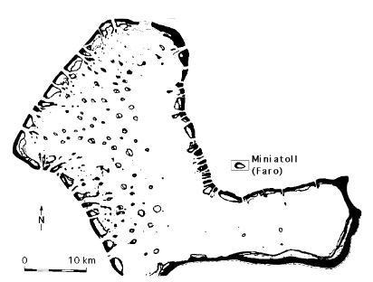
Abb. 6: Die Atolle der Malediven, wie hier das Felidu-Atoll sind überwiegend aus Miniatollen, den sogenannten Faros zusammengesetzt. Aus PURDY & BERTRAM(1993), verändert.
Im Alt-Tertiär (Eozän; 50 Millionen Jahre) lagerte sich auf einer großen Basaltaufwölbung (ähnlich wie es heute etwa zwischen Rotem Meer, Golf von Jemen und dem ostafrikanischen Grabensystem vorhanden ist) eine enorm breite, durchgehende Karbonatplattform ab.Wahrscheinlich gab es auf beiden Seiten der Plattform Barriereriffe; dahinter war alles sehr flach, aber sicher auch mit vielen Riffen besetzt. Auch diese Plattform war den tektonischen Bewegungen ausgesetzt, die in der Mitte eine Dehnung verursachten und somit einen Graben entstehen ließen (Abb. 7, A). Endpunkt dieses Teilabschnittes war die Zweiteilung der Plattform, wobei sich an beiden Teilen randständig Barriereriffe und Kalksandbarrensysteme bildeten. Durch einen starken Meeresspiegelfall innerhalb des Oligozäns fiel der gesamte Schelf vorübergehend trocken. Danach stieg der Meeresspiegel wieder an und blieb bis ins späte Jungtertiär (also während spätem Oligozän, Miozän und Teilen des Pliozäns) relativ hoch (Abb. 7, B). Allerdings wuchsen die neuen Riffe und Kalkplattformen erst einmal am Rand der älteren, da dort die günstigsten Bedingungen herrschten. Dadurch ergab sich ein breites Becken zwischen den beiden neuen randlichen Plattformen.>br> Im Laufe der Zeit verkleinerte sich das zentrale Becken wieder, da sich die hochproduktiven Kalkplattformen in diese Richtung verbreiterten, also Schutt und Riffe nach vorne bauten (progradierten); es blieb aber bis heute eine schmale innere Depression, die Innere See (‘InnerSea’).
Im ausgehenden Pliozän (vor gut 2 Millionen Jahren) begannen die eiszeitlichen Meeresspiegelschwankungen, die während des Pleistozäns anhielten (also bis vor ca. 10.000 Jahren, als das Holozän begann). Während der Kaltzeiten war der Meeresspiegel tief (das Wasser steckte im Eis der damals viel größeren Polkappen und Inlandsgletscher) und die beiden Maledivenplattformen fielen immer wieder trocken (jedoch nicht die Inner Sea). Während des Trockenfallens gab es intensive Verkarstung. Insgesamt bildeten sich mäßig konkave Strukturen auf beiden Seiten. Bei Meeresspiegelanstieg (in Warmzeiten) fingen die Riffe an den höchsten Stellen an, wieder zu wachsen.
Um mit dem rasch steigenden Meeresspiegel mitzuhalten, waren höchste Wachstumsleistungen notwendig. Auf der Strecke blieb dabei möglicher Vorbau, dazu reichte die zu geringe Produktion nicht aus. Dieses Hochwachsen ohne seitliche Verbreiterung wird als sog. Aggradation bezeichnet. Bedingt durch das Hochwachsen, einhergehend mit häufigen Meeresspiegelschwankungen bildeten sich punktförmige Riffe an den Tellerrändern aus, die letztendlich zur heutigen Morphologie führten (Abb. 7, C).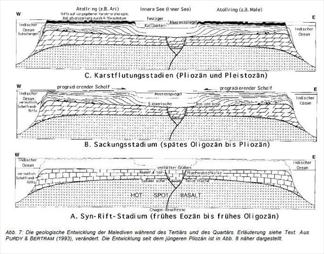
Zur Verdeutlichung und stark vereinfacht ist dieser vielphasige Prozess in Abb. 8 dargestellt:
Spätpliozänes Trockenfallen der äußeren und inneren Kalkplattform führte zu einer Süßwasserlinse und entsprechender tellerförmiger Verkarstung. An den Rändern der beiden Teller wuchsen dann bei steigendem Meeresspiegel bevorzugt Riffe, was die Anlage der beiden ehemaligen Großatollstrukturen ergab. (Abb. 8, 1 ) . Bei der nächsten, durch Meeresspiegelfall bedingten Verkarstung lösten sich die Riffe insbesondere zu großen Turmkarstblöcken auf (Abb. 8, 2). Bei der Flutung dieser Blöcke bildeten sich Riffe wiederum bevorzugt am Rande, so dass sich kleinere Atolle bildeten (Abb. 8, 3), die in ihrer Anordnung die beiden früheren Großatolle nachzeichneten. Fielen diese kleineren Atolle trocken, bildete sich wiederum Turmkarst (Abb. 8, 4), an dessen Rändern sich bei der nächsten Flutung noch kleinere Riffatolle (Miniatoll, Faro) bildeten (Abb. 8, 5). Die durch die Innere See getrennten ehemaligen Großatolle haben sich also zu zwei Ringen von kleineren Atollen (z.B. Ari, Male, Felidu-Atoll) umgebaut. Die kleineren Atolle bestehen ihrerseits wiederum aus Ringen von Miniatollen (Faros). Und so sieht es heute auf den Malediven aus (vgl. Abb.5, 6)! 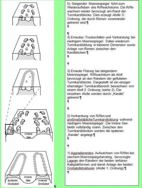
Abb. 8: Stark schematische, vereinfachte Darstellung der Atollgenese der Malediven durch quartäre Meeresspiegelschwankungen.
Wie geht es auf den Malediven weiter?
Solange der Meeresspiegel weiter ansteigt (und der Mensch tut ja sein Möglichstes dazu), werden im günstigsten Fall die Atolle weiterbestehen. Das Hochwachsen, d.h. die Aggradation hält an. Schädigt der Mensch die Riffe jedoch noch mehr, wird auch dies abreißen und die Riffe werden „ertrinken“, das heißt, das Riffwachstum wird mit dem Meeresspiegelanstieg nicht Schritt halten können und zum Erliegen kommen (dies ist bei unseren Anstrengungen wohl der wahrscheinlichste Fall).
Sollte der Meeresspiegelanstieg aufhören bzw. sich stark verlangsamen und die Riffe gesund sein, dann werden die Atollagunen zunehmend aufgefüllt werden und von den Atollen nach außen transportierter Riffschutt wird wieder die Zwischenräume zwischen den Atollen verfüllen. Darauf könnten sich Riffe in horizontaler Richtung in Richtung offener Ozean und Richtung Innere Seevorbauen, die sog. Progradation würde sich wie im Zeitraum von Oligozän und Pliozän wieder einstellen.
Von: Institut für Geologie und Paläontologie Universität Stuttgart und GEoBio-Center at LMU
Um diesen Cache loggen zu können, beantworte bitte folgende Fragen:
- schreibe mir eine Mail und erkläre mir kurz die Begriffe Tilas, Farus und Giris (sie gehören zum Riff) und nenne die Namen der 26 Atolle
- beschreibe mir in der Mail genau, welche Maßnahmen auf der Insel zum Schutz vor steigendem Meeresspiegel unternommen wurden und wenn möglich schicke mir auch optional ein Bild dazu
- schätze oder messe die maximale Höhe der Insel und teile sie mir auch in der Mail mit
- auf Fonimagoodhoo gibt es einen Wegweiser, auf dem man unter anderem die Entfernungen nach Tokyo, Ottawa, Cape Town und Paris... lesen kann, bitte schreibe mir, wo dieser Wegweiser auf der Insel zu finden ist
- bitte füge, natürlich optional, ein Foto von deiner Malediveninsel mit dir oder deinem GPS oder einem anderen persönlichen Gegenstand mit dir dem Log hinzu
- vielleicht hast du sogar ein Foto mit einem kleinen Schwarzspitzenriffhai, ich bin ein Fan dieser Tiere und würde mich über ein Foto sehr freuen, auch das ist natürlich optional
Du kannst den Cache auch ohne eine Antwort von mir loggen, wenn etwas an deinen Antworten nicht ganz stimmig ist, werde ich mich per Mail melden.
The Maldives are a chain (the name "Maldives" means "island chain", cf. Mala) of 19 island groups in the Indian Ocean south-west of India and Sri Lanka. They extend over 871 kilometers in north-south direction to just south of the equator. The islands are scattered over 26 atoll coral reefs and lie like the laccadians, on the Maldivian back.
Most regions of Germany, Austria and Switzerland are far from the sea and do not have modern reefs. In the geological development of these countries, however, reefs played an important role in several epochs; These reefs can also be demonstrated in geological surveys.
Darwin's Theory of Atoll Formation:
As early as 1842, Charles Darwin proposed a theory for the formation of atolls, which provides an explanation of the formation of reef and is still accepted today. The theory can best be understood from tropical islands. A volcanic island of the tropics offers the shallow submarine base on which corals can settle and reefs form. It is possible that the island grew on a fringed reef which was separated from the land by a small stream of water.
When the island sinks in the sea due to earth crust movements, a lagoon forms and the reef organisms form a barrier reef. Should the slow sinking of the island continue and a certain speed does not stop, Coral growth is able to compensate for this decline and the reef survives as an atoll.
The atoll appears here rather as a large number of smaller islands, separated by channels, and not as a closed ring. These canals also allow a water exchange between the open sea and the lagoon.
Fig. 4: Principles of reef and carbonate platform formation. For powerful reef and platform complexes, in particular space gain by sea level rise or ocean bottom reduction is necessary. 1a. Stable or only slightly rising sea level creates no or insufficient space. Reefs can grow (prograde) over their own debris, as more carbonates are produced than can be stored vertically. 1b. When the sea level rises rapidly, the entire carbonate productivity is required to keep pace. This results in aggrading reefs and carbonate platforms. 2. Darwin's Atoll Theory in the Light of Plate Tectonics. Active volcanoes can be found along the central oceanic backdrop or hot spots. The re-transferring plate cools slowly and decreases. Old volcanoes sink slowly and atolls can grow up.
Formation of Maldives
The Maldives' island is a part of a more than 2 km thick shallow water lime pack, mainly of tertiary age, on a volcanic surface. The history of the earth 's history can be traced as follows (Fig. 7): On the Chalk / Tertiary frontier (about 66 million years ago), India was an isolated continent and on the "plate - tectonic journey" to the north. As a result of these plate movements, there was extremely high volcanism in NW-India (Dekkan-Trappe).
Fig. 5: The atolls of the Maldives. Between 6 ° N and 2 ° North appears a double chain of atolls (outer and inner platform) separated by the interior sea. Reefs and carbonated sand bars are drawn in black. According to PURDY & BERTRAM (1993).
Fig. 6: The atolls of the Maldives, as here the Felidu Atoll, are predominantly off Miniatas, the so-called Faros. From PURDY & BERTRAM (1993).In the Alt-Tertiary (Eocene, 50 million years), a vast, continuous carbonate platform was deposited on a large basal vault (similar to that between the Red Sea, the Gulf of Yemen and the East African ditch system). Probably there were barriers on both sides of the platform; Behind it everything was very flat, but certainly also with many reefs occupied. This platform, too, was exposed to the tectonic movements, which caused an expansion in the middle and thus created a trench (Fig. 7, A). The end point of this sub-section was the division of the platform, barriers and lime sand bar systems being formed on both sides. Due to a strong sea level within the Oligocene, the entire shelf fell temporarily dry. After this, the sea level rose again and remained relatively high up to the late Jungtiary (ie during the late Oligocene, Miocene and parts of the Pliocene) (Fig. 7, B). However, the new reefs and lime platforms grew at the edge of the older ones, as the most favorable conditions prevailed there. This resulted in a wide basin between the two new peripheral platforms. In the course of time, the central basin narrowed again, as the high-production lime platforms expanded in this direction, that is, debris and reefs built up (prograded); But there still remained a narrow inner depression, the Inner Sea ('InnerSea'). In the outgoing Pliocene (more than 2 million years ago), the ice-age fluctuations in the sea level that lasted during the Pleistocene began (that is, until about 10,000 years ago when the Holocene began). During the cold periods the sea level was low (the water was in the ice of the much larger polar caps and inland glaciers) and the two Maldives platforms were always dry (but not the Inner Sea). During the dry season there was intensive karstification. Overall, moderately concave structures were formed on both sides. At sea level rise (in warm periods) the reefs started to grow again at the highest points. In order to keep up with the rapidly rising sea level, Highest growth performance. On the track there remained a possible stem, the insufficient production was not enough. This growth without lateral broadening is called the so-called aggradation. As a result of the growing up, accompanied by frequent sea level fluctuations, point-shaped reefs formed on the edges of the plates, which ultimately led to today's morphology (Figure 7, C).
Fig. 7: The geological development of the Maldives during the Tertiary and the Quaternary. Explanation see text. From PURDY & BERTRAM (1993).The development since the recent Pliocene is shown in Fig. For clarity and simplification, this multi-phase process is shown in Fig. 8: Late pliocene dry precipitation of the outer and inner lime platform resulted A fresh water lens and corresponding plate-shaped karst. At the edges of the two plates, reefs preferably grew as the sea level rose, which resulted in the installation of the two former large-scale structures. (Fig. 8, 1). At the next karstification, caused by sea level, the reefs detached themselves particularly into large blocks of tower blocks (Fig. 8, 2). During the flooding of these blocks, reefs were again formed on the margins, so that smaller atolls formed (Fig. 8, 3), which in their arrangement traced the two former Großatolle. If these smaller atolls were dry, they formed again a tower carcass (Fig. 8, 4), at the edges of which there were still smaller riffatolls (miniatoll, Faro). The former Großatolle, separated by the Innere See, have thus turned into two rings of smaller atolls (for example Ari, Male, Felidu-Atoll). The smaller atolls, on the other hand, consist of rings of miniatollen (Faros). And this is how it looks today in the Maldives (cf Fig.5, 6)!
Fig. 8: Highly schematic, simplified representation of the atollgenesis of the Maldives by quar- tary sea-level fluctuations.
How is the Maldives going on? As long as the sea level continues to rise (and man does his utmost to do so), atolls will continue to exist in the best case. The growth, i.e.. The aggradation stops. If the man damages the reefs even more, this will also tear and the reefs will "drown", ie the reef growth will not be able to keep up with the rise in sea level and come to a standstill (this is probably the most likely case in our efforts). If the sea level rise or slow down strongly and the reefs are healthy, the Atollagunen will be increasingly replenished and reef rubble will be discharged from the atolls Again fill the spaces between the atolls. Reefs in the horizontal direction towards the open ocean and towards the interior of the sea could be rebuilt. The so-called progression would reappear as in the Oligocene and Pliocene period.
From: Institute of Geology and Paleontology University of Stuttgart and GEoBio-Center at LMU
To log this cache, please answer the following questions:
- write me a mail and briefly explain the terms Tilas, Farus and Giris (they belong to the reef) and call the names of the 26 atolls
- describe to me in the mail exactly what measures were taken on the island to protect against rising sea levels and if possible send me an optional image
- guess or measure the maximum height of the island and share it with me in the mail
- on Fonimagoodhoo there is a signpost, on which you can read, among other things, the distances to Tokyo, Ottawa, Cape Town and Paris ..., please write me where this signpost can be found on the island
-Of course, please optionally add a photo of your Maldives island with you or your GPS or other personal item with you to the log
- Maybe you even have a photo with a small black tip reef shark, I'm a fan of these animals and would be happy about a photo, which of course is optional
You can also log the cache without a response from me, if something is wrong with your answers, I will report by mail.