

I came across this place a long time ago and more recently saw it was being used by an energy beverage company as part of a cliff diving tournament. Online some people suggested that there was no way the hole was natural because of how perfectly formed it appeared to be. It measures about 12m x 30m and is a perfectly formed rectangle with straight edges and is 15m deep. Also folks were curious about how it got its name 'Poll na bPéist'. I'd imagine the people who lived here long ago during stormy weather believed that there was a sea serpent thrashing away down in the depths below the surface of the hole gave it the name. The water in the hole rises and falls with the swell because it is connected to the Atlantic ocean by a wide 25m long cave.
The greyish-blue layers of limestone found here, on the Burren and elsewhere in Ireland was laid down at the end of the Lower Carboniferous (Visean) period, some 340 million years ago. Limestone is formed in a number of different ways and in different situations. It can be deposited in deep water far from land, in shallower water inshore, also be formed in tropical coastal areas as coral reefs. What was to become Ireland at this time lay south of the equator in just such a tropical shallow sea. This limestone is composed of sediments and calcium-rich remains of marine organisms that populated the warm, shallow tropical sea that lay over this area at that time.
Limestone, a sedimentary rock is defined as containing at least 50% carbonates such as calcite (calcium carbonate - CaCO3). Some limestones are almost pure carbonate, others contain varying amounts of other materials such as sand, clay (mud or shale). Calcite is formed from the fossilised shells and skeletons of dead marine organisms which fall to the seabed and build up over enormous periods of time.
While the vast bulk of the rock here is Limestone there are thinner, darker layers or bands of Shale. Shale is another common type of sedimentary rock and is described as being a ‘fine-grained, clastic sedimentary rock composed of mud that is a mix of flakes of clay minerals and tiny fragments (silt-sized particles) of other minerals, especially quartz and calcite’, it is formed under different conditions and indicates that the environment changed from time to time.
All these different layers were eventually compressed under their own weight plus that of the water above.
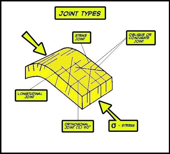
Joints are described as fractures in the rock along which there has been no movement or displacement. This is what distinguishes a joint from a fault. Faults differ from joints in that they exhibit visible or measurable lateral movement between opposing surfaces of the fracture.
A joint set is family of parallel, evenly spaced joints. A joint system consists of two or more interlocking joint sets. Joints are formed as a result of stresses and strains the bedrock would have been subjected to, events like plate tectonics or other processes such as burial and uplifting. These patterns of joints in a rock can be used to determine what kind of stress formed the joint.
These joints are described as conjugate for dihedral angles from 30° to 60°and orthogonal when the dihedral angle is closer to 90°.
The limestone exposed here and all over the island display classic orthogonal joint sets. The joints divide the bedrock into square or rectangular blocks.
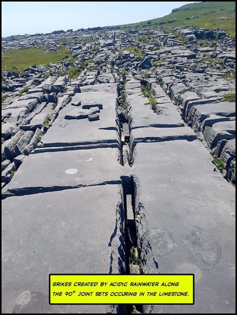
The nature of the limestone strongly influences its susceptibility to dissolution by most types of acid, which causes something called karstification. Karst is a landscape formed from the dissolution of a soluble rock such as limestone. It is named after a region on the Slovenian and Italian border.
In the atmosphere raindrops adsorb carbon dioxide forming a weak carbonic acid or a form of acid rain, This dissolves the limestone at a rate of about 0.04 mm per annum. It eats away at all exposed surfaces including the faces of the joints mentioned earlier.
This is a form of chemical weathering and it widens and deepens cracks to form Grykes, leaving blocks of limestone called Clints and this blocky rock effect is called a limestone pavement.
The shale, on the other hand, is not as susceptible to damage from the acid rain thus creating an impermeable barrier and causing the limestone to be weathered into terraces. These Shaley layers, however, are much more fragile and susceptible to being mechanically eroded, another form of erosion, due to the attritional hydraulic action of the ocean leading to undercutting and eventual collapse of the limestone above them.
A combination of these two types of erosion caused the hole to be formed this way.
Logging Requirements
Important
You will need a ruler or a measuring tape.
After making your way to the village of Gort na gCapall head to the trailhead & follow these rather lovely red hand painted signs or use the way marks to help guide you.

At the cache coordinates you will find yourself on a limestone layer a few meters above the Wormhole, in order to complete the tasks you will need to remain on this layer. I didn't choose the lower layer because that would have made it tidal dependent. Also, it would not be a good idea to attempt this in stormy weather.
What to do at GZ.
From here you will see in front of you a sort of shallow 'cave'. Go inside and make a few observations, especially the layer directly above the one you are standing on. It is a darker shaley layer (80 to 90cm thick) and is much softer than the layers above and below. It forms the deepest and lowest part of the 'cave'. you can clearly see it in some of the images provided. It looks like a deep cut in the cliff face. To find the answer to the last question go to the physical stage due West and look towards Dún Aonghasa or use the Location of the Virtual there. Have a good look along the cliffs for the answer to Q5.
QUESTIONS.

Q1. From the images above choose the most common marine Carboniferous fossil type you can see all over this island and especially as you make your way along the trail?
Q2. Look at the layers above your head, are the joints or cracks all parallel like those forming the sides of the hole below?
Q3. Is the layer you are standing on rough or smooth?

Q4. What is the thickness of the layer directly above the Shaley layer, its thickness is very uniform and is less than the softer one below it?
Q5. After going to the last Reference Point Q5 can you trace this weak layer beside you along the cliff face and all the way to the Virtual at Dún Aonghasa 750m away and can you see other weaker Shaley layers either above or below it?
Please send the answers using the message center and not by email because I may miss them there.

| I have earned GSA's highest level: |
 |