
RUTA CIRCULAR POR LA SIERRA DE ORIHUELA
Esta serie de 30 cachés tiene por objetivo realizar una ruta circular de montaña lo largo de la Sierra de Orihuela, con inicio y final en la Urbanización Montepinar, visitando la Cruz de la Muela y el Paso del Gato. Para ello seguiremos en la mayor parte del recorrido la Ruta PR-CV-59. La senda discurre por caminos y veredas delimitadas y balizadas con pintura. Espero que disfrutéis de vistas absolutamente espectaculares.
ATENCION: Se trata de un recorrido de dificultad media-alta, fisicamente exigente y que requiere tener experiencia en la montaña, así como el equipamiento adecuado. NO ES APTA para menores de 12 años o personas con vértigo o problemas respiratorios o cardiovasculares.
LA SIERRA DE ORIHUELA
La Sierra de Orihuela es una alineación montañosa situada entre el límite meridional de la provincia de Alicante y el extremo oriental de Murcia. Pertenece a la comarca del Bajo Segura, en particular a los términos municipales de Orihuela y Santomera.
La Altura Máxima es de 634 m. de altura en su punto máximo. Algunos de sus picos son la Muela, Pico de la Cruz de la Muela (564 m.), Pico del Cuervo, Pico del Águila(634 m.).
Geológicamente, se encuentra enclavada dentro del dominio bético. Junto con la sierra de Callosa forma una alineación montañosa compuesta por bloques de calizas dolomíticas del triásico, que emergen aisladas en medio de la llanura aluvial. Sus formas son abruptas y muy fragmentadas. Desde la antigüedad, estos montes han sido objeto de la actividad minera, siendo frecuentes los pozos y galerías que todavía podemos encontrar. Fundamentalmente, junto con algunas explotaciones de yesos y calizas abandonadas en la actualidad, se extraían minerales de hierro y en unos pocos lugares oro nativo.

Toda la sierra presenta numerosas oquedades, abrigos y cuevas de desarrollo variable, lo que le confiere al abrupto paisaje una cierta singularidad y belleza geomorfológica.
Hidrológicamente, toda la zona está sometida a una elevada insolación en los meses de verano. Este factor, junto con las escasas precipitaciones, dificulta la existencia de fuentes y cursos de agua permanentes. Tan sólo la fuente de San Cristóbal puede contener algo de agua tras lluvias importantes.

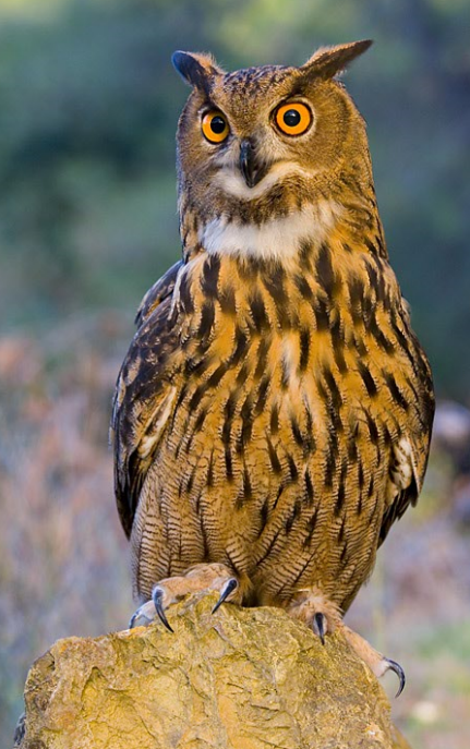
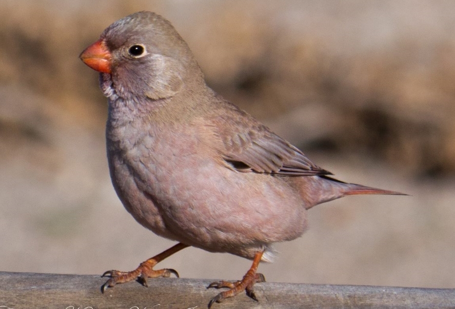
En cuanto a la fauna, las aves son el grupo mejor representado, destacando la presencia del águila perdicera (Hieraetus fasciatus) y águila real, especies gravemente amenazadas y que nidifican en la zona, búho real (Bubo bubo), el búho chico (Asio otus), cernícalo vulgar (Falco tinnunculus), gavilán (Accipiter nisus) y el halcón peregrino (Falco peregrinus). En las formaciones de cornial albergan aves raras como el camachuelo trompetero (Bucanetes githagineus) y la carraca (Coracias garrulus).
Entre los mamíferos cabe destacar la presencia del del zorro, el gato montés (Felis sylvestris), la cabra montesa y la liebre.

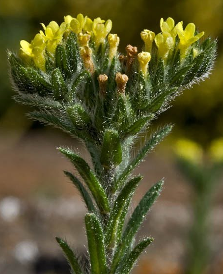
La flora es una de las variables biológicas más notables del ecosistema que alberga esta Sierra, no sólo por la gran cantidad de especies que la pueblan, entre los que destaca el Rabo de gato ceniciento (sideritis glauca) y el Cardo de roca (Centaurea saxícola) que aparecen abundantemente en las sierras de Callosa y Orihuela.
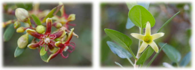
Cabe destacar también la presencia de comunidades vegetales muy peculiares, como es el caso del «cornical», o el «oroval», que en toda la Comunidad Valenciana sólo aparecen en estas sierras. Plantas que presentan curiosas adaptaciones a las condiciones de aridez locales como por ejemplo defoliar en verano en vez de en otoño. Todo ello sin menospreciar la aparición de otros cientos de especies de mayor distribución geográfica, muchas de las cuales poseen gran valor estético, aromático y medicinal.
La riqueza botánica de la sierra motivó a la administración comunitaria a declarar dos microrreservas de flora con el objeto de garantizar la conservación de estas especies y sus hábitats.
Dependiendo de la altura, orientación de las laderas, tipo de sustrato ó condiciones de insolación existen diferentes tipos de comunidades vegetales con diferentes especies que las representan, así en las zonas más altas, podemos encontrar los pastizales, espartales ó tomillares y en las zonas más bajas donde se acumula algo de suelo aparecen bosquetes de coníferas y matorral alicantino como los cornicales, espinares, genistares etc..
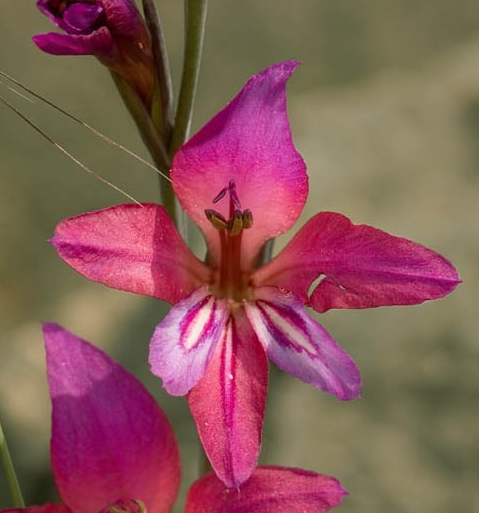
En los barrancos más umbrosos se pueden encontrar especies de helechos como algunos de los géneros Cheilantes, Asplenium ó Ceterach y en determinadas estaciones podemos disfrutar de la efímera presencia de algunas anuales tan espectaculares como las orquídeas.
LA RUTA
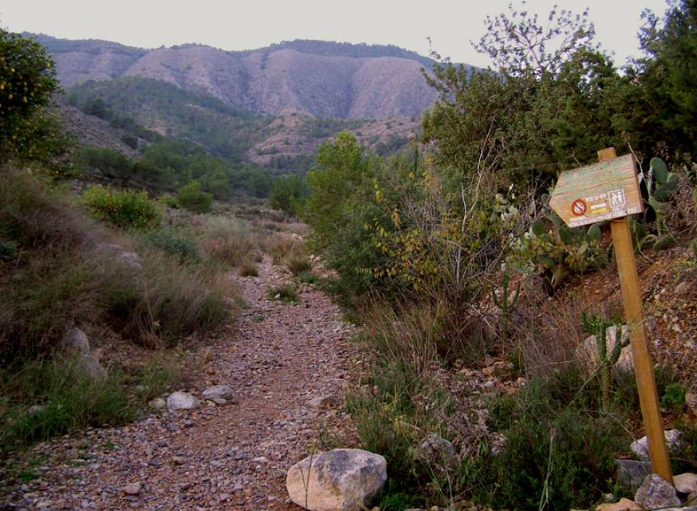
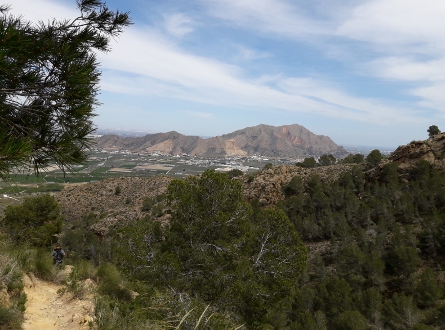
El principio de la senda de subida a la Cruz de la Muela se encuentra al final de la Urbanización Montepinar. Y está marcada por una señal. Se empieza por un camino de tierra, junto a unos limoneros. Luego se llega a una senda en buenas condiciones y fácil de seguir, ya que es muy utilizada por la gente de Orihuela y sus pedanías.
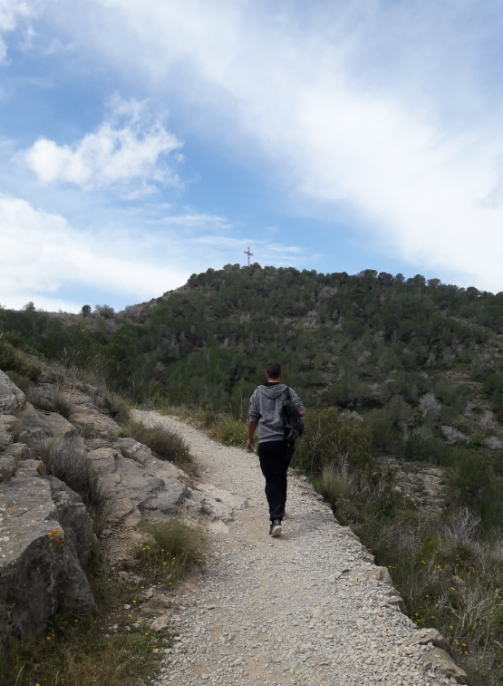
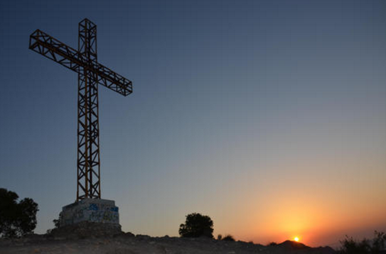
Salvo en un tramo en el que la elevada inclinación de la ladera se salva con el zigzag de la senda, el resto va subiendo de una forma moderada y prácticamente constante. El sendero está bastante transitado y no ofrece dudas. Serpentea por la cara norte de la sierra, entre pinos, para subir a un collado, donde encontramos un poste señalizador que nos indica que estamos en el punto II de la Senda de la Muela. Desde este punto podemos subir a la Cruz de la Muela en cinco minutos, donde destaca una enorme cruz metálica.
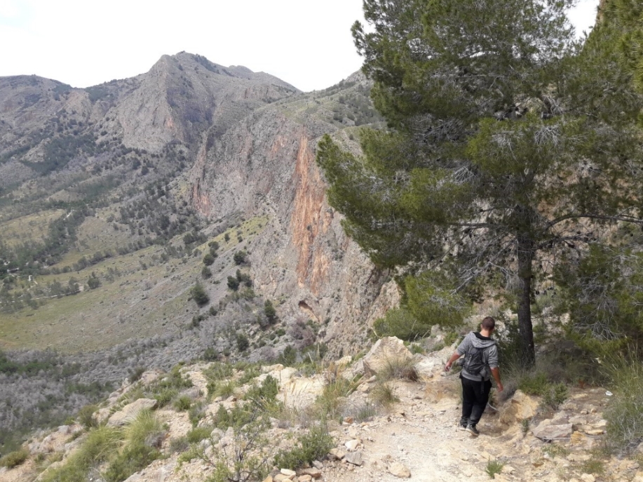
Ahora la ruta continúa por una senda que discurre cerca de la cima de la sierra, pero por la cara Norte, mucho más poblada de pinos y fresca que la Sur. Se sigue, en todos los cruces de sendas, por la cara Norte. Al llegar a la pinada, NOS ENCONTRAMOS CON UN CRUCE DE SENDAS IMPORTANTE: La ruta sigue hacia la izquierda, por la VARIANTE 02, dejando a la derecha la senda principal que se interna en la pinada. Se distingue sobre la ladera del Barranco Granado el zigzag que marca la senda de bajada MUY PRONUNCIADA.
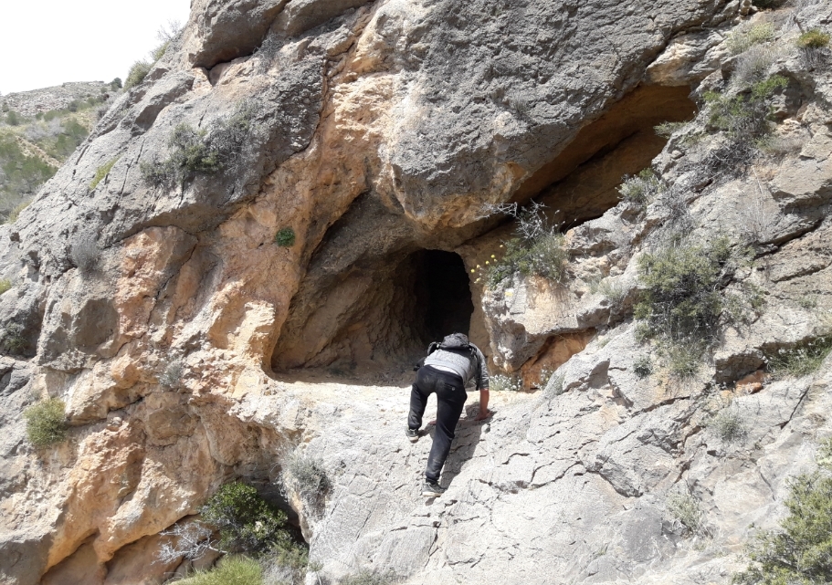
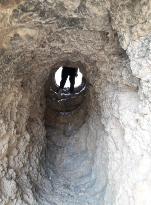
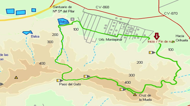
Llegamos por fin a un punto importante en la ruta El Paso del Gato, una zona algo más abrupta en la que nos tenemos que ayudar con las manos para subir (trepada ALGO MAS COMPLICADA) y después pasar por un par de oquedades en la roca. Cruzamos por un orificio excavado en la roca por el hombre, sin duda el momento mas espectacular de la ruta.
Tras el Paso del Gato, el sendero se bifurca otra vez. En este cruce, se deja a la izquierda la senda que lleva a la Peña de Orihuela o Leja Millamón.TOMAMOS LA SENDA A LA DERECHA en una importante subida. Se sigue hacia la derecha para continuar la ruta primero en una fuerte pero sencilla ascensión y tras pasar a la cara sur, bajar el Barranco Granado. El sendero, entre pinos, serpentea por el barranco hasta llegar a una pista de servicio para los cultivos de naranjos y limoneros de la zona. Seguimos por la pista, pasando junto a varias balsas de riego hasta llegar al Santuario de Nª Sª del Pilar, en la cara norte de la sierra, al que se accede por pista asfaltada con entrada desde la CV-868.
Desde el Santuario, regresamos por la pista asfaltada hacia la urbanización y giramos a la izquierda por la calle Melilla. La calle atraviesa de oeste a este las obras y tiene un kilómetro de longitud aproximadamente. Cuando llegamos a la calle La Coruña, giramos a la izquierda, y seguimos hasta la calle Orense, a la derecha. Continuamos por la calle Orense hasta el final, llegando de regreso al parking.
FICHA TECNICA DE LA RUTA
- Actividad: Ruta de Media Montaña con sendas, veredas y un trepado de baja dificultad.
- Sierra: Sierra de Orihuela
- Posición Geológica Regional: Cordilleras Béticas - Zonas Externas - Prebético
- Comarca: Vega Baja del Segura, Alicante
- Distancia: 10.1 km
- Punto de Partida: Parking urbanización Montepinar. .
- Punto de Llegada: Parking urbanización Montepinar.
- Circular: Si
- Desnivel superado: Inicial 62 m. máximo 475 m.
- Caminos Homologados: Ruta PR CV 59 y sendas
- Itinerario: Urbanización Montepinar – Senda PR-CV-59 hasta Cruz de LA Muela – senda descendente hacia Pinar – Paso del gato – Senda derecha hacia barranco Granado – Senda hacia balsas de riego – vuelta a Urbanización Montepinar.
- Calificación Técnica: Media. El Paso del gato requiere y conocimiento y cuidado algo mayor.
- Calificación de exigencia Física: Media
-
Recomendaciones: Esta ruta y en general el senderismo de montaña requiere una adecuada preparación física, una buena planificación previa de la ruta en el sentido de conocer a donde se va y por donde, una buena reserva alimentaría y liquida (no confiarse nunca en que nos podamos encontrar fuentes) y desde luego ir provisto del material adecuado (prendas, calzado…). E incluso aspectos tales como la meteorología y el saber seleccionar la ruta según la época del año son importantes tenerlos en cuenta a la hora de acometer una ruta de montaña de manera segura y por ende satisfactoria.
RECOMENDABLE DESCARGAR LA RUTA DE WIKILOC con el recorrido a seguir. Puede descargarse en el siguiente ENLACE http://es.wikiloc.com/wikiloc/view.do?id=9324504
LOS CACHÉS
Se trata de UNA SERIE DE 30 cachés, de los cuales 25 son formato preforma cilíndrica con cierre rosca, tamaño pequeño, unos 9 x 4 cm, en cuyo interior encontramos sólo el logbook y un lápiz. Ademas, 5 cachés más formato tupper pequeño, de 11 x 8 x 5 cm. que contiene logbook para logs, FOLLETO EXPLICATIVO de en que consiste en geocaching, LAPIZ (Gracias de todo corazón a IKEA), SACAPUNTAS y algún pequeño REGALO.

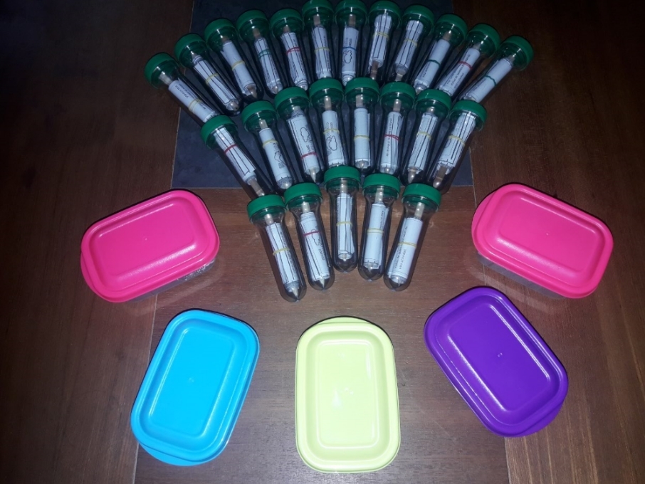
Inicialmente en los cachés nº 10, 13, y 22 se depositan TRAVEL BUGS para ser movidos a otros cachés. Todo el contenido se encuentra protegido por bolsa de cierre hermético.POR FAVOR, UTILIZAR EL MINIMO ESPACIO POSIBLE DE LOS LOGBOOKS PARA LOS LOGS, de esta forma durará más. Es muy importante volver a dejarlo tal como se encontró. En todos los listing hay FOTOS SPOILER correspondientes a cada uno de ellos.
ES MUY DE DESEAR Y DE AGRADECER UN REGISTRO DE VUESTRAS VISITAS QUE SEA ALGO MAS QUE UN SIMPLE :
"TFTC ;)" o "EASY FOUND"
COLOCAR UNA SERIE DE ESTE ESTILO REQUIERE MUCHO TIEMPO, DEDICACIÓN Y DINERO, MUCHO MAS QUE EL QUE SE TARDA EN HACER UN BUEN LOG.
Gracias y FELIZ BUSQUEDA!!


CIRCULAR TRAIL IN SIERRA DE ORIHUELA
This series of 30 cachés has as objective to realize a circular route of mountain along the Mountain range of Orihuela, with beginning and end in the Urbanization Montepinar, visiting the Cross of the Muela and the Step of the Cat. For this we will continue in most of the route Route PR-CV-59. The path runs along paths and paths delimited and marked with paint. I hope you enjoy absolutely spectacular views.
ATTENTION: It is a medium-high difficulty course, physically demanding and requires experience in the mountains, as well as the appropriate equipment. NOT FIT for children under 12 years or people with vertigo or respiratory or cardiovascular problems.
THE SIERRA DE ORIHUELA
The Sierra de Orihuela is a mountainous line between the southern border of the province of Alicante and the eastern end of Murcia. It belongs to the region of Bajo Segura, in particular to the municipal terms of Orihuela and Santomera.
The maximum height is 634 m. Of height at its maximum point. Some of its peaks are the Muela, Peak of the Cross of the Muela (564 m.), Peak of the Cuervo, Peak of the Eagle (634 m.).
Geologically, Is located within the bético domain. Together with the Callosa mountain range it forms a mountainous alignment composed of blocks of Triassic dolomitic limestones, which emerge isolated in the middle of the alluvial plain. Its forms are abrupt and very fragmented.3 Since ancient times, these mountains have been the object of mining activity, being frequent the wells and galleries that we can still find. Fundamentally, along with some abandoned gypsum and limestone farms, iron ore was extracted and in a few native gold sites.
The whole mountain range presents numerous cavities, coats and caves of variable development, which confers to the abrupt landscape a certain singularity and geomorphological beauty.
Hydrologically, The whole area is subject to high sunshine in the summer months. This factor, together with the scarce rainfall, hinders the existence of permanent sources and watercourses. Only the source of San Cristóbal can contain some water after important rains.
Respect the fauna, The birds are the best represented group, emphasizing the presence of Bonelli's eagle (Hieraetus fasciatus) and eagle, species that are seriously threatened and that nest in the area, owl (Bubo bubo), small owl (Asio otus), kestrel vulgar Falco tinnunculus), hawk (Accipiter nisus) and the peregrine falcon (Falco peregrinus). In cornial formations they house rare birds such as the horned trumpeter (Bucanetes githagineus) and the rat (Coracias garrulus).
Among the mammals include the presence of the fox, the wildcat (Felis sylvestris), the mountain goat and the hare.
the flora is one of the most remarkable biological variables of the ecosystem that hosts this Sierra, not only because of the large number of species that inhabit it, among which is the Cuckoo Cattail (Sideritis glauca) and Centaurea saxícola Appear abundantly in the mountains of Callosa and Orihuela.
It is also worth mentioning the presence of very peculiar plant communities, as is the case of the "cornical", or the "oroval", that in all the Valencian Community only appear in these mountain ranges. Plants that have curious adaptations to local arid conditions such as defoliation in summer instead of autumn. All this without neglecting the appearance of hundreds of other species with greater geographical distribution, many of which have great aesthetic, aromatic and medicinal value.
The botanical wealth of the mountains motivated the community administration to declare two micro-reserves of flora in order to guarantee the conservation of these species and their habitats.
Depending on the height, orientation of the slopes, type of substrate or conditions of insolation there are different types of plant communities with different species that represent them, so in the higher areas we can find pastures, spartans or tomillaries and in the areas Low where some soil accumulates appear conifer forests and scrubland Alicante like cornicales, espinares, genistares etc ...
In the most shady ravines you can find species of ferns like some of the genera Cheilantes, Asplenium or Ceterach and in certain seasons we can enjoy the ephemeral presence of some annuals as spectacular as the orchids.
THE TRAIL
The beginning of the path of ascent to the Cross of the Muela is at the end of the Urbanization Montepinar. And it is marked by a signal. It begins with a dirt road, along with some lemon trees. Then you reach a path in good condition and easy to follow, as it is widely used by the people of Orihuela and its districts.
Except in a section where the high slope of the slope is saved with the zigzag of the path, the rest goes up in a moderate and practically constant. The trail is quite busy and offers no doubts. Serpentea on the north side of the mountain range, among pine trees, to climb a hill, where we find a signpost that indicates that we are at point II of the Path of the Muela. From this point we can climb to the Cruz de la Muela in five minutes, where a huge metallic cross stands out.
Now the route continues along a path that runs near the top of the mountain range, but on the North side, much more populated with pine and cool than the South. It follows, in all crossings of paths, by the north face. When you reach the pinnacle, we find a trail crossing. IMPORTANT: The route continues to the left, through the VARIANT 02, leaving to the right the main path that goes into the pinewood. It is distinguished on the slope of the Barranco Granado the zigzag that marks the path of descent VERY HARD..
We finally arrive at an important point on the route El Paso del Gato, a somewhat more abrupt area where we have to help with the hands to climb (climbed SOMETHING MORE COMPLICATED) and then go through a couple of hollows in the rock. We crossed an orifice excavated in the rock by the man, undoubtedly the most spectacular moment of the route.
After the Paso del Gato, the trail forks again. At this junction, left to the left that leads to the Peña de Orihuela or Leja Millamón.TOMAMOS THE RIGHT PATH in an important ascent. Follow to the right to continue the route first in a strong but simple ascent and after passing to the south face, go down the Barranco Granado. The path, among pine trees, meanders along the ravine until reaching a service trail for orange and lemon groves in the area. We continue along the track, passing along several irrigation rafts until we reach the Sanctuary of Nª Sª del Pilar, on the north side of the mountain range, which is accessed by asphalted track with entrance from CV-868.
From the Sanctuary, we return by the asphalted track towards the urbanization and we turn left by the street Melilla. The street crosses from west to east works and is approximately one kilometer long. When we get to La Coruña street, turn left, and continue to Orense street, on the right. We continue along Orense Street until the end, arriving back at the parking lot.
TECHNICAL DATA SHEET OF THE ROUTE
- Actividad: Ruta de Media Montaña con sendas, veredas y un trepado de baja dificultad.
- Sierra: Sierra de Orihuela
- Posición Geológica Regional: Cordilleras Béticas - Zonas Externas - Prebético
- Comarca: Vega Baja del Segura, Alicante
- Distancia: 10.1 km
- Punto de Partida: Parking urbanización Montepinar. .
- Punto de Llegada: Parking urbanización Montepinar.
- Circular: Si
- Desnivel superado: Inicial 62 m. máximo 475 m.
- Caminos Homologados: Ruta PR CV 59 y sendas
- Itinerario: Urbanización Montepinar – Senda PR-CV-59 hasta Cruz de LA Muela – senda descendente hacia Pinar – Paso del gato – Senda derecha hacia barranco Granado – Senda hacia balsas de riego – vuelta a Urbanización Montepinar.
- Calificación Técnica: Media. El Paso del gato requiere y conocimiento y cuidado algo mayor.
- Calificación de exigencia Física: Media
-
Recomendations: This route and in general the mountain trekking requires an adequate physical preparation, a good advance planning of the route in the sense of knowing where it goes and where, a good food and liquid reserve (never trust that we can find Sources) and of course be supplied with the right material (clothing, footwear ...). And even aspects such as meteorology and the know how to select the route according to the time of the year are important to take them into account when undertaking a mountain route safely and therefore satisfactory.
RECOMMENDED DOWNLOAD THE WIKILOC ROUTE with the route to follow. It can be downloaded in the following LINK http://es.wikiloc.com/wikiloc/view.do?id=9324504
THE CACHÉS
It is a SERIES OF 30 cachés, of which 25 are cylindrical preform format with thread closure, small size, about 9 x 4 cm, inside which we find only the logbook and a pencil. In addition, 5 caches plus small tupper format, 11 x 8 x 5 cm. Which contains logbook for logs, EXPLANATORY BROCHURE in which consists of geocaching, LAPIZ (Thank you with all my heart to IKEA), SHARPNESSES and some small GIFT.
Initially in caches nº 10, 13, and 22 TRAVEL BUGS are deposited to be moved to other caches. All content is protected by a sealed bag. PLEASE USE THE LOWEST LOGBOOKS SPACE FOR THE LOGS, so it will last longer. It is very important to leave it as it was found. In all the listings there are PHOTOS SPOILER corresponding to each one of them.
IT IS VERY TO DESIRE AND THANK A REGISTRY OF YOUR VISITS THAT IS SOMETHING MORE THAN A SIMPLE:
"TFTC ;)" o "EASY FOUND"
PLACING A SERIES OF THIS STYLE REQUIRES A LONG TIME, DEDICATION AND MONEY, MUCH MORE THAN THE ONE THAT IT TAKES TO MAKE A GOOD LOG.
Thanks and HAPPY SEARCH !!