1) Les crues de l'Indre, parlons-en !!! EarthCache
1) Les crues de l'Indre, parlons-en !!!
-
Difficulty:
-

-
Terrain:
-
Size:  (other)
Please note Use of geocaching.com services is subject to the terms and conditions
in our disclaimer.
Les crues de Cormery. 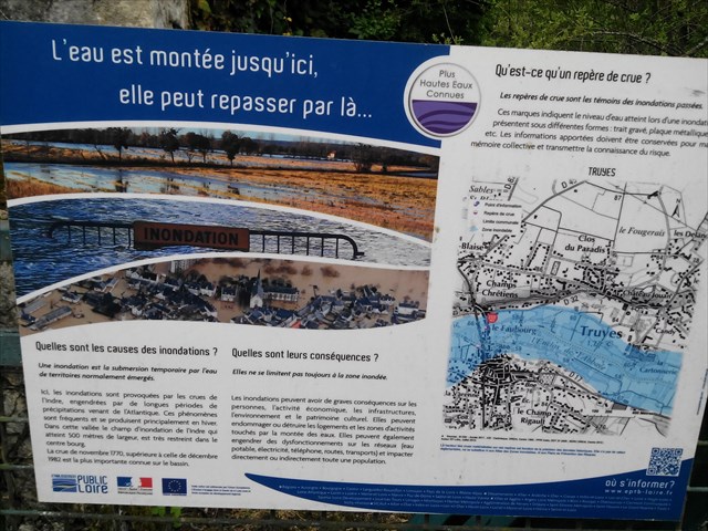 Améliorer la conscience et la connaissance du risque d'inondation auprès des riverains est une étape indispensable pour prévenir ce risque.
La crue correspond à la montée des eaux d'un cours d'eau.
L'inondation au phénomène qui en résulte, l'eau débordant, se répandant sur les terrains alentours.
CRUES ET INONDATIONS...
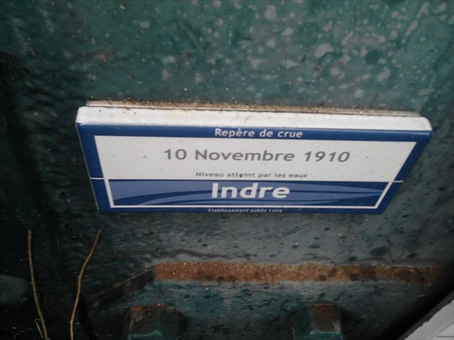
La notion d'inondation appelle celles de lit mineur et lit majeur d'un cours d'eau : - le lit mineur est la partie du lit du cours d'eau comprise entre des berges franches ou bien marquées, dans laquelle l'intégralité de l'écoulement s'effectue la quasi totalité du temps en dehors des périodes de très hautes eaux et de crues débordantes. - le lit majeur est le lit maximum qu'occupe un cours d'eau dans lequel l'écoulement ne s'effectue que temporairement lors du débordement des eaux hors du lit mineur en période de très hautes eaux en particulier lors de la plus grande crue historique.  Cette conjoncture est due à des précipitations en forte quantité, auxquelles peut s'ajouter un sol imperméable ou devenu imperméable suite à une sécheresse importante : le sol n'absorbe plus la quantité d'eau qui lui parvient. Les crues peuvent être importantes compte tenu de la taille déjà grande du bassin versant. Elles sont cependant nettement moindres que celles qui affectent les affluents de plaine de la partie occidentales du bassin de la Loire, celles-ci coulant sur le vieux socle primaire armoricain, imperméable. C'est dans cet esprit que plusieurs communes de la vallée de l'Indre ont décidé de mettre en place des repères de crue, avec l'aide technique et financière de l'Établissement public Loire et du Syndicat d'aménagement de la vallée de l'Indre (Savi). Ces repères indiquent le niveau des plus hautes eaux connues, à savoir la crue de novembre 1770 ou celle de la crue centennale de 1982, et éventuellement celui d'autres crues importantes de l'Indre. Des repères sont déjà posés à Courçay, Cormery, Esvres, Veigné, Montbazon, Saché et Azay-le-Rideau.
LES REPERES DE CRUES. 
 RAPPEL: PAS DE BOITE A TROUVER SUR PLACE...
POUR VALIDER LE FOUNDT-IT, REPONDEZ AUX QUESTIONS SUIVANTES:
1) Différence entre crue et inondation ?
RAPPEL: PAS DE BOITE A TROUVER SUR PLACE...
POUR VALIDER LE FOUNDT-IT, REPONDEZ AUX QUESTIONS SUIVANTES:
1) Différence entre crue et inondation ?
2) Largeur du champ d'inondation de l'Indre . (en mètres)?
3) Qu'appelle-t-on "notion d'inondation" ?
4) Au WP: Hauteur d'eau des repères en photo situés sur l'échelle de crue (en mètres) et altitude du WP ?
5) Photo optionnelle près du WP. (pas de l'échelle de crue) SVP)
Loguez cette cache "Found it" et envoyez-moi vos propositions de réponses soit via mon profil, soit via la messagerie geocaching.com (Message Center), et je vous contacterai en cas de problème.
BONNE DECOUVERTE...
 Cormery floods.
Improving awareness and awareness of flood risk among local residents is an essential step in preventing this risk.
The flood corresponds to the rise of the waters of a watercourse.
The flood to the resulting phenomenon, the overflowing water, spreading over the surrounding terrain.
CRUES AND FLOODS ..
The term "flood" refers to those of a minor bed and a major bed of a watercourse: - the minor bed is that part of the bed of the watercourse between banks or marked margins, in which the entirety of The flow takes place almost all the time outside the periods of high waters and flooding overflows. - the major bed is the maximum bed occupied by a watercourse in which the flow occurs only temporarily during the overflow of the waters out of the minor bed during periods of very high waters, particularly during the greatest flood historical.
Cormery floods.
Improving awareness and awareness of flood risk among local residents is an essential step in preventing this risk.
The flood corresponds to the rise of the waters of a watercourse.
The flood to the resulting phenomenon, the overflowing water, spreading over the surrounding terrain.
CRUES AND FLOODS ..
The term "flood" refers to those of a minor bed and a major bed of a watercourse: - the minor bed is that part of the bed of the watercourse between banks or marked margins, in which the entirety of The flow takes place almost all the time outside the periods of high waters and flooding overflows. - the major bed is the maximum bed occupied by a watercourse in which the flow occurs only temporarily during the overflow of the waters out of the minor bed during periods of very high waters, particularly during the greatest flood historical. 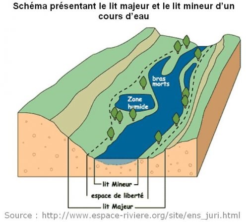 This situation is due to precipitation in large quantities, to which can be added an impermeable or impermeable soil due to a drought: the soil no longer absorbs the quantity of water that reaches it. Floods can be significant given the already large size of the watershed. They are, however, much smaller than those affecting the plain tributaries of the western part of the Loire basin, flowing over the old, impermeable Armorican basement. It is in this spirit that several communes in the Indre valley have decided to set up flood marks, with the technical and financial assistance of the Loire Public Institution and the Valley The Indre (Savi). These markers indicate the level of the highest known waters, namely the flood of November 1770 or the flood of the centennial flood of 1982, and possibly that of other important floods in Indre. Landmarks are already laid in Courçay, Cormery, Esvres, Veigné, Montbazon, Saché and Azay-le-Rideau.
CRUISE MARKINGS.
REMINDER: NO BOX TO BE FIND ON PLACE ..
TO VALIDATE THE FOUNDT-IT, ANSWER THE QUESTIONS
1) Difference between flood and flood?
This situation is due to precipitation in large quantities, to which can be added an impermeable or impermeable soil due to a drought: the soil no longer absorbs the quantity of water that reaches it. Floods can be significant given the already large size of the watershed. They are, however, much smaller than those affecting the plain tributaries of the western part of the Loire basin, flowing over the old, impermeable Armorican basement. It is in this spirit that several communes in the Indre valley have decided to set up flood marks, with the technical and financial assistance of the Loire Public Institution and the Valley The Indre (Savi). These markers indicate the level of the highest known waters, namely the flood of November 1770 or the flood of the centennial flood of 1982, and possibly that of other important floods in Indre. Landmarks are already laid in Courçay, Cormery, Esvres, Veigné, Montbazon, Saché and Azay-le-Rideau.
CRUISE MARKINGS.
REMINDER: NO BOX TO BE FIND ON PLACE ..
TO VALIDATE THE FOUNDT-IT, ANSWER THE QUESTIONS
1) Difference between flood and flood?
2) Width of the Indre flood field. (In meters)?
3) What is called "flooding"?
4) At the WP: Water height of the photo marks located on the flood scale (in meters) and altitude of the WP?
5) Optional photo near the WP. (Not flood scale) Please)
Log in this "Found it" cache and send me your suggestions for answers either via my profile or via the geocaching.com message center, and I will contact you if there is a problem.
 BELLE BALADE, JE VOUS ATTENDS.../BEAUTIFUL BALAD, I WAIT YOU ..
Additional Hints
(Decrypt)
Ibhf eraqer à y'havdhr JC cbhe eécbaqer nhk dhrfgvbaf !!!
**************
Tb gb gur havdhr JC gb nafjre dhrfgvbaf !!!