English descriptions will follow after the Japanese ones.
[Japanese]
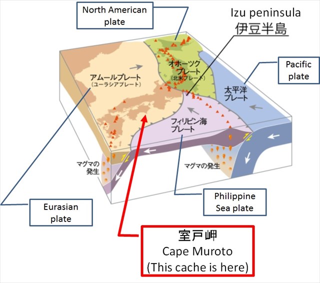
室戸は、2011年9月11月に世界ジオパークに指定されました。室戸ジオパークの沖合140km先では、海洋プレートであるフィリピン海プレートが、大陸プレートであるユーラシアプレートに衝突してその下に沈み込む沈み込み帯となっています(下図)。この沈み込み帯は、南海トラフと呼ばれています。
プレートの移動に起因して、室戸ユネスコ世界ジオパークでは、大地震の発生とその痕跡、付加体の形成、海底で生じた斑レイ岩などの、興味深い地学的特徴を観察することが出来ます。
このアースキャッシュでは、プレートの移動に起因して発生した大地震の痕跡を観察しましょう。
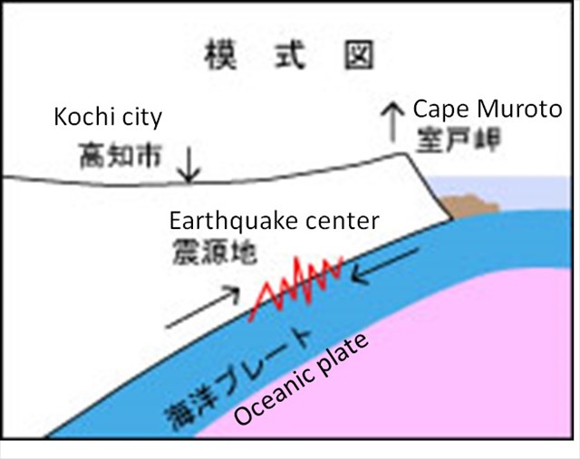
南海トラフでは、100~150年間隔でマグニチュード8クラスの巨大地震が発生しています。巨大地震が発生すると、その反動により、室戸周辺は大きく隆起する一方、高知市付近は沈下します(下図)。約1000年前に発生した巨大地震では、室戸岬が約5m程隆起したことが分かっています。公開座標付近は、現在では海面から離れていますが、かつては海面付近にありました。その証拠として、公開座標付近には、波打ち際に生息するヤッコカンザシという生物の巣の化石が残っているのを観察することができます。
タスク
このアースキャッシュをFoundするには、以下のクイズの回答をキャッシュオーナーに送ってください。
Quiz 1
公開座標付近では、ヤッコカンザシの巣の化石以外に、この場所がかつて波打ち際であった証拠が少なくとも2つあります。それらの証拠の少なくとも1つをお答えください。
Quiz 2
ヤッコカンザシは波打ち際にしか巣を作らないため、巨大地震の発生に起因して地面が急激に隆起すると、ヤッコカンザシが巣を作る位置も急激に変化します。例えば、地面が1m隆起すると、それまで巣があった位置から1m下の位置に巣が作られます。このとき、上の巣の位置と下の巣の位置との間は、波打ち際であった時期が無いために、ヤッコカンザシの巣は存在しません。Additional Waypoint, "Fossils"の場所では、巨大地震の前後のヤッコカンザシの巣の化石、すわなち、異なる高さに残されたヤッコカンザシの巣の化石を観察することができます。この高さの違いが、一回の巨大地震によって生じた隆起の量を示しています。このAdditional Waypointで観察される巣の化石の位置の差は何m位でしょうか?地震のエネルギーの大きさを感じましょう!
[English]
Muroto was designated as the Global Geopark on September 18, 2011. At ~140 km off the coast of Muroto Geopark, the oceanic plate, the Philippine Sea Plate, collides with the continental plate, the Eurasian Plate, and sinks below the Eurasian Plate, and then becomes a subduction zone (see the figure below). This subduction zone is called as Nankai Trough.
In the Muroto UNESCO Global Geopark,due to the plate movement, you can observe interesting geological features, such as the traces of major earthquakes, the formation of accretionary complexes, the gabbroic rocks formed at the bottom of sea.
In this earthcache, let's observe the traces of major earthquakes caused by the movement of the plate.
In the Nankai Trough, huge earthquakes of magnitude 8 classes occur at intervals of 100 to 150 years. When a huge earthquake occurs, due to its reaction, the area around Muroto upthrusts prominently, while the area around Kochi City subsides (see the figure belwo). By the huge earthquake that occurred about 1000 years ago, it is known that Muroto Cape rose about 5 m. The vicinity of the published coordinates is now far from the sea level, but once it was near the sea level. As the evidence, near the published coordinates, you can observe the fossils of the nests of the living creatures named "Yakko Kanzashi" which live at the water's edge.
Task
For claiming your "Found" of this earthcache, please send your answers for the quizzes below to the cache owner.
Quiz 1
Around the published coordinates, you can observe at least two evidences that this place was once at the water's edge other than the fossil of the Yakko Kanashi's nests. Please answer at least one of the two evidences.
Quiz 2
Since Yakko Kanzashi creates its nests only at the edge of water, if the land upthrusts rapidly due to the occurrence of a huge earthquake, the location at which Yakko Kanzashi makes its nests also changes drastically. For example, when the land rises 1 m suddenly by an earthquake, nests are created 1 m below the position where the nests were before the earthquake. In this scenario, the area between the upper nests and the lower nests has no chance to be at the water's edge, thus has no Yakko Kanzashi's nest there. At the Additional Waypoint, "Fossils," you can observe the fossils of the Yakko Kanzashi's nests before and after the huge earthquake, that is, the fossils of the Yakko Kanashi's nests remaining at different heights. This difference in height shows the amount of uplift caused by one huge earthquake. What is the difference in positions of the fossils of the nests observed at the Additional Waypoint? Let's feel the magnitude of earthquake energy!