La Earthcache / The Earthcache
Une petite île à l'une des extrémités du continent eurasiatique, l'île d'Ouessant (Enez Eussa), dresse ses falaises à une vingtaine de kilomètres de la côte occidentale du pays de Léon: elle marque l'ultime avancée, dans l'Atlantique, du socle armoricain émergé.
Elle est la terre la plus occidentale de la France métropolitaine et l'un des promontoires ruiniformes de l'immense continent eurasiatique.
► Contexte géologique général
L'existence même de cette île, surgissant d'une centaine de mètres à l'entrée de la Manche, semble en relation avec le rejeu de failles transversales.
Ces mouvements tectoniques puissants sont à l'origine de plusieurs structures faillées amenant en contact anormal différents types de roches, principalement de nature granitique (granite à deux micas de Lokeltas, granite porphyroïde rose,...), surtout dans la partie septentrionale, avec une dépression médiane creusée dans des roches métamorphiques (micaschistes...), mais également des formations intrusives originales comme la trondhjémite ou de la pegmatite.
Cette petite série de EarthCaches va nous permettre de faire un rapide aperçu de cette diversité géologique de l'île.
Ce second opus est l'occasion de découvrir un granite particulier, la formation du granite porphyroïde rose à Lampaul, apparenté au célèbre granite de la côte de Granite rose de Ploumanac'h.

► Caractéristiques du granite porphyroïde rose
Ce granite se distingue de tous les autres granites bretons par l'abondance de ses feldspaths roses (potassiques), trapus, pluricentimétriques (jusqu'à 4-5 centimètres parfois) - qui lui confèrent un net cachet porphyroïde - dans un fond à grain moyen où l'on distingue un second feldspath (calco-sodique), blanchâtre, le quartz gris "gros sel" et les innombrables paillettes du mica biotite à vif éclat noirâtre.
La notion de porphyroïde vient de la taille de ces cristaux ; on parle alors de phénocristaux - cristaux aisément reconnaissables à l’œil nu.

Cette couleur rose de ce granite est due en grande partie à la présence d’oxyde de fer (hématite) dans le réseau cristallin du feldspath alcalin.
La mise en place de ce granite dans une faille restée longtemps active l'a soumis à de nombreuses forces appliquées lors de l’activité tectonique de cette faille. Du fait de ces contraintes, les minéraux constituant cette roche sont en grande partie broyés : c’est la "mylonitisation" du granite.
Le feuillet granitique allongé de Lampaul présente des degrés variables dans la cataclase. De manière général, l'écrasement n'est jamais fluidal (forme allongé), mais toujours plus ou moins bréchique (forme plus rectangulaire).
► Formation
Le granite est une roche "plutonique" (venue des profondeurs), mais pas éruptive : c'est l'érosion qui la fait apparaître en surface.
La formation du granite rose de Lampaul prend la forme d'une massue de plus de 5 km de long, s'élargissant vers l'WSW.
Cette bande de granite est située en jonction entre le leucogranite de Lokeltas (granite blanc) au nord et du micaschiste au sud. Le granite mylonitisé se situe au niveau d’une faille restée longtemps active.
Cette bande de granite "rose" traversant Ouessant fait partie de la ceinture de granites roses du Massif Armoricain (Ploumanach, Aber Ildut) et représente l’élément le plus occidental de cette ceinture.

Sa mise en place, contrôlée par le grand accident linéamentaire nord-armoricain, s’est déroulée au cours de la formation de la chaîne hercynienne (aux alentours de -280-300 millions d’années).
En effet, à l’époque le granite rose était enfouie sous une chaîne de montagne. Le magma est remonté et a formé une chambre magmatique située à 5 km de profondeur.
L'érosion de la chaîne hercynienne, active depuis sa surrection, a raboté la chaîne de montagne, amenant son coeur à l'air libre.

A small island at one end of the Eurasian continent, the island of Ouessant (Enez Eussa), draws its cliffs about twenty kilometers from the western coast of the country of Leon: it marks the ultimate The Atlantic, the Armorican basement emerged.
It is the most western land of metropolitan France and one of the ruiniform promontories of the immense Eurasian continent.
► Local Geological Context
The very existence of this island, emerging from a hundred meters at the entrance of the Channel, seems in relation to the replay of transverse faults.
These powerful tectonic movements are at the origin of several faulty structures bringing into contact abnormal different types of rocks, mainly of granite nature (granite with two micas of Lokeltas, pink porphyroïde granite, ...), especially in the northern part, with A median depression excavated in metamorphic rocks (micaschistes ...), but also original intrusive formations such as trondhjemite or pegmatite.
This small series of EarthCaches will allow us to give a quick overview of this geological diversity of the island.
This second opus is the occasion to discover a particular granite, the formation of the porphyroid pink granite in Lampaul, related to the famous granite of the pink Granite coast of Ploumanac'h.
► Characteristics of pink porphyroid granite
This granite is distinguished from all the other Breton granites by the abundance of its pink (potassic), stocky, pluricentimetric (up to 4-5 centimeters sometimes) feldspars - which give it a distinct porphyroid character - in a medium grain Where a second whitish feldspar (calco-sodium) is distinguished, the gray quartz "coarse salt" and the innumerable sequins of the biotite mica with sharp blackish shine.
The notion of porphyroid comes from the size of these crystals; We speak then of phenocrystals - crystals easily recognizable to the naked eye.
This pink color of this granite is due in large part to the presence of iron oxide (hematite) in the crystal lattice of the alkaline feldspar.
The placement of this granite in a fault that remained active for a long time exposed it to many forces applied during the tectonic activity of this fault. Because of these constraints, the minerals constituting this rock are largely crushed: this is the "mylonitization" of the granite.
The elongated granite leaf of Lampaul presents varying degrees in the cataclase. In general, the crushing is never fluid (elongated form), but always more or less breccia (more rectangular form).
► Formation
Granite is a rock "plutonic" (coming from the depths), but not eruptive: it is erosion that makes it appear on the surface.
The formation of the pink granite of Lampaul takes the form of a club more than 5 km long, widening towards the WSW.
This strip of granite is located at the junction between the leukogranite of Lokeltas (white granite) to the north and the mica schist to the south. The mylonitized granite is located at a fault that has remained active for a long time.
This band of "rose" granite crossing Ouessant is part of the pink granite belt of the Massif Armoricain (Ploumanach, Aber Ildut) and represents the most western element of this belt.
Its establishment, controlled by the great North-American Armamentic accident, took place during the formation of the Hercynian chain (around -280-300 million years ago).
Indeed, at that time the pink granite was buried under a mountain range. The magma rose and formed a magmatic chamber located 5 km deep.
The erosion of the Hercynian range, which has been active since its erection, has planted the mountain range, bringing its heart to the open air.
► Sources bibliographiques / Bibliographical sources
Les Questions / The Questions
La lecture attentive du descriptif de la cache, ainsi qu'une observation des éléments de terrain et un peu de déduction sont normalement suffisants pour répondre aux questions de cette EarthCache.
A careful reading of the description of the cache, as well as observation of terrain features and some deduction is usually sufficient to answer questions of this EarthCache.
Questions pour valider :"Granite rose à Lampaul"
Questions to validate: "Pink granite in Lampaul"
Point 1 : N 48° 27.255 W 005° 05.833
Descendez le long de la rampe à bateaux. Sur la droite vous avez un affleurement de roche (photo WP1_large).
Descend along the boat ramp. On the right you have a rock outcrop (photo WP1_large).
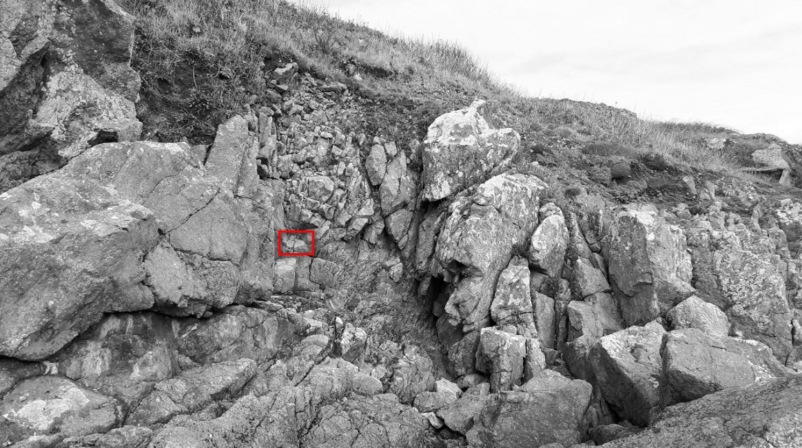
Allez observer de plus près la zone rouge (photo WP1_zoom).
Take a closer look at the red zone (photo WP1_zoom).
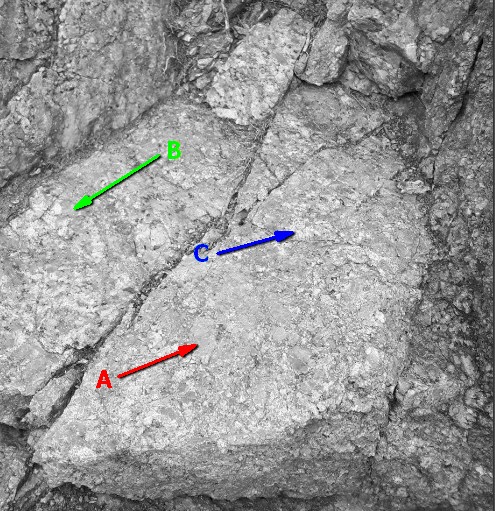
- Question 1 : Décrivez les minéraux A, B et C qui composent cette roche. Identifiez les.
- Question 1 : Describe the minerals A, B and C that make up this rock. Identify them.
- Question 2 : Quelle est la taille des plus gros cristaux ? Quel qualificatif pouvez-vous leur donner ?
- Question 2 : What is the size of the largest crystals? What qualifier can you give them?
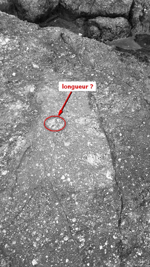
Point 2 : N 48° 27.247 W 005° 05.861
Remonter sur la falaise et dirigez-vous vers le bout de la route. Un affleurement représentatif se trouve à droite de la route au début de la falaise (photo WP2_large).
Go up the cliff and head towards the end of the road. A representative outcrop is to the right of the road at the beginning of the cliff (photo WP2_large).

- Question 3 : Quelle est la couleur de l'ensemble ? A quoi est-elle due ?
- Question 3 : What is the color of the rock? What is it due to?
- Question 4 : Quelle est la longueur de l'ensemble cristallin dans le rond rouge (photo WP2_zoom) ?
- Question 4 : What is the length of the crystalline set in the red circle (photo WP2_zoom) ?
Vous pouvez vous loguer sans attendre notre confirmation,
mais vous devez nous envoyer les réponses en même temps soit par mail via notre profil (
fafahakkai), soit via la messagerie geocaching.com (Message Center).
S'il y a des problèmes avec vos réponses nous vous en ferons part.
Les logs enregistrés sans réponses seront supprimés.Une photo de vous ou de votre GPS avec le port de Lampaul en arrière plan serait la bienvenue, mais n'est pas obligatoire.
You can log this cache without waiting for our confirmation, but you must send us the answers at the same time, by e-mail via our profile (fafahakkai) or by the system of Message Center of geocaching.com.
If there is a problem with your answers we will notify you. The logs recorded without answers will be deleted.
A photo of you or your GPS with the port of Lampaul in the background would be welcome but is not mandatory.
Rappel concernant les « Earthcaches »: Il n'y a pas de conteneur à rechercher ni de logbook à renseigner. Il suffit de se rendre sur les lieux, de répondre aux questions ci-dessus et de nous renvoyer les réponses.
Reminder concerning "Earthcaches": there is neither a container to look for nor a logbook to sign. One need only go to the location, answer to the differents questions and send us the answers.