Hydrology
This EarthCache lesson will explain a bit about hydrology. Hydrology is the science which deals with the distribution and movement of water on the earth including that in the atmosphere and below the surface of the earth. For this lesson, we are going to focus on the movement just below the surface and where the water just below the surface intersects the surface.
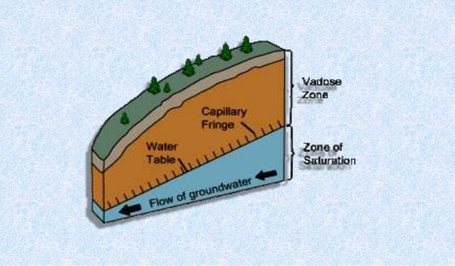
Water Table or Groundwater Table
The water table is the upper level of an underground surface in which the soil or rocks are permanently saturated with water. The water table separates the groundwater zone that lies below it from the capillary fringe that lies above it. The water table fluctuates both with the seasons and from year to year due to climatic variations. It is also affected by the amount of precipitation gained from weather and precipitation used by vegetaton.
Water Table / Surface
Water from rain or other precipitation soaks into the ground and becomes groundwater. This groundwater becomes part of the water table. The water table can intersect with the surface, on a side of a hill for example. Where this intersection occurs, water can flow out. This flow of water can be either a seep or a spring.

Spring VS Seep
Springs usually emerge from a single point, while seeps emerge over a larger area, having no well-defined origin. Seeps generally have a lower flow rate than springs and only rarely have a volume large enough to form a stream or even measure. Springs can be the source of a small trickle, a stream or even a river.
Richfield Park Hydrology
The hydrology of this park is natural and undisturbed. Rain that falls onto the ground is slowly absorbed into the soil. The water flows underground on top of a thick layer of clay until it meets this hillside, where the water seeps back out of the ground, creating a small stream.
These streams, or natural seeps, flow into the wetlands at the base of the hill. Here the water will either slowly continue to the river or be used by thousands of wetland plants. The end result is clean water entering the Flint River, purified by the soil and plants that thrive at the nature park.

Logging requirements
In order to log this EarthCache, send me your answers to the following questions either through email from my profile page or through messages on my profile page.
From the posted coordinates:
1) Do you think the area around the posted coordinates is a spring or seep or both?
2) Mark a 5 foot length along the flowing water. Drop a stick in above the upstream mark and time how long it takes to pass between the two marks. Use this to calculate the flow rate. (time / 5 = feet/sec). What is the flow rate?
3) Do you see any evidence of seeping water? If so, how wide is the total area of seepage?
Pictures are not required, but they are appreciated. Please post a picture of you, your GPS or anything you found interesting anywhere around the park.
I have earned GSA's highest achievements:
  |