Ludwell Valley Park is a working farm on the edge of the city of Exeter. The fields within the park are divided amoungst open grassland, grazing for cattle, fields of wildflower, hedgerow and scrubland, Figure 1.Thanks to the variety of environments available within the park, and the conservation initiative, it is a real wildlife haven. It supports a large number of both common and rarer species, examples are Harvert Mice nest in the fields, Whitethroats and Blackcaps in the hedgerows and Orange-Tip and Painted Lady Butterflies feed on the Wildflowers. As well as this the area supports a large verity of farm birds, including Chaffinch, Goldfinch as well as the rarer Bullfinch and Meadow Pipit.
The park is an ideal location for those wanting to escape to an area of tranquility and it used a lot by walkers and those with dogs. There are several locations that offer superlative 180 degree views over the city of Exeter, with many of the more obvious landmarks visible.
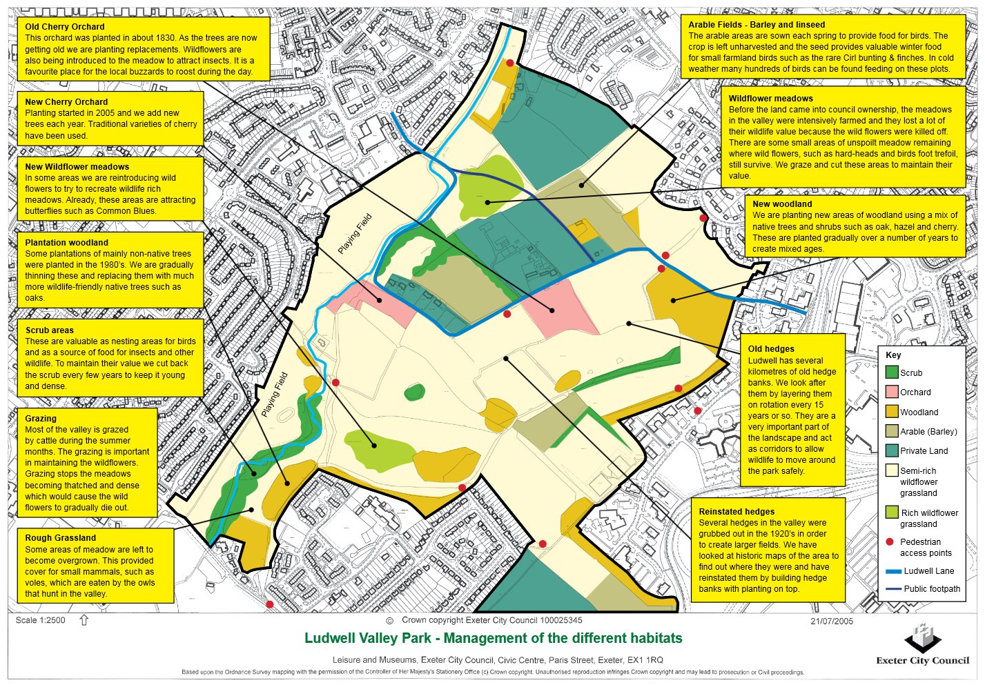 Figure 1) The current environments found within Ludwell Valley Park
The impressive slopes and hill looking over Exeter are a direct result of the geology of the area. The higher parts of Ludwell Valley are located on the deposits of Heavitree Breccia, whereas the lower areas of Wonford Playing Fields are situated on the Alphington Breccia. Breccia is a term used in geology for a sedimentary rock comprised of angular fragments of rock (over 2mm in diameter) that are cemented together by a matrix. This matrix can either be comprised of the same or different types of components to that of the larger fragments. Breccia is very similar to conglomerates, such as Puddingstone. The main difference between the two is the shape of the particles. Breccia is made up of angular fragments, where as conglomerates are made up of rounded fragments, that have commonly been rounded by water action. Breccias can have different properties to each other, for example their resistance to weathering can and do vary. This is the case at Ludwell Valley. The Heavitree Breccia is better cemented that the Alphington Breccia, which makes it more resistance to weathering and have resulted in the sharp slopes visible today. This geological layout has helped to create a spectacular example of an asymentric river valley for the Northbrook.
Heavitree Breccia was extensively used within Exeter as a building material, and as such many building and wall are are made from this stone. It was mainly selected because it was a readily available, pretty resistant, material that could be sourced locally. There are still many buildings and walls that are constructed out of Heavitree Breccia visible today, particularly in the area of the city around Heavitree. Many of these can easily be identified thanks to their high levels of weathering and red colour, Figure 3.
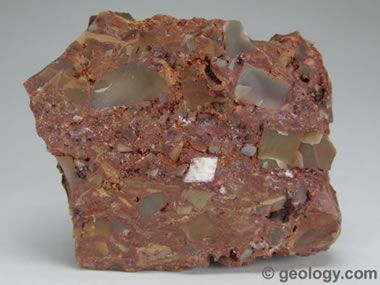 Figure 2) An example of a Breccia comprising of Chert fragments
 Figure 3) A wall and building constructed out of Heavitree Breccia showing extensive weathering to form rounded blocks
Due to the creation of this steep sided asymetic valley as a result of the geology, Ludwell Valley also contains two steep headed dry river valleys. These run from the top of the hill down into the valley area, perpendicular to the Northbrook below. Ludwell Lane follows the larger of the valleys, but effectively masks it. The second valley is found at the posted coordinates and is much clearer to see. Both valleys start at the top of the Heavitree Breccia outcrop and run down to the Alphington Breccia Northbrook Valley bottom. The reference point indicates both the bottom of the valley and the beginning of the Alphington Breccia. The valleys are thought to be Pleistocene in age. During the Quaterary period (the last c. 2 million years), which covers the Pleistocene, periglacial conditions prevailed within southern England. This is important because unlike glacial periods, periglacial periods go through much more seasonal changes, with the top layer (termed the active layer) freezing during the winter and then thawing during the relatively short summers. During the periglacial periods the ground below the active layer would remain frozen and as such the water, and waterlogged desposits, would flow over this still frozon ground (this process is called solifluction). This resulted in two main processes of erosion. The first was the waterlogged deposits, made up of some of the active layer, would creep down the slope, and the debris filling the water would give it a much higher erosion potential. As with many forms of erosion the locations of these valleys are created along faults and flaws within the Heavitree Breccia. This created many of the dramatic dry river valleys found in England, refered to as Coombes, including those visible at Ludwell Valley Park.
The valleys visible at Ludwell Valley park were therefore not created through riverine, or water erosion processes. Evidence for this comes from the shapes of the valleys. Valleys that are formed by riverine erosion, especially in the upper reaches close to the source, tend to have a V shaped cross section and very steep sides. The erosion is not only caused by the water itself but also by the rocks and stones that the river carries. Valleys created by glacial or periglacial processes tend to have a more U shaped cross section. This is because unlike the riverine erosion, which is eroded in a narrow area, glacial and periglacial processes tend to erode over a wider area, often all the way across the valley.
In Ludwell Valley Park after the valleys were created they would have contained water whenever the rain was sufficiently heavy enough to wash down the slopes. However, because of their topographic location none of the dry valleys within Ludwell Valley park contain a watercourse.
To log this EarthCache please with email me or message me through my profile the answers to these following questions
Go to the posted coordinates
1) Look at the slope in front of you. Estimate the steepness of the top section in degrees from horizontal.
2) What cross sectional shape does the valley have?
3) Based on your observation of the valleys shape what processes do you think created it?
4) Using the reference point how long is the valley?
5) The reference point is 18m above sea level. Take a height reading from the posted coordinates and indicate the difference in height.
6) Based on the geology of Ludwell Valley park why do you think this height difference exists?