Park at the posted coordinates, but only when it is safe to turn. Not RV friendly.
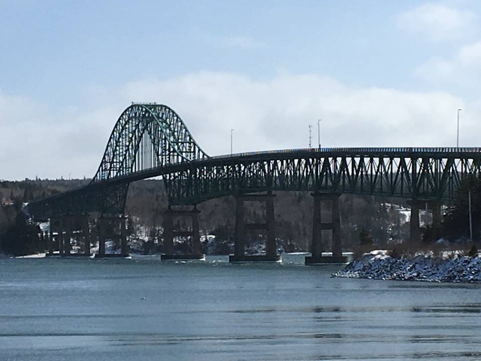
This earthcache brings you to Seal Island, which lends its name to the grand bridge spanning the 35 km-long Great Bras d’Or Channel. The channel connects the Atlantic Ocean (Sydney Bight) to Bras d’Or Lake.

The prominent body of water that dominates the interior of Cape Breton Island is known alternately as the Bras d’Or Lakes, the Bras d’Or Lakes system, or simply, Bras d’Or Lake (its official Canadian geographic name; the Indigenous Mi’kmaq people call(ed) the lake Pitu’pok, meaning “long salt water”). Strictly speaking, these Canadian names are all misnomers – the “lake” is in fact an estuary – but for simplicity I will still refer to it as a lake.
An estuary is a semi-enclosed coastal body of water having a free connection to the open ocean, within which seawater interacts with fresh water derived from land drainage. Bras d’Or Lake fits this description, as the water in the lake is approximately one-third fresh and two-thirds saline (i.e. “brackish”), though these proportions differ throughout the lake. This estuarine ecosystem has been designated a UNESCO Biosphere Reserve because of its unique biodiversity.

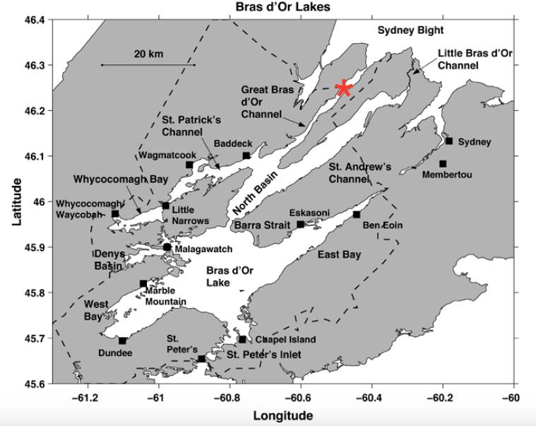
As the map shows, Bras d’Or Lake can be divided into northern and southern basins, connected by the kilometre-wide Barra Strait. The south basin consists of East and West Bays, Denys Basin, and St. Peter’s Inlet; the north basin is more elongated, with Great Bras d’Or, St. Andrew’s, and St. Patrick’s Channels leading to Whycocomagh Bay and Little Bras d’Or Channel. Great Bras d’Or is believed to have formed some 25 million years ago, as rivers eroded away a seam of Windsor Group rocks, leaving more resistant crystalline hills towering above the channel on either side.
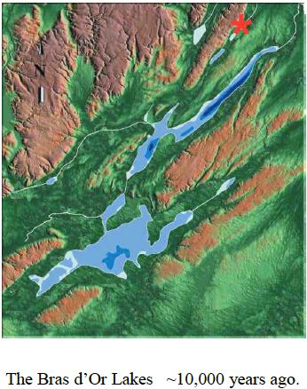
Bras d’Or Lake was not always the brackish estuary it is today. It has undergone significant ecological and hydrological evolution as global sea levels have risen and fallen over millions of years. During the last ice age, some 10,000 years ago, so much water was locked up as snow and ice in glaciers that global sea levels were approximately 50 m lower than they are today. Back then, the Bras d’Or Lakes were true distinct lakes – separated from the ocean and connected to each other by rivers – the shores of which can be identified today using sonar. (The illustration below shows the approximate former size of the lakes; the dark green area roughly denotes the lake's present-day shoreline.) As the planet warmed and glaciers melted, sea levels rose. Some 6,400 years ago, the ocean had risen about 25 m, high enough to breach what is now Great Bras d’Or and inundate the ancient lakes, filling the basin to its present size. Little Bras d’Or, which had formerly been a river draining the lake system, became a sinuous “strait” connecting the brackish lake to the ocean in a second location.

Sea level in Sydney Bight (the open ocean at the end of Great Bras d’Or) fluctuates by about 37 cm between high and low tides, while in the lake the tide only varies by 3-4 cm. Great Bras d’Or is too narrow and shallow to allow very much water from Sydney Bight to enter the lake at high tide before it starts dropping again. The tidal fluctuation at the channel’s entrance is 16 cm, decreasing to 7.3 cm at the Seal Island Bridge (ground zero). During prolonged periods of low atmospheric pressure, Sydney Bight may remain at high tide much longer, allowing more water to enter the lake and raising lake levels by amounts that far exceed what can be attributed to the sun and moon alone. At the extreme south end of the lake, the 800 m-long St. Peters Canal connects the lake to the oceanic St. Peters Bay. Due to the different tidal conditions on the respective lake and ocean sides of that isthmus, the St. Peters Canal is the only canal in the world that must account for either side being higher or lower than the other.
Sea level has been rising since the end of the last ice age, known as the Wisconsinan glaciation. This is due to a combination of melting glaciers adding great volumes of water to the ocean, and previously glaciated ocean floor slowly rebounding in the absence of that tremendous weight. The rate of sea level rise was about 79 cm per century when Sydney Bight inundated the Bras d’Or Lakes, and is about 37 cm per century today. As a result of climate change, the rate of sea level rise is forecast to increase to about 60 cm per century by the year 2030, 99 cm per century by 2080, and 115 cm per century by 2100. As of this writing, the anticipated rise around Cape Breton is about 76 cm total over the next 100 years.
Sources
- Lambert, T. 2006. Sea Level Rise and the Bras d’Or Lakes. The Blue Heron.
- Petrie, B. and Raymond, J. 2002. The Oceanography of the Bras d’Or Lakes: General Introduction. Proceedings of the Nova Scotia Institute of Science. Vol. 42, p. 1, pp. 1-8.
- Shaw, J., Piper, D., and Taylor, R. 2002. The Geology of the Bras d’Or Lakes, Nova Scotia. Proceedings of the Nova Scotia Institute of Science. Vol. 42, p. 1, pp. 127-147.
- https://en.wikipedia.org/wiki/Bras_d’Or_Lake
- https://en.wikipedia.org/wiki/St._Peters_Canal
- http://brasdorpreservation.ca/bras-dor-lakes/
- http://www.unesco.org/new/en/natural-sciences/environment/ecological-sciences/biosphere-reserves/europe-north-america/canada/bras-dor-lake/
-------------------------------------------------
To log this earthcache as found, first e-mail me the answers to the first three questions (don’t post them in your log!). You may log it as found without hearing a response from me, but e-mails with missing or poor answers may be deleted, and the cacher notified as to the reason(s) why.
Questions
1. How high would the tide have to rise for your feet to get wet at the posted coordinates? How might your great-great-grandchildren answer this question in 100 years?
2. Which side of the Great Bras d’Or Channel boasts taller hills?
3. Walk over to waypoint 2. Which way is water flowing under the bridge? Does this suggest Sydney Bight is at high or low tide?
4. (Optional) Post a picture of yourself and your GPSr with the Seal Island Bridge in the background.
| I have earned GSA's highest level: |
 |
FTF: MineRP