NOTE: This geocache is only available certain times of the day. During most of the year, this is from Monday to Friday from 10 am to 9 pm; on Saturday from 10 am to 5 pm; and on Sunday from 1 pm to 5 pm.
This geocache is generally NOT available on statutory holidays, and Sundays in July and August. Check here for up to date information.
Memorial Peace Park
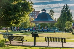
Memorial Peace Park is located in downtown Maple Ridge on 224th Street between Lougheed Highway and Dewdney Trunk Road.
It was developed to be a true community gathering place, and is surrounded by Maple Ridge City Hall, the Leisure Centre, the Maple Ridge Public Library, The ACT Arts Centre and Haney Place Mall.
On any given day you can find people enjoying time the park's fountains, the bandstand, public art, and its gardens and open green space.
Go to the posted coordinates, then make your way through the different stages and collect the clues from various places in Memorial Peace Park.
Find the code in this format:
ABC.D EFG
The stages are in easy walking distance from one another, and numbered from 2 to 4. When you have gathered all the clues, make your way to the Final Location where you enter the building, and make a search for the code you have just uncovered, to find the geocache.
Stage 2 - Cenotaph (Virtual Stage) N 49° 13.163 W 122° 36.067
D = What year was the cenotaph moved to 8th St? Use the last digit.
F = What name is inscribed on the stone with the year 1916? Use the first letter
Stage 3 - Secondary Schools (Virtual Stage) N 49° 13.163 W 122° 36.033
A = What is the year of the first high school referendum? Use the last digit.
B = What was the name of the street now called 224th Street> Use digit.
Stage 4 - Agriculture and Learning (Virtual Stage) N 49° 13.158 W 122° 35.975.
Use both information boards here!
G = What's the name of the hall built in 1909? Use the first letter.
C = What year was the Haney Central School torn down> Use the last digit.
E = What's the name of the school that stood at 232nd and Dewdney? Use the second letter.
Final Location N 49° 13.199 W 122° 35.993
You're almost there, but enter here during opening hours only!
You will likely not receive GPS signals inside, so use the code you found (ABC.D EFG) to find the geocache inside, a short distance away. There is no need to go upstairs.