EDUCATIONAL LOGGING REQUIREMENTS
In order to substantiate your visit and comply with the educational requirement for Earth Caches you have to submit your answers to the following questions to the cache developers via their profile:
For purposes of logging this cache you must answer the following two questions.
1) Immediately to the North of the GZ is a land form. What land form is this? Explain how you arrived at this conclusion.
2) Estimate the width of the flat top of the land form.
|
A plateau, also called a high plain or tableland, is an area of highland, usually consisting of relatively flat terrain that is raised significantly above the surrounding area, often with one or more sides with steep slopes.
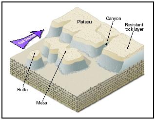
A mesa (pronounced MAY-sa) is an isolated, flat-topped hill or mountain with steep sides that is smaller in area than a plateau.
A butte (pronounced byoot) is also a flat-topped hill with steep sides, though smaller in area than a mesa.
Definitions of the surface areas of mesas and buttes vary. Some define a mesa as having a surface area of less than 10 square kilometers, while a butte has a surface area less than 1 000 square meters. Another definition is that the surface area of a mesa is larger than 2.59 square kilometers and the surface area of a butte is smaller than that. Then there is a more simple definition that defines a mesa as a landform that is wider than it is high and a butte as one that is higher than it is wide.
A mesa's and butte's characteristic shape—flat top and cliff like sides—is due to the layers of rock forming them. The top layer of a mesa and a butte is a hardened layer of rock that is resistant to erosion. Sometimes this top layer, called the cap rock, is not sedimentary rock but is cooled and hardened lava that had spread out across the landscape in repeated flows from fissures or cracks in the ground. Beneath this flat protective cap of rock are horizontal layers of softer sedimentary rock. To varying degrees, these layers are not as resistant to erosion.
Mesas maintain their shape because their cap rock offers protection to the layers of softer rock beneath. That protection is short-lived. Water from storms washes over the sides of the mesa, wearing them away. As the sides retreat inward, the overhanging sections of cap rock weaken, fracture, and fall.
As the process of erosion continues, a mesa shrinks in size. Over time, it becomes a butte, taller than it is wide. Unrelenting, water erodes the butte as it had the mesa before it and the plateau before that. Capped by its resistant rock but ever shrinking, the butte may eventually erode into a pinnacle. This tall, slender tower or spire of rock will stand until it, too, succumbs to erosion and eventually crumbles to the valley floor.
References
Gavin Whitfield. 50 Must-See Geological sites in South Africa.
Wikipedia
Science Clarified