[PT]
O VG (vértice geodésico) do Vale do Ladrão encontra-se a 575 metro de altitude, sendo o único VG na freguesia do Paul não-limítrofe.
A atravessar a zona de acesso ao VG situa-se a componente sul do trilho da Piçarra, 1 de 4 trilhos presentes no território do Paul sendo que 3 deles são PT’s.
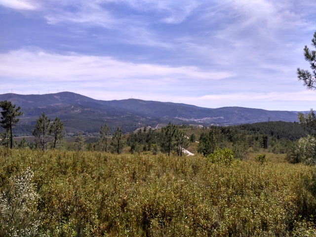
Na paisagem do topo do VG podem apreciar a vista sobre a Serra da Gardunha e as localidades de Lavacolhos e Silvares, caso queiram dar um mergulho é so descer a encosta, do lado oeste para a Ribeira do Paul, ou para o lado este para o Rio Zêzere.
A cache irmã localiza-se no VG da Piçarra a 2700 metro de distancia: GC77DMB.
Vértices Geodésicos:
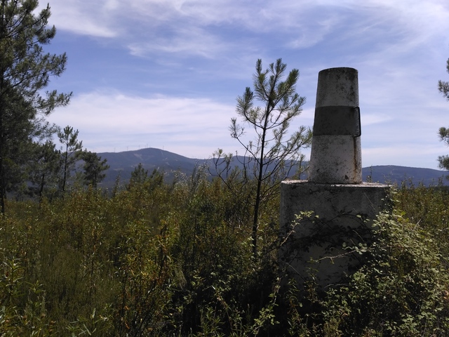
Conjunto de todos os vértices geodésicos e das suas relações geométricas, distribuídos pelo país, colocado sem posições dominantes de forma a garantir intervisibilidade, devidamente coordenados. Estão materializados através de diversas formas geométricas, como pirâmides ou troncos de cone sobre cilindros (bolembreanas) ou são coincidentes com estruturas já existentes.
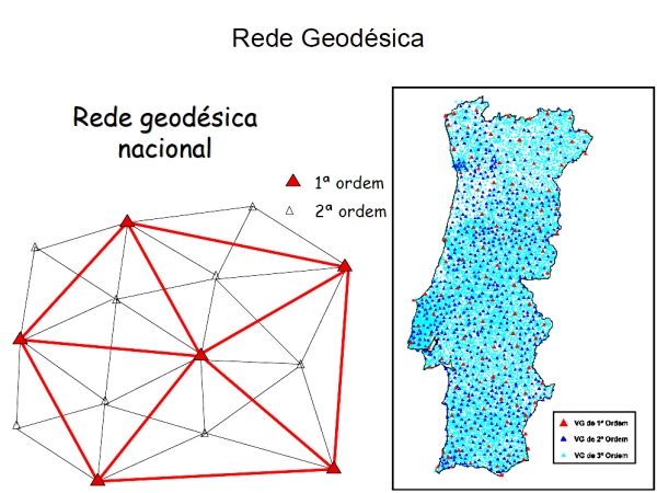
Um VG ou vértice geodésico (popularmente chamado "talefe" e/ou "Pinoco" no Norte e Centro de Portugal) é um sinal que indica uma posição cartográfica exacta e que forma parte de uma rede de triângulos com outros vértices geodésicos. São escolhidos sítios altos e isolados com linha de visão para outros vértices.
A rede geodésica portuguesa é formada por vértices geodésicos que se dividem em três ordens de importância:
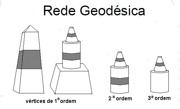
1ª Ordem - pirâmides distando 30 a 60 km
2ª Ordem - cilindro + cone listados distando 20 a 30 km
3ª Ordem - cilindro + cone distando 5 a 10 km
O número de vértices existentes na totalidade do território (Portugal Continental e Regiões Autónomas) é, atualmente, de cerca de nove mil, repartidos por vértices de: Continente: 1ª Ordem (cerca de 120), 2ª Ordem (cerca de 900) e 3ª Ordem (com uma densidade aproximada de 1 vértice por cada 10 km²) Arquipélago dos Açores: cerca de 500 Arquipélago da Madeira: cerca de 150 A RGN é a infraestrutura básica onde se apoia toda a cartografia do País, e que serve todos aqueles (empresas, autarquias e outros organismos públicos e privados) que, por força das suas atividades, necessitam de referenciar geograficamente os seus projetos (os Planos Diretores Municipais, por exemplo).
O Centro Geodésico de Portugal, está situado na Serra da Melriça, freguesia e concelho de Vila de Rei, distrito de Castelo Branco.
Encontrando-se a uma Altitude máxima ao Nível do Mar de 592m (anm/asl) é delineado fundamentalmente pelo Marco Geodésico padrão, pelo Museu da Geodesia e áreas envolvente de apoio e estacionamento.
O Marco Geodésico, é conhecido popularmente por "Picoto da Melriça", sendo constituído por um vértice geodésico de 1ª ordem, piramidal, em alvenaria com 3 metros de base e 9 metros de altura e está desde á muito associado à história da cartografia moderna em Portugal. Esta iniciou-se no século XVIII, no reinado de D. Maria I, quando a soberana convidou a Academia Real da Marinha, a iniciar os trabalhos de triangulação geral do território, para a realização da Carta Geográfica do Reino.
A importância do Marco Geodésico padrão, resulta de que foi a partir deste ponto, que se deu início à marcação dos restantes 8.000 vértices geodésicos de Portugal Continental.
Fontes:
Alguns sites uteis e de relevante interesse onde se pode obter informação sobre Marcos/Vértices Geodésicos:
http://pt.wikipedia.org/wiki/V%C3%A9rtice_geod%C3%A9sico
http://pt.wikipedia.org/wiki/Geod%C3%A9sia
http://pt.wikipedia.org/wiki/Triangula%C3%A7%C3%A3o_geod%C3%A9sica
http://www.fc.up.pt/pessoas/jagoncal/coordenadas/paper_cncg2009.pdf
[EN]
The GV (geodesic vertex) of the “Thief Valley” is at 575 meters in altitude, being the only GC non-bordering in Paul.
Crossing the access zone to the GV is the southern part of the Piçarra trail, 1 of 4 trails present in Paul's territory, 3 of which are PT's.
In the landscape of the top of the GV you can enjoy the view over the Serra da Gardunha and the localities of Lavacolhos and Silvares, if you want to take a swim you just need to go down the slope, from the west side to the Ribeira do Paul, or to the east side to the Rio Zêzere.
The sister cache is located at GV of Piçarra at 2700 meters away: GC77DMB.
Geodetic Vertices:
Set of all geodesic vertices and their geometric relations, distributed throughout the country, placed without dominant positions in order to guarantee intervisibility, duly coordinated. They are materialized through various geometric shapes, such as pyramids or cone trunks on cylinders (Bolembreans) or are coincident with existing structures.
A VG or geodetic vertex (popularly called "talefe" and / or "Pinoco" in the North and Center of Portugal) is a sign that indicates an exact cartographic position and that forms part of a network of triangles with other geodesic vertices. High and isolated sites with line of sight are chosen for other vertices.
The Portuguese geodetic network is formed by geodesic vertices that are divided into three orders of importance:
1st Order - pyramids distant 30 to 60 km
2nd Order - cylinder + cone listed 20 to 30 km distant
3rd Order - cylinder + cone distant 5 to 10 km
The number of vertices in the whole territory (Continental Portugal and Autonomous Regions) is currently around 9 thousand, divided by vertices of: Continent: 1st Order (about 120), 2nd Order (about 900) and 3rd The archipelago of the Azores: about 500 Madeira Archipelago: about 150 The RGN is the basic infrastructure where all the cartography of the Country is supported, and that serves all those (companies with a minimum of 1 vertex per 10 km²). , Municipalities and other public and private organizations) that, due to their activities, need to geographically refer their projects (the Municipal Master Plans, for example).
The Geodesic Center of Portugal, is situated in the Serra da Melriça, town and county of Vila de Rei, district of Castelo Branco.
Finding a maximum Sea Level Altitude of 592m (amm / asl) is outlined fundamentally by the standard Geodetic Frame, the Museum of Geodesy and surrounding support and parking areas.
The Geodesic Landmark, is popularly known as "Picoto da Melriça", consisting of a geodesic vertex of the first order, pyramidal, in masonry with 3 meters of base and 9 meters of height and has since been very associated with the history of modern cartography in Portugal. It began in the eighteenth century in the reign of D. Maria I, when the queen invited the Royal Academy of the Navy to begin the general triangulation of the territory for the realization of the Geographical Chart of the Kingdom.
The importance of the standard Geodetic Framework results from the fact that it was from this point that the marking of the remaining 8,000 geodesic vertices of Continental Portugal began.
Sources:
Some useful sites of interest where you can gather information about Geodetic Mark / Vertices: (In portuguese)
http://pt.wikipedia.org/wiki/V%C3%A9rtice_geod%C3%A9sico
http://pt.wikipedia.org/wiki/Geod%C3%A9sia
http://pt.wikipedia.org/wiki/Triangula%C3%A7%C3%A3o_geod%C3%A9sica
http://www.fc.up.pt/pessoas/jagoncal/coordenadas/paper_cncg2009.pdf