このアースキャッシュでは、有珠山の噴火の歴史について学びます。
有珠山は、北海道は洞爺湖の南に位置する標高737mの活火山です。
有珠山が形成されたのは約2万年前と考えられており、噴火を繰り返して成層火山をなしましたが、約7千年前に山頂部が爆発しました。その際に山体崩壊が発生して南側に口を開けた陥没地形が形成され、この時発生した岩なだれは海にまで達し、有珠湾周辺の複雑な海岸線をつくりました。
山体崩壊後は長く活動を休止していましたが、1663年を境に突如として噴火活動を再開し、現在に至るまで繰り返し噴火を繰り返しています。
年表を以下に示します。
1663年:山頂カルデラよりプリニー式の噴火があり、さらに噴出物によって、山体崩壊により形成されていた山頂南側開口部が再び閉塞され、山頂火口は現在のような臼状の地形となりました。
1769年:山頂陥没部に現在の小有珠にあたる溶岩ドームが形成されたのは、1663年の噴火かこの噴火の時と考えられています。
1822年:有珠山の噴火史上で最大の50人以上の人的被害をもたらした噴火です。後述の銀沼は、この噴火時の火口に水がたまったものされています。
1853年:この噴火後に山頂に溶岩ドームが成長しはじめて、大有珠となりました。
上記の江戸時代の噴火はいずれも山頂からのもので、多量の噴出物を一気に放出する、いわゆるプリニー式噴火でした。
1910年:この噴火は、マグマが洞爺湖付近の地下水と遭遇して発生した水蒸気爆発です。また、この噴火活動により、火口に近い洞爺湖岸では温泉が湧出するようになり、これが洞爺湖温泉の始まりとなっています。
1944-1945年:有珠山東麓で発生した水蒸気爆発で、17回にも及ぶ噴火がありました。噴火活動収束後に、粘度の高い溶岩が押し出されて溶岩ドームが形成され、昭和新山となりました。昭和新山は、かつて畑があったところに形成されたため、溶岩ドームの表面には、砂や泥が溶岩の熱で焼かれて出来た天然レンガが張り付いています。
1977-1978年:1977年8月7日午前9時12分に山頂カルデラ、小有珠斜面からのプリニー式噴火が始まり、8月14日、未明まで4回の大きな噴火を含む16回の噴火が断続しました。11月16日、水蒸気爆発が発生し始めて翌年の10月27日まで続きました。1978年6月15日には、カルデラ内の池であった銀沼が、付近に出来た火口による噴火で消滅し、その後、9月12日夜の一連の水蒸気爆発では最大レベルのマグマ水蒸気爆発により、巨大な銀沼大火口へと姿を変えました。
2000年:3月27日からの火山性地震の分析や断層の探索により近日中の噴火が予知され、3月29日には気象庁から緊急火山情報が出されました。噴火直前に北海道大学有珠火山観測所が144時間以内に噴火すると予告し、その予告から143時間目に噴火しました。
3月31日午後1時7分、西山山麓からマグマ水蒸気爆発が発生しました。噴煙は火口上空3,500mに達し、周辺に噴石が放出され、北東側に降灰しました。翌日には西山西麓や金比羅山でも新火口が開き、付近に次々と新しい火口を形成しました。火口に近い地域では噴石や地殻変動による家屋の破壊が多発しましたが、同年8月になると深部からのマグマ供給が停止し、9月以降は空振や火山灰噴出の活動は衰えました。
[タスク]
以下のクイズへの回答をキャッシュオーナーに送ってください。
クイズ 1:銀沼火口の観察
このアースキャッシュのGZ(公開座標)付近からは、銀沼火口を観察することができます。銀沼火口は、1978年7-10月の噴火により形成されました。この時、 噴火が頻繁に繰り返されて、上空から降下した噴石や火山礫、火山灰、地表を流れ下った火砕サージが堆積しました。銀沼火口を観察すると、さまざまな火山性堆積物が繰り返し堆積した証拠が見つかります。それは何でしょうか?(柵を超えないでください)
クイズ 2:昭和新山の観察
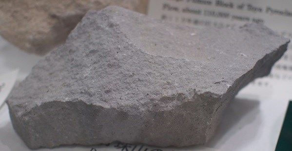
昭和新山の溶岩ドームを形成する岩石はデイサイト質の溶岩で、下写真のような色をしています。Additional Waypoint, " Mt. Showa Shinzan"から観察できる昭和新山の色は、この岩石の色と同じでしょうか?異なる場合は、何故異なる色をしているのでしょうか?
[English]
With this earthcache, you will learn the history of eruptions of Mt. Usu.
Mt. Usu is an active volcano with an altitude of 737 m, located in the south of Lake Toya in Hokkaido.
Mt. Usu was formed about 20 thousand years ago and it formed a stratovolcano by repeated eruptions, but the summit of the mountain exploded about 7 thousand years ago. At that time, the collapse of the mountainous body occurred to form a caved landform that opened the mouth to the south, and the rocks that formed at this time reached the sea, creating a complex coastline around the Usu Bay.
Although the activity was paused for a long time after the collapse of the mountainous body, the eruption activity resumed suddenly in 1663 and erupted repeatedly until now.
The chronology of the eruptions is shown below.
1663: There was a plinian type eruption from the summit caldera, and furthermore, by the ejecta, the southern side opening at the mountain summit formed by the collapse of the mountain was closed again, and the summit crater became a mortar-shaped topography like present.
1769: It is thought that the eruption of 1663 or the eruption of this time formed the lava dome, which corresponds to the current Syo-Usu, in the depressed part of the mountain.
1822: This eruption caused the damage of 50 people or more, the largest damage in the eruption history of Mt. Usu. Ginnuma (silver marsh) described later is that water accumulated in the crater at the time of the eruption.
1853: Lava dome began to grow on the summit after this eruption, it became the current O-Usu.
Eruptions in the above Edo era were all from the summit and were so-called Prinny eruptions that released a large amount of ejecta at once.
1910: This eruption was a steam explosion that occurred when magma encountered groundwater near Lake Toya. Also, due to this eruption activity, hot springs began to spring out on Lake Toya shore near the crater, which is the beginning of Lake Toyako hot springs.
1944-1945: A steam explosion occurred at the east foot of Usu Mountain, with 17 times of eruptions. After convergence of the eruption activity, high viscosity lava was pushed out to form a lava dome and became Mt. Showa Shinzan ("shinzan" means "new mountain"). Since Mt. Showa Shinzan was formed in the place where the field had existed, natural brick made by burning sand and mud with the heat of the lava is stuck on the surface of the lava dome of Mt. Showa Shinzan.
1977 - 1978: At 9:12 am on August 7th, 1977, a plinian eruption started from the small Usu caldera, which was the mountain peak caldera. Until the early August 14th, 16 times of eruptions, including 4 big eruptions, continued intermittently. On November 16th, the steam explosion began to occur until October 27th, 1978. On June 15th, 1978, Ginnuma ("silver swamp") which was a pond in the caldera disappeared by the eruptions from the craters made in the vicinity, then in the series of steam explosions on the evening of September 12, Ginnuma changed into a huge Ginnuma crater.
2000: According to the analyses of volcanic earthquakes from March 27th and the exploration of faults, eruptions in the near future was predicted, and emergency volcano information was issued from the Japan Meteorological Agency on March 29th. Just before the eruption, the Usu volcano observatory at Hokkaido University noticed that Mt. Usu would erupt within 144 hours, and actually Mt. Usu erupted at 143 hours from the notice.
A magmatic steam explosion occurred from the foot of Mt. Nishiyama at 1:07 pm on March 31st. The plume reached 3,500 m over the crater, the boulders were discharged to the surroundings, and volcanic ash fell to the northeast side. On the next day, new craters were opened one after another in Mt. Nishiyama west foot and Mt. Kanpira. In August of the same year the magma supply from the deep was stopped, and since the September the volcanic activity declined.
[Task]
Send to the cache owner your answers to the quizzes below.
Quiz 1: Observation of Ginnuma crater
From the vicinity of GZ (the published coordinates) of this earth cache, you can observe Ginnuma crater. The Ginnuma crater was formed by the eruption of July - October, 1978. At this time, the eruptions were repeated frequently, deposits that fell from the sky, like, volcanic gravel, volcanic ash, and pyroclastic surges flowing down the surface accumulated. Observing the Ginnuma crater, you can find an evidence that various volcanic sediments were repeatedly deposited. What is the evidence? (Please do not exceed the fence)
Quiz 2: Observation of Mt. Showa Shinzan
The rock forming the lava dome of Showa Shinzan is a dacite lava and has a color like the picture below. Please compare the colors of Mt. Showa Shinzan observed from Additional Waypoint, "Mt. Showa Shinzan" and the rock in the picture below. Are the colors the same or not? If they are different, why are they in different colors?