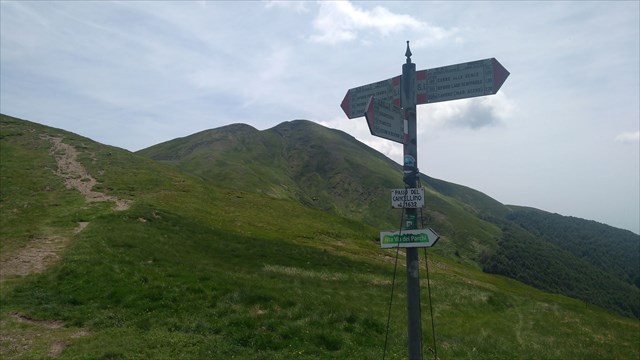
Situato ad un'altitudine di 1632 metri sul livello del mare, il Passo del Cancellino si trova sullo spartiacque appenninico, a metà strada tra il Corno alle Scale ed il Monte Gennaio; divide le valli del Silla a nord (comune di Lizzano in Belvedere - BO) e del Verdiana a sud (comune di San marcello Piteglio - PT). Il nome deriva dalla presenza di un antico cancello che dava accesso ai pascoli cintati del Granduca di Toscana; la presenza di svariate pietre miliari ci ricorda che qui passava il confine con lo Stato Pontificio. La sella erbosa è un importante crocevia di sentieri: è infatti percorso dal sentiero di crinale 00, che qui coincide con la Grande Escursione Appenninica, dal sentiero 20 per il Passo dei Malandrini e il Rifugio del Montanaro, e dal sentiero 121 per il Rifugio Segavecchia e Lizzano in Belvedere. Oltre alla GEA, qui passa l'Alta Via dei Parchi. Come accade in molti punti del crinale, si nota in modo evidente la differenza dei cartelli posti dalle differenti sezioni del CAI. Il passo è spesso battuto da forti venti, sono state misurate raffiche a 224 km/h.
La cache è un piccolo contenitore di tipo lock and lock nascosto sotto alcune pietre. Contiene logbook, matita, e piccoli oggetti da scambiare. Buona ricerca!
Located at an altitude of 1632 meters above sea level, Cancellino Pass lies on the Apennine waterside, halfway between Corno alle Scale and Mount Gennaio; it divides the valleys of the Silla to the north (Lizzano in Belvedere - BO) and Verdiana to the south (municipality of San marcello Piteglio - PT). The name (meaning "Small Gate") derives from the presence of an ancient gate that gave access to the grazing pastures of the Grand Duke of Tuscany; the presence of several milestones reminds us that here was the border with the Pontifical State. The grassy saddle is an important crossroads of paths: it is in fact traversed by the ridge trail 00, which here coincides with the Great Appennine Hiking (GEA), by trail 20 to the Passo dei Malandrini and the Rifugio del Montanaro, and by trail 121 to the Rifugio Segavecchia and Lizzano in Belvedere. In addition to the GEA, here is the Alta Via dei Parchi. As is the case in many points of the ridge, the difference between the signs of the various sections of the CAI is evident. The pass is often beaten by strong winds, gusts have been measured at 224 km / h.
Cache is a small lock-and-lock container hidden under some stones. It contains logbooks, pencils, and small items to swap. Happy geocaching!