Fish Hoek Beach #1.7: Overview

This is the 8th iteration of this cache which has had a long history of being moved or replaced! It is a small flip-topped, camo-taped tablet pot which is hidden at a location overlooking this small park which gives a fine overview of the beach from its southern end. Please watch out for various types of muggles, who tend to hang out in the park, as you undertake your caching activities
To reach the cache: either . . .
a) walk along Jager's Walk from its start at the southern end of Fish Hoek beach exit at the nearest pedestrian access tunnel under the railway and make your way up to the cache location.
b) park roadside above the park a few metres west of the steps.
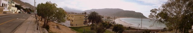
Fish Hoek beach is 'one of the most beautiful in the world' with a gentle curving reach from the (no longer used) Clovelly Station to the north past the mouth of the Silvermine River (and adjacent wetlands) to the little lighthouse mid-way which represents the start of the developed shoreline with beach wall and promenade/walkway. The walkway stretches all the way to Sunny Cove Station at the southern edge. Dog walking is allowed from Clovelly to the start of the walkway but prohibited from here to Sunny Cove.
Fish Hoek Bay is protected from the currents and stronger surf in the rest of False Bay and the 1.5km sandy beach is quite flat. Swimming is allowed along the entire beach with lifesavers on duty during the summer peak season, and body surfing, boogie boarding, wind surfing and kayaking are popular water activities.
The water is far warmer than along the Atlantic Seaboard on the other side of the Peninsula, averaging between just under 17°C annually (similar to Northern Mediterranean Waters like Monte Carlo or Nice, and peaking at 24°C in summer months.
Restaurants and children's play areas are situated at the more popular southern end where also Jager Walk, a scenic path with numerous concrete benches (known locally as the Cat Walk) runs past rock pools.

At the northern end, the Silvermine River drains from the Silvermine mountains, through the wetlands at Clovelly and (during wetter months) into the bay.
Shark spotters are always on duty throughout the daylight hours but despite this, there have been two fatal attacks on swimmers in the bay in recent years, one in November 2004 and one in January 2010. On September 28, 2011, a 44-year-old British man Michael Cohen lost part of his leg after being mauled by a Great White shark, despite repeated warnings, the beach being closed and shark flag flying.
The northern parts of the beach are less developed, and are used by trek fishermen to launch their boats and clean nets. Annual visits from Southern Right Whales occur from June to November.
See here for a great drone overview video of beach and here for a video of a Great White Shark cruising just off the beach.
See here for information on FHB tides, sun and moon rise and set, here for detailed 10-day weather forecasts (including wind and waves), here for interactive weather statistics.