Espero que este EarthCache te brinde un momento especial en el campo. Si esta experiencia te hizo sonreír, aprender algo nuevo o simplemente mejorar tu día, te invito a apoyarla:
-Deja un Punto Favorito, ayuda mucho a mantener este EarthCache visible.
-Vota para Geocache of the Week, tu voto es muy importante:
-Etiqueta a @earthcache en Instagram, me encanta ver sus aventuras.
-Visita el blog para más historias: geocaching.com.br
🇪🇸 Español
¿Cómo funciona un EarthCache?
Es muy sencillo: visita el lugar, lee atentamente la página del EarthCache, responde las preguntas al owner (no en el log) y luego registra tu visita.
Si tienes alguna duda, no dudes en ponerte en contacto.
Objetivo de este EarthCache
El objetivo de este EarthCache es analizar el relieve natural de esta región y comprender cómo los Incas aprovecharon las diferencias de altitud y temperatura para el cultivo de alimentos.
Perú y la Sierra Andina
Perú es un país con una enorme diversidad de ecosistemas, que incluyen desiertos, montañas de hasta 7.600 metros y la selva amazónica, que cubre cerca de la mitad del territorio.
Las principales regiones del país son La Costa, La Sierra y La Selva. Este EarthCache se encuentra en la Sierra Peruana.
 |
| Figure one |
Suelos, altitud y terrazas incas
Los suelos andinos son relativamente jóvenes y están sujetos a una intensa erosión debido a los fuertes gradientes del relieve. En función de la altitud, cambian la temperatura, la humedad, la radiación solar y el tipo de suelo, lo que da lugar a diferentes zonas altitudinales.
En los Andes se reconocen cinco zonas principales:
-
Tierra nevada
-
Tierra helada
-
Tierra fría
-
Tierra templada
-
Tierra caliente

Esta zonificación, propuesta por Alexander von Humboldt, explica cómo la temperatura disminuye con la altitud (en promedio menos de 0,6 °C por cada 100 m).
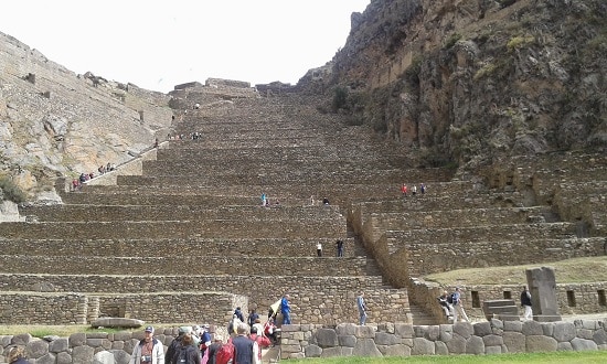
En Ollantaytambo, los Incas desarrollaron impresionantes terrazas agrícolas, capaces de crear distintos microclimas. Las terrazas inferiores son más cálidas, mientras que las superiores son más frías y húmedas. Esto permitió experimentar con cultivos, protegerlos de heladas y lluvias extremas, y aprovechar terrenos empinados y erosionables.
Además, en el waypoint 2 se encuentran los depósitos de Pinkuylluna, antiguos graneros ubicados estratégicamente para conservar alimentos gracias a la altitud y la ventilación natural.
 |
| Superior view |
 |
| Inferior view |
 |
| Pinkuylluna |
Preguntas
-
Según la figura 2, ¿en cuál de las cinco zonas andinas se encuentra este sitio?
-
¿Cuántas terrazas hay desde la parte superior hasta la inferior? ¿Esta diferencia de altitud implica una variación de temperatura?
-
Describe el suelo del lugar.
-
¿Por qué los Incas utilizaron terrazas para el cultivo de alimentos?
-
Una foto tuya en este increíble lugar será bienvenida (opcional). encontrados perto de lagos e lagoas.
🇬🇧 English
How does an EarthCache work?
It’s simple: visit the site, carefully read the EarthCache page, answer the questions to the owner (not in the log), and then log your visit.
If you have any questions, feel free to contact the owner.
Objective of this EarthCache
The objective of this EarthCache is to analyze the natural relief of the region and understand how the Incas used differences in altitude and temperature to cultivate their food.
Peru and the Andean Highlands
Peru is a country with a great diversity of ecosystems, ranging from deserts and high mountain peaks (up to 7,600 meters) to the Amazon rainforest, which covers nearly half of the country.
Its main regions are known as La Costa, La Sierra, and La Selva. This EarthCache is located in the Peruvian Sierra.
Soils, altitude and Inca terraces
Andean soils are relatively young and highly affected by erosion due to steep relief gradients. Variations in altitude strongly influence temperature, humidity, solar radiation and soil development, resulting in distinct altitudinal zones.
Five main altitude zones are recognized in the Andes:
-
Tierra nevada
-
Tierra helada
-
Tierra fría
-
Tierra templada
-
Tierra caliente
This altitudinal zoning, first proposed by Alexander von Humboldt, explains how temperature decreases with increasing altitude (on average less than 0.6 °C per 100 m).
At Ollantaytambo, the Incas built remarkable agricultural terraces that created multiple microclimates. Lower terraces are warmer, while higher ones are cooler and more humid. This system allowed crop experimentation, protection against frost and extreme weather, and cultivation on steep, erosion-prone slopes.
At waypoint 2, the Pinkuylluna storehouses can be found. These ancient granaries were strategically placed so that altitude and strong winds helped keep food fresh and preserved.
Questions
-
Based on figure 2, in which of the five Andean zones is this site located?
-
How many terraces are there from top to bottom? Does this altitude difference imply a temperature variation?
-
Describe the soil at this location.
-
What reasons led the Incas to use terraces to grow their food?
-
A photo of you at this amazing place would be very welcome (optional).