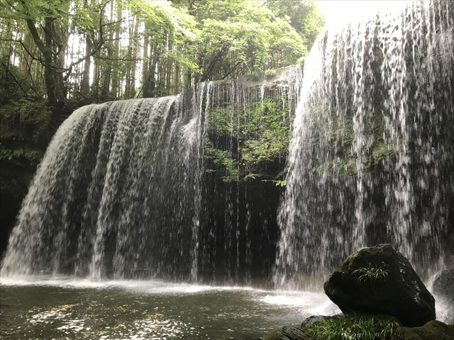
公開座標付近では、下の写真のような見事な滝をみることができます。
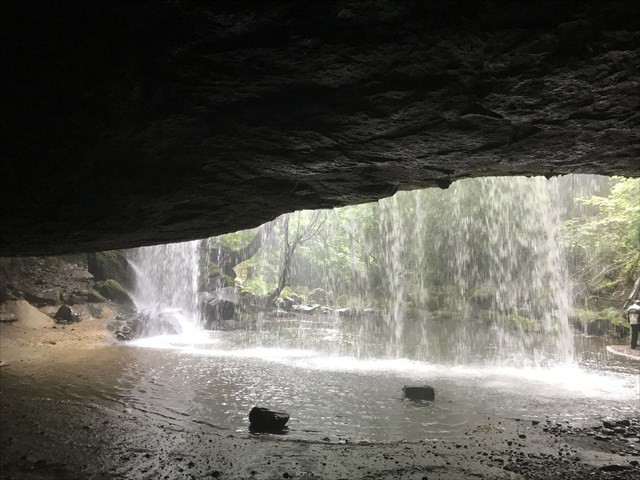
下の写真から分かるように、この滝の背後には空間があり、滝の流れを裏側から観察することができます。
この滝は、阿蘇山の噴火によって形成されました。その形成過程を以下に説明します。
1.阿蘇ではカルデラが形成される程の巨大な噴火が過去に4回発生しました。特に約9万年前の噴火は凄まじく、山口県や島原半島まで火砕流が到達しています。そのときの噴火では、火砕流がこのアースキャッスの公開座標に流れていた川を埋め立てました。

2.火砕流の堆積物は、それ自身の熱と圧力によって、固い岩である溶結凝灰岩となりました。この溶結凝灰岩が、現在の滝上部の岩です。 
3.溶結凝灰岩の上を流れる水が長い年月をかけて、かつての川が堆積した下の軟らかい層を浸食しました。一方、下の軟らかい層に比べて固い溶結凝灰岩の層は浸食されにくいために残りました。そのため、滝の背後に大きな空間が存在する現在のような構造になりました。 
[タスク]
以下のクイズの回答をキャッシュオーナーに送ってください。
[Quiz 1]:滝の上部の層(前に張り出している層)と下部の層(奥に凹んだ層)を観察して、それらの層の違いを説明してください。
[Quiz 2]:滝の下部の層を観察し、この層がかつてここを流れていた川が堆積した層である証拠を見つけてください。その証拠は何ですか?
[Quiz 3]:Quiz 2の回答の証拠をさらに詳しく観察して、公開座標付近はその川の上流、中流及び下流のどの辺りであったと考えられるかを答えてください。(ヒント:証拠の物の形状(角ばってる?丸い?)や大きさと、それらが川の上流から下流へとどのように変化するかを考えて見ましょう。小学校の理科で習いましたね!)
[English descriptions begin here]
At the published coordinates, you can observe a splendid water fall as the picture below.
As you can see from the picture below, there is a space behind the waterfall and you can observe the flow of the waterfall from behind.
This waterfall was formed by the eruption of Mt. Aso. The formation process is explained below.
1. In Aso, huge eruptions to form a caldera occurred 4 times in the past. Especially the eruption about 90,000 years ago was fierce, pyroclastic flow reached Yamaguchi prefecture and Shimabara Peninsula. At that time eruption, the pyroclastic flow filled in the river that was flowing at the published coordinates of this earthcase.
2. The pyroclastic flow sediments became a hard rock, welded tuff, by its own heat and pressure. This welded tuff is the rock at the top of the current waterfall.
3. Water flowing over the welded tuff has eroded a soft layer underneath the former river deposited over the years. On the other hand, the harder welded tuff layer than the lower soft layer has remained because it is hard to erode. Therefore, the current structure with a large space behind the waterfall has been formed.
[Task]
Send to the cache owner your answers to the Quizzes below.
[Quiz 1]: Please observe the upper layer of the waterfall (the layer that extends in front) and the lower layer (the layer recessed in the back) and explain the difference between those layers.
[Quiz 2]: Observe the lower layer of the waterfall and find an evidence that this lower layer is a layer deposited by the river flow. What is the evidence?
[Quiz 3]:Please observe the evidence of Quiz 2 in more detail, and answer which of the upstream, midstream and downstream of the river the area of the published coordinates are considered to be. (Hint: Let's consider the shapes (angular? or round?) and size of the evidence and how they change from the upstream to the downstream of the river. You should have learned that at the elementary school science! )