このアースキャッシュでは、布引断層により形成された各種の地形について学びます。
断層って何?
断層とは、地層もしくは岩盤に力が加わって割れ、割れた面に沿ってずれ動いて食い違いが生じた状態をいいます。断層が動く現象を断層運動と言い、地震の主原因であると考えられています。このアースキャッシュ付近にも大きな被害をもたらした阪神淡路大震災は、六甲・淡路島断層帯が活動したために発生したと考えられています。
布引断層の観察
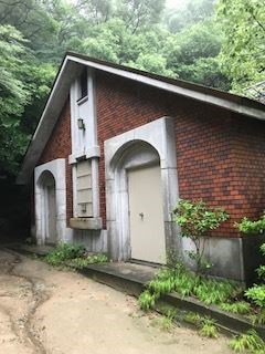
このアースキャッシュの公開座標のところにある下写真の建物の裏側にまわって、崖を観察してみましょう。
建物写真
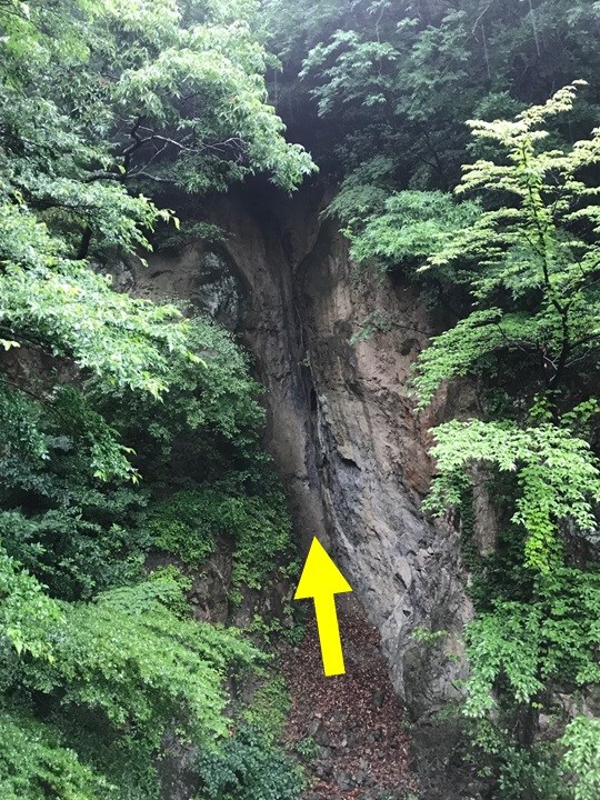
ここでは、下写真のように、布引断層が崖面に露出しているのを観察することができます。矢印で示した箇所が断層で、深く浸食されていることが観察されます。この断層は、硬い花崗岩が1mほどの幅で水を含む粘土となり、脆くなっています。これは、断層が動いたときの力によって、断層部分の岩石が割れたり潰されたりしたためです。このようなところを断層破砕帯と呼びます。断層破砕帯は、周囲の岩に比べて浸食に弱いという特徴があります。
布引断層写真
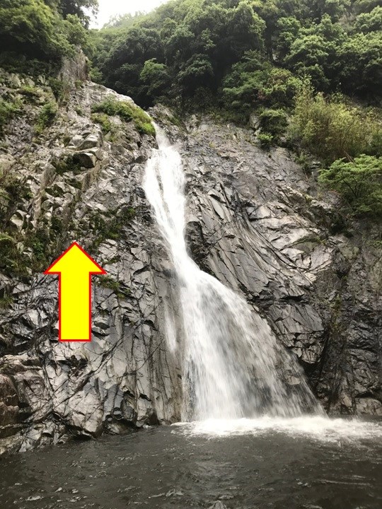
また、Additional Waypoint "Ontaki Fall"のところでは、下写真のような落差43mの雄滝を観察することができます。この雄滝は、滝の上流側が断層に沿って写真で矢印で示すように上昇したため、断層を横切って流れていた生田川が滝になったものです。
雄滝写真
[Task]
以下のクイズに対する回答をキャッシュオーナーに送ってください。
[Quiz 1]:公開座標において、崖と反対側を見てください(概ね南西方向です)。そこには貯水池があり、対岸へと布引断層が続いていると考えられています。布引断層が存在することに起因して、対岸の地形はどのようになっていますか?
[Quiz 2]:Additional Waypoint, "Reference Point for task"のところには橋が架かっています。この橋の上流と下流のところには、川の流れを横切るように断層が走っていると考えられています。この断層の存在によって、川の流れはどのように変化していますか?
[Quiz 3]:Quiz 1の回答のような地形や、Quiz 2の回答のような変化は、断層破砕帯どのような性質に起因して生じたものでしょうか?
[English descriptions begin from here]
In this Earth Cache, you will learn about the various topographies formed by Nunobiki fault.
What is a fault?
A fault is a state in which a stratum or bedrock cracks due to a crustal deformation force, thereby the both sides are displaced with each other along a cracked surface. Fault movement is thought to be a main cause of earthquakes. The Hanshin Awaji great earthquake that caused great damage in the vicinity of this earth cache is thought to have occurred because the Rokko-Awajishima fault zone was activated.
Observation of Nunobiki fault
Let's observe the cliff behind the building shown in the picture below at the published coordinates of this earth cache.
Here you can observe that Nunobikif fault is exposed on the cliff face as shown in the picture below. It is observed that the part indicated by the arrow is a fault and it is eroded deeply. In this fault, a hard granite has become a clay containing water with a width of about 1 m, and thus has become brittle. This is because the rocks in the fault part was cracked or crushed by the force when the fault moved. Such a part is called a "fault fracture zone". The fault fracture zone has characteristics that it is weaker against erosion than the surrounding rocks.
Also, at the Additional Waypoint "Ontaki Fall", you can observe Ontaki fall with the height of 43 meters as shown in the picture below. This Otaki fall is the one where the Ikuta River flowing across a fault has become a waterfall because the upstream side of the waterfall rose along the fault as indicated by the arrow in the picture.
[Task]
Please send to the cache owner your answers for the quizzes below.
[Quiz 1]: At the published coordinates, look at the opposite side of the cliff (it is generally in the southwest direction). There is a water reservoir there, and it is thought that Nunobiki fault continues to the opposite shore. What is the topography of the opposite shore due to the existence of Nunobiki fault?
[Quiz 2]: There is a bridge at Additional Waypoint, "Reference Point for task". It is thought that some fault run across the river flow in upstream and downstream of this bridge. How does the flow of the river change by the existence of such faults?
[Quiz 3]: By what nature of the fault fracture zone are the topography like Quiz 1's answer and the change like Quiz 2's answer caused?