This EarthCache is located within the Tosohatchee Wildlife Management Area. It is NOT accessible directly from the 528. The entrance to Wildlife Management Area is at N 28 29.902, W 80 59.915 where there is a small fee to enter the area at the self pay station. Thank you to the Florida Fish and Wildlife Conservation Commission for permission Permit GEO-49456. Visitors should be aware of seasonal hunting and must abide by all area regulations while on the area. Please visit http://myfwc.com/viewing/recreation/name/ for more information.
Welcome to beautiful Lake Charlie! This is an EarthCache, there is no physical container to find at the coordinates. To get your smiley for the cache, e-mail or message center your answers to the questions below to the cache owner.
Lakes are formed in several ways and are categorized as natural or man-made.
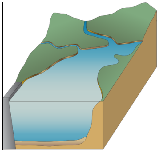
Man-made Lakes:
Man-made lakes, often called reservoirs or artificial lakes are made by people who have dug basins or dammed rivers or springs. They often have a tree shaped appearance, thin at one end, a narrow lake basin, and thicker deeper appearance toward the dam. Man-made lakes receive their water from runoff which is linked to rainfall. Due to this fact the water levels of man-made lakes change often.
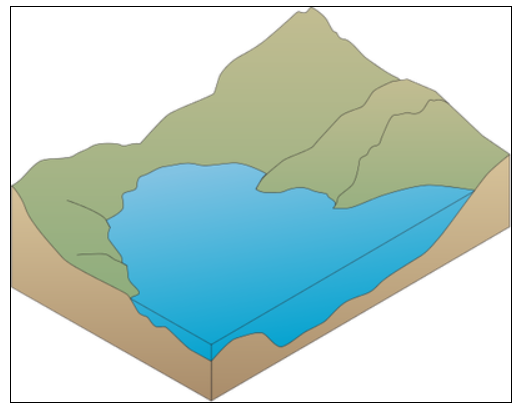
Natural Lakes:
Natural lakes have a rounded appearance due their formation being glacial, volcanic, or tectonic. They are usually deepest at the center of the basin. They tend to be located at the headwaters of rivers, streams or between mountains and their water levels remain fairly constant. Due to this fact natural lakes have a lower nutrient and sediment concentration compared to man-made lakes.
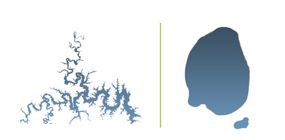
Shoreline:
The shape of a lake’s shoreline is an indication of what is happening under water. The more jagged a shoreline is, the more affected the lake is by the surrounding run off from the land as well as groundwater leaching. Mostly, lakes have a circular or rounded appearance, but some lakes can be highly irregular in shape.
Shoreline sediment in man-made lakes is often built up due to the fact of the fluctuating water levels. The change in water level prevents shoreline vegetation from growing and stabilizing the area around the lake edge. The frequent water level change also encourages nutrients such as nitrogen and phosphorus which help algae to grow in the lake. These algae can often be seen sunken on the floor of man-made lakes.
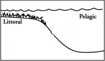
Lake Bed:
The material at the bottom of a lake is called the lake bed. Lake beds are composed of decomposed plants and animals that have sunk to the bottom and mixed with and sand or silt. Lake beds are classified into 2 main zones: Littoral and Pelagic.
Littoral zone: The shallow perimeter around a lake. This zone is shallow enough that sunlight can shine through it and reach the lake floor.
Pelagic zone: The open water of a lake. Usually darker in appearance and the bottom is not easily seen.
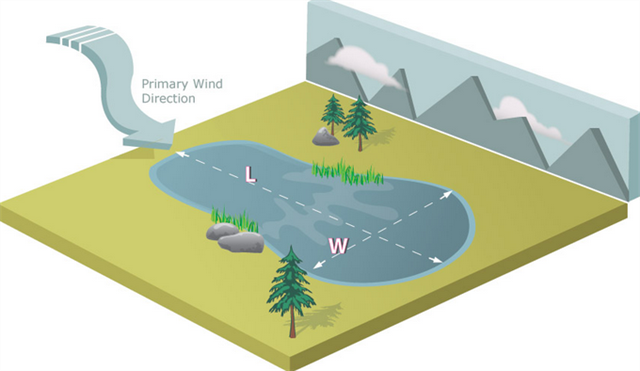
Primary Wind Direction:
Due to winds picking up speed over open water the primary wind direction of the area can determined due to the shape of the lake. Wind moves water, sediment, and debris from one end of the lake to the other. The smaller end of the lake often times is where the wind starts and the larger end is where the wind carries.
Now it is time for the questions. To get credit for the cache, please answer the questions below. When answering the questions, do your best. It is more important that you learn a new concept about our earth and can apply your knowledge, rather than have a precise answer.
Questions:
1- Describe the shape of the lake and how does this tell you if the lake is man-made or natural?
2- What type of sediment is in the Littoral zone?
3- At GZ what does the shoreline sediment tell you about the change in water level?
4- Noticing where the majority of the sand and silt are deposited at Lake Charile, what does that tell you about the primary wind direction?
Thank you for visiting this earthcache. Please send your answers to the above questions to the cache owner. In your "found it" log feel free to write about your experience, but don't include the earthcache answers. Thanks and we hope you enjoy beautiful Lake Charlie!
Sources:
https://en.wikipedia.org/wiki/Lake
http://www.lakescientist.com/lake-shape/
http://www.lmvp.org/Waterline/winter2003/dam.htm
https://www.nationalgeographic.org/encyclopedia/lake/
http://ian.umces.edu/imagelibrary/