|
![]()
Welcomes You To
Rock Around
The Queen Mary
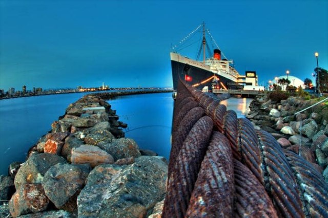
Built in the United Kingdom in the 1930s, the Queen Mary’s rich history includes the Great Depression, World War II, the heyday of transatlantic travel during the late 40’s and 50’s and the eventual decline of ocean liners in the 60’s. Relocated to Long Beach, California in 1967, the Queen Mary is a historic reminder of a bygone era. Reborn as a hotel and attraction, the Queen Mary has become a Southern California historic landmark, offering people an opportunity to step back in time and experience the grand days of ocean liner travel.
![]()
After her hospitable arrival in Long Beach, the Queen Mary patiently waited at Pier E to undergo conversions while in dry dock. In April of 1968, the liner went into Navy dry dock, where she commenced her conversion and renovation process. While at Pier E and in order to make way for the planned museum, the Queen Mary’s C Deck and lower decks were completely gutted. Her two turbo generator rooms, forward engine room and five boiler rooms were completely stripped of their machinery. Only the steering gear and aft engine room’s equipment remained. On February 27, 1971, the ship was relocated from Pier E to its everlasting home at Pier J.
![]()
Shortly after The Queen Mary was moved to Pier J, a breakwater was installed around the ship built out of large boulders. The rock breakwater is built like a pyramid, with the widest part touching the ocean floor. The rocks stick up only a few feet above the water but do an excellent job of stopping the waves. The breakwater project required a large source of rock. Santa Catalina had a proven source of rock on the east end of the island from a quarry called Pebbly Beach Quarry. It was realized that a rock source on the ocean would provide a tremendous transportation advantage. There being no known sources on the mainland in protected waters in Southern California, Catalina Island was the best option.
![]()
Geologically speaking, Catalina Island is quite young. Its oldest geologic formations are a little more than 100 million years old. There are basically three broadly identified and locally complex types of rock that make up Catalina Island. While that sounds like an immense span of time, it is barely 2 percent of the entire age of the Earth. Catalina Island's youngest formations were formed in the past 5 to 20 million years, and the Island itself has been above the surface of the ocean for just the last few million years or so. But this span of time still encompasses the end of the Cretaceous Period (the end of the age of the dinosaurs) and the rise of the age of mammals in the Tertiary Period.
![]()
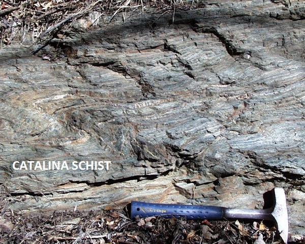
The basic story of how the island was formed, and the rocks you see around you were deposited, was assessed by Stephen Rowland in a 1984 summary paper: "...the geology of Santa Catalina Island consists of a Mesozoic metamorphic basement complex intruded and overlain by Miocene igneous rocks...[with] a few scattered deposits of Tertiary sedimentary rocks..." What this somewhat puzzling sentence is saying is that there are basically three broadly identified and locally complex types of rock that make up Catalina Island.
![]()
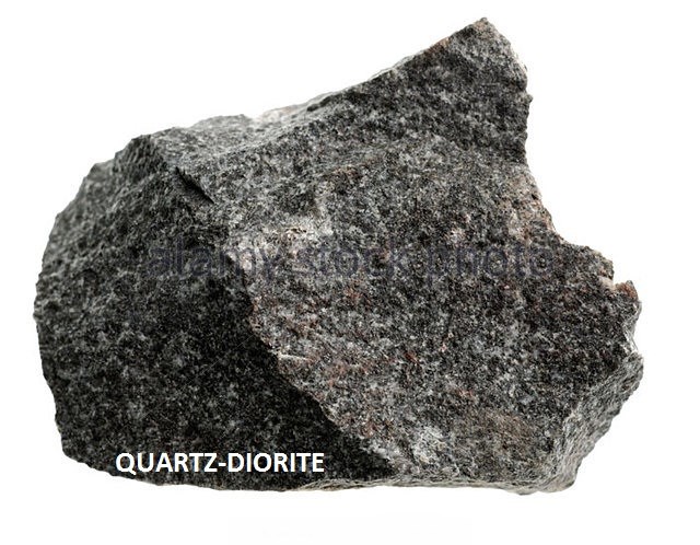
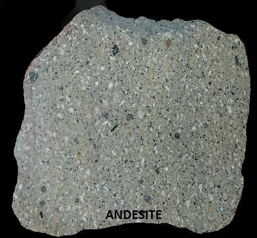
The first type is the Catalina schist, which is exposed throughout the western and central parts of the Island. This is the "Mesozoic metamorphic basement complex”. The second type is the quartz diorite of the Catalina Pluton, exposed on the East End and reaching Middle Canyon. This is the "intruded Miocene igneous" rock. And finally, there are the various andesite rocks that form an exposure that nearly bisects the center of the Island from the channel shore to the windward side from White's Landing to Mount Banning. These are the "overlain Miocene-aged volcanic rocks" that Rowland describes.
![]()
To log a find on this cache, you must E-MAIL me the correct answers. If any of your answers are wrong, I will email you and let you know. If you haven't heard back from me in a day, that means your answers are correct.
![]()
1. Put "Rock Around The Queen Mary" in the subject line of your email.
![]()
2. Of the three types of rock mentioned above, which one are the majority of the rocks at GZ?
![]()
3. What part of Catalina Island did they come from?
![]()
4. At the posted coordinates, describe to me what is below your feet?
![]()
5. Color? Texture? Size?
![]()
6. Post a picture of you at the posted coordinates.
![]()
Works Cited
https://www.catalinaconservancy.org/index.php?s=news&p=article_322
![]()
https://www.scec.org/publication/875
![]()
http://ryono.net/malpha/transversepeninsular/transverse.html
![]()
https://www.haikudeck.com/igneous-rocks-education-presentation-71cxUh1hTP
![]()
http://www.alamy.com/stock-photo/diorite-rock-sample.html
![]()
|