Redmond Rain #26 - When the River is Low Traditional Cache
Redmond Rain #26 - When the River is Low
-
Difficulty:
-

-
Terrain:
-

Size:  (micro)
Please note Use of geocaching.com services is subject to the terms and conditions
in our disclaimer.
Redmond Rain . . . will fill the floodplain
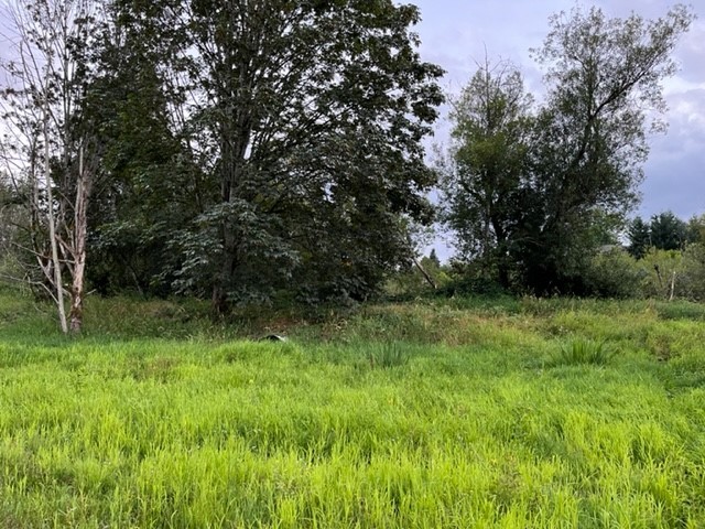
Approach from west side of river. When the river is very low you can walk to it. When it is high, you will need a plan. The time to get this cache is in the heat of summer when things have dried out. Be ready for tall grass and thorns. In the winter, the terrain rating goes quickly to 5.
FTF: Valkarie63
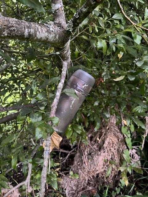
Find the trailhead where the grass grows wide between the trees. King County mows this from time to time, typically in late summer to improve river flows in the winter, making for an easy walking experience. Without their assistance, you'll need to cut your own trail down to the floodplain, possibly through acres of thorns. Unfortunately for the hide, King County sometimes cuts down the trees, too. Plus the river is pretty hard on trees growing out here in the channel. Below is a picture of the container as it was most recently placed. Good luck!
Your Container
Looking West from GZ
Willowmoor Floodplain Restoration Project
The King County Flood Control District and the City of Redmond are partnering to improve the flood plain downstream of the Sammamish River Weir. The project proposes to reconfigure the Sammamish River Transition Zone, which is at River Mile 13.0-13.5 of the Sammamish River in Marymoor Park. The project area includes the river channel and adjacent undeveloped land to the southwest of the river channel.
Overview
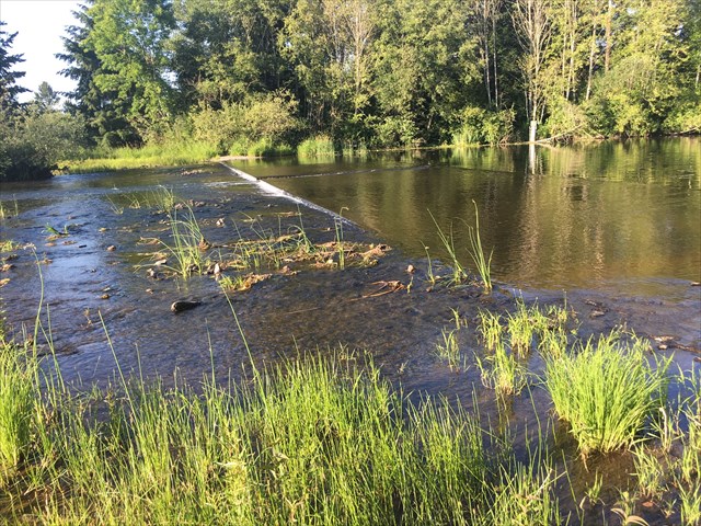
In the mid-1960s, the U.S. Army Corps of Engineers constructed the Sammamish River Flood Control Project – an almost 14-mile long project from Lake Sammamish to Lake Washington to provide flood protection to the Sammamish River valley. The project effectively lowered the bottom of the Sammamish River by over 6-feet. The Transition Zone, a key component of this project, is essentially a ramp near the Lake Sammamish outlet that connects the old river channel to the deepened river channel downstream. This straight, rock-armored channel is approximately 200 feet wide and drops over six feet along its 1,500 foot length. During low to moderate lake levels, lake outflow is contained within a 30-foot wide low-flow channel running down the center of the Transition Zone. Ten-foot wide willow buffers line both banks of this low flow channel. During higher lake levels, lake outflow occupies the entire width of the Transition Zone. At the upstream end of the Transition Zone, a concrete weir controls lake outflow maintaining minimum summer lake levels. A narrow notch in the middle of the weir provides both up and downstream passage for Chinook salmon and other fish species, and allows downstream passage for small boats such as canoes and kayaks. During high lake outflows, flow control shifts from the weir to the Transition Zone. King County crews annually maintain the Transition Zone, including trimming the willow buffer and mowing the grass. Though currently required, these maintenance practices harm habitat and water quality and conflict with federal, state and local goals to protect ecological functions and species listed under the Endangered Species Act. Overall, these efforts, known as the Sammamish River Flood Control Project, have been very successful in limiting flooding in the Sammamish River Valley. However, its construction and corresponding development has drastically impacted habitat conditions in the river channel and adjacent floodplains. In the vicinity of the Transition Zone, the poor physical habitat conditions are compounded during the summer by higher temperature water from the Lake Sammamish outflow that is harmful to salmon. Learn more and follow the project here.
If you come when the river is low, take some time to wander up the transition zone to the weir. I think it is pretty cool.
Lake Sammamish Weir
Additional Hints
(Decrypt)
Gur pbagnvare vf unatvat sebz n jvyybj gerr va gur zvqqyr bs gur punaary. Vg vf n gurezbsynfx, fb cerggl tbbq fvmr, ohg gur gerrf ner nyjnlf tebjvat naq gur evire vf nyjnlf punatvat.
Treasures
You'll collect a digital Treasure from one of these collections when you find and log this geocache:

Loading Treasures