Hinchinbrook Island
Hinchinbrook Island is a continental high island; an outcrop of continental rocks and regolith that was isolated from the mainland coast during the post-glacial transgression. Hinchinbrook is composed of 260 million year old Almaden Granites with significant variation in composition across the island. The granite of the main mountain mass featuring Mount Bowen (1142m), Mount Diamantina (955m) and Mount Straloch (922m), has weathered to spectacular, jagged peaks. The island is separated from the mainland by the narrow Hinchinbrook Channel, which represents the flooded former valley of the Herbert River.
At Ramsay Bay on the northeast coast, a transgressive dune barrier, or "tombolo" links Cape Sandwich, an outlying group of granite peaks at the north eastern tip of the island, to the main body of the island. This dune barrier consists mainly of aeolian sands and extends more than 30 metres below the present sea level in places. The dune barrier is thought to have been formed in two major episodes, the older dunes being partly drowned during an early Holocene marine transgression;(9500-6000 C-14 years BP) with the later generation of dunes forming within the last 900 C-14 years. The sheltered side of these dunes supports an extensive mangrove and salt flat area on colluvial and alluvial deposits, with numerous deep channels.
Longshore drift is a geological process whereby sediment (clay, silt, sand and shingle) is transported along a coast parallel to the shoreline. The direction of sediment travel is dependent on the wind and wave direction. Oblique incoming wind squeezes water along the coast, and generates a water current which moves parallel to the coast. Longshore drift is simply the sediment moved by the longshore current. This current and sediment movement occurs within the surf zone.

Beach sand is also moved, due to the swash and backwash of water on the beach. Breaking waves sends water up the beach (swash) at an oblique angle. Gravity then drains the water straight downslope (backwash) perpendicular to the shoreline. Thus beach sand can move down beach in a zigzag fashion. This process is technically called "beach drift", but is usually considered to be simply a part of "longshore drift" because of the overall movement of material parallel to the coast.
What is a tombolo?
A tombolo, from the Italian tombolo, derived from the Latin tumulus, meaning mound, is a deposition landform in which an outlying island becomes attached to the adjoining land. Tombolos are formed in two common ways:
1. Wave Refraction and Diffraction
As waves approach an offshore island, the waves are slowed by the shallower water and bend around the island. The wave pattern created by this water movement causes a convergence of longshore drift and accretion of material on the leeward side of the island. Similarly, on the nearby beach, the wave energy and longshore drift are reduced in the lee of the island and deposition of sand occurs, forming a spit. When enough sediment has built up, the spit on the beach shoreline will connect with the island and form a tombolo. Hinchinbrook Island has an example of this sort of tombolo at Hillock Point, the most easterly point of the Island.

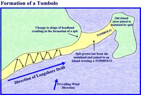
2. Longshore drift
Where there is longshore drift from a dominant direction, the flow of material is along the coast. At the end of the island, a spit will develop in the dominant direction. This spit will extend until it connects to the adjacent island, tying this island.
Claiming this Earthcache
To claim this Earthcache as "Found", please contact me using the “message this owner” link at the top of the page, with your answers to the following items:
Ramsay Bay beach - Waypoint 1
- Observe the dunes along the length of the beach. Make note of relative elevations of the dunes at either end of the beach.
Summit of Nina Peak - Listed Coordinates
- Look to the north and observe the sand dunes along the length of the Ramsay beach. Pay attention to the tombolo dunes, not the mangrove area. Describe your observations. Where are the dunes the widest? Why do you think this is?
- Referencing your observations at both waypoints, describe the geological process that has formed this dune.
- Based on your observations, and the geological process, hypothesize about the predominant weather direction ?
- Look to the southeast along the Hinchinbrook Island eastern coast over Nina Bay, Little Ramsay Bay, Banksia Beach and Agnes Beach. At the most easterly visible point, just offshore there is a rocky Island, Agnes Island. With reference to your knowledge about the formation of tombolos, describe your observations of the western shore of Agnes Island and adjacent eastern shore of Hinchinbrook island. What is the geological process taking place here?
- Optional (but highly appreciated) – in your online log, attach photos of yourself taken on your journey.
Some Guidance
The cache is located in Hinchinbrook Island National Park and your journey to claim this cache will follow the northern portion of the famous Thorsborne Trail on the east coast of the island. I would recommend completing the full Thorsborne Trail over a minimum of 3 or even 4 nights if you are able.
All applicable NPWS rules and regulations must be complied with at all times. Please check the NPWS website Park Alerts web page before setting out. To access the cache, you will need either a boat or a sea kayak to make your way to Waypoint 1, which is strategically located near the boardwalk providing access from a large creek in Missionary Bay.
Having made your observations at Waypoint 1, walk south to the headland at the southern end of Ramsay Bay, where the Thorsborne Trailhead is marked with an orange marker to the right of a large obvious granite boulder. The trail climbs over a low ridge behind the headland before descending to the middle of Blacksand Beach behind a small lagoon. From here, the trail passes through tall open forest and climbs steadily to a saddle below Nina Peak (Waypoint 2).
Leave the Thorsborne trail here and climb south west up Nina Peak on a rough rocky steep trail. The trail is non-existent in places where it crosses large granite slabs. Continue up past the false peak on to the listed coordinates at the summit of Nina Peak. Please take care around the cliff edges at the summit.
Please take the usual precautions for a hike of this nature, practise minimal impact bushwalking and stay safe. You should pack a topographic map, compass, first aid kit, PLB, food, water, sunscreen, insect repellant, some warm clothes and wet weather gear. There is very limited mobile phone coverage which cannot be relied up at Nina Peak (using Telstra). You must obtain a permit from QNPWS if planning to camp overnight or hike the Thorsborne Trail
References:
https://en.wikipedia.org/wiki/Hinchinbrook_Island [27 July, 2017]
https://en.wikipedia.org/wiki/Tombolo [27 July, 2017]
https://openresearch-repository.anu.edu.au/bitstream/1885/115032/2/b1317910x.pdf [27 April, 2017]