This earthcache is located at the end of Bishop Mountain Road. Parking is available at the end of the road at certain times of the year. The road is in fair shape in the summer months but is not maintained in the winter. It will be a 1.3 km hike from the beginning of the road or a 100 meter walk if you drive to the bottom where there is a turn-around spot. We took a suv down and had no problems.
There is a parking place if you don’t want to go down the hill to the turn-around area. Check tide times before you go or you may not be able to make it to the sea cave and be careful on the wet rocks.
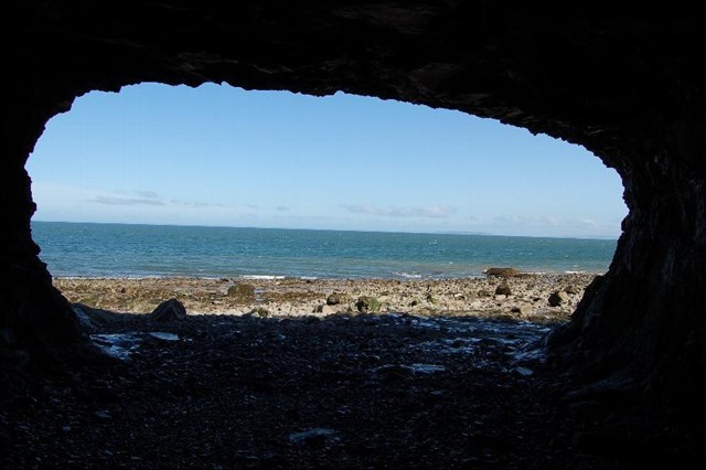
An adit is located west of where Conner brook flows into the Bay of Fundy. This adit (a horizontal passage leading into a mine for the purposes of access or drainage) is quite noticeable. It is said that copper mining was done in this area in the past. It looks like they were following a vein of some kind. Walking west towards Margaretsville, is the sea cave approx 60 meters past the adit and it is a pretty impressive sight. You can find drill holes in the rocks if you look all around this area.
Several hundred million years ago (Jurassic), volcanic eruptions along a fault line poured out lava, forming a ridge of basalt which today is known as the North Mountain Range. It is usually just referred to as the North Mountain and rises dramatically from the valley floor and tapers somewhat more gradually to the north and west where it meets the coast. Many parts of this coast and have vertical cliffs rising higher than 30 metres creating dramatic cliffs and headlands. The vesicular tops of these flows created the ideal setting for the formation of the mineral crystals such as zeolites, amethyst and agates.
The term igneous comes from the Latin ignis, meaning "fire". Igneous is used to describe rocks that crystallize out of hot molten material in the Earth called magma. When magma pushes up through Earth's crust to the surface, it is called lava. Both magma and lava cool and harden to form igneous rocks. Igneous rocks can be classified into two main categories: intrusive and extrusive. A trick to help kids remember intrusive and extrusive is to think of intrusive -- inside and extrusive -- exit.
Extrusive igneous rocks come from lava. Lava, at the surface, is exposed to air and water which causes the molten rock to cool rapidly. Solidifying rocks at the surface cool too quickly for large crystals to form. Molecules in the lava do not have time to arrange themselves to form large crystals. Extrusive rocks have crystals that are too small to see without magnification. A common example of an extrusive igneous rock is basalt. Some extrusive rocks, such as obsidian and pumice, cool so rapidly that they completely lack crystal structure and are considered a volcanic glass. Pumice is just like obsidian except it is tiny shards of glass.
Sea caves are formed by the forces of the sea waves pounding up on the coast line. Caves are usually just as deep as the water waves can reach. The weaker the rock formation like where a fault line is located is a likely place for a sea cave to be created.
All of the largest sea caves are in basalt a relatively strong host rock compared to sedimentary rock. Basaltic caves can penetrate far into cliffs where most of the surface erodes relatively slowly
It is not necessary to go in the sea cave to obtain the answers if you do not wish to go inside. That will be your choice. Be care along the shore as it is slippery and can easily fall.
I found on this note on the internet ……2014 if you keep going west for a bit you will come across a huge mound of crumbled cliff and boulders with some small evergreens growing on top .Theres a small,about 60 feet long,talus cave that twists around ,accessed from top of pile by trees. If anyone wants to venture further. I have not checked it out myself.
https://www.youtube.com/watch?v=S06_wa3il5c
Must be done at half to low tide, it is Bay of Fundy so watch tide it moves fast
To log this Earthcache visit the viewing location. Please answer the following questions and send in a timely manner to my geocaching profile or email. Answers not received will result in deleted logs.
1. How tall are the cliffs at the site of the sea cave?
2. What are the dimensions of the sea cave inside?
3. What is the rock formation in front of the sea cave?
A. Small and pebbly?.
B. Large jagged rocks?
C. Or flat lava flows?
4. In this area of the seacave would it be intrusive or extrusive or a combination of both?
5. What are 4 actions that would cause the formation of the sea cave?
6. [REQUIRED] In accordance with the updated guidelines from Geocaching Headquarters published in June 2019, photos are now an acceptable logging requirement and WILL BE REQUIRED TO LOG THIS CACHE. Please provide a photo of yourself or a personal item at the outcrop to prove you visited the site.