Important Note
This cache can only be done during the summer months. Don't try to log it with snow cover as you won't be able to see the geology.
Introduction
At the given coordinates the ground is covered with thousands of fairly big rocks, most of which are flat and elongated. It looks like they were dropped on this mountain top by a gigantic excavator, or a superhero smashed into the mountain. This EarthCache will explain how they came to be here.
General
The top of this mountain is littered with stones. How did they come here? Being above the Arctic circle with active glaciers down in the valleys the first answer that comes to mind is that they were transported by glaciers and dumped here. The process might have been similar to the terminal moraine with the fossil finds on the way up. However, glaciers are usually found in valleys and if you look around you'll find that you are on a plateau high above the glacial valleys.
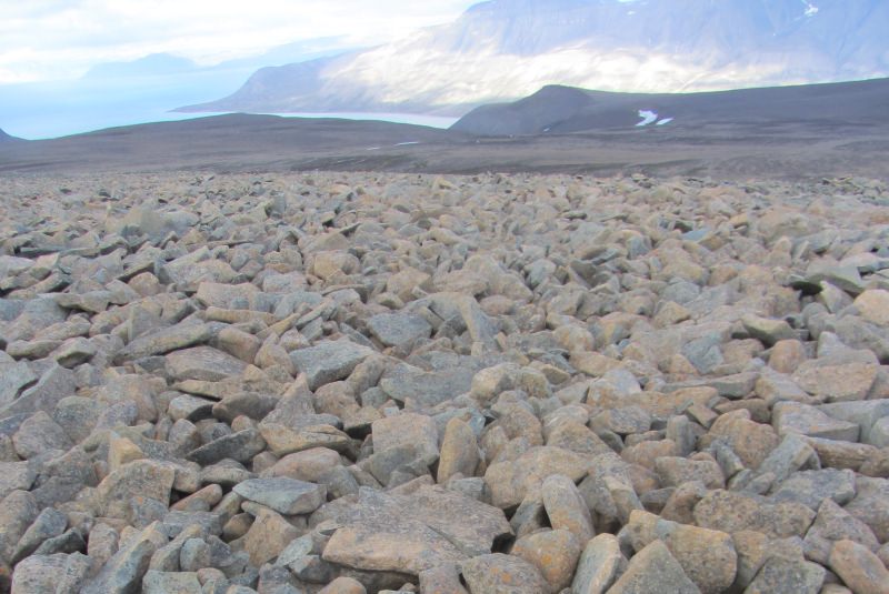
A sea of rocks
The most likely explanation for the presence of these rocks is that this is a blockfield, commonly known as felsenmeer (German: sea of rocks). A blockfield is a typical geological feature in alpine or polar regions and is characterized by a surface covered by large angular rocks. The rocks are usually of comparable size and sit on a relatively flat surface. If the surface slope was too big the rocks would eventually be transported downwards by water and gravity: bigger rocks need a steeper angle and faster flowing water to be moved while smaller rocks only need a gentle slope and less rapid water.
Origin
Blockfields are formed by water seeping into cracks in the bedrock. When this water freezes it expands and exerts pressure on the surrounding rock. After many freeze-thaw cycles the bedrock breaks into large, angular blocks. This is repeated many time during the arctic summer, and eventually the rock breaks into smaller pieces.
The soil is only thinly developed here and plant cover in summer sparse. Still this is sufficient to help in the breakdown of the bedrock as soil traps water that would otherwise run off the plateau. Furthermore, plant roots might grow into small cracks within the bedrock and leach minerals from it, effectively weakening these areas.
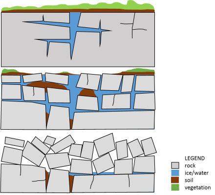
Once the bedrock is broken up the blocks are often tilted upwards. Remember that water expands when it freezes. Bits of soil and water creep underneath the newly formed blocks where they freeze and form an ice lens, a small local elevation that can tilt the blocks upwards over many cycles of freezing and thawing. While this happens, soil and smaller rock pieces are removed by wind and water. Eventually, vegetation becomes less due to less soil and the upright blocks that block sunlight. With less vegetation in place more soil gets removed until only the blocks remain. The removal of soil and smaller pieces of rock is called deflation. In the end, only the biggest blocks remain.
Logging tasks
In order to log this cache you will need to walk around on this plateau and look at different areas of your own choice, then send the answers to me. I have added a second waypoint that might be worth looking at for question three, but you can choose any you like.
1. At the fossil hunting site down in the valley you find some rocks with dark layers and different shades of grey which gives them a dirty appearance while others look 'clean' and are just of one grey. This is because the glacier collected rocks from all over the place and dumped them there.
If this sea of rocks was a glacial deposit all the rocks would be different. Look at the rocks here. Do they look the same or not?
2. At the given coordinates you can see large rocks littering the surface.
a. Describe their size and shape.
b. Do the rocks lay flat on the surface or are they jumbled up?
c. Also look at the slope angle of the plateau at this location.
3. Go further down the slope, look for another location with many rocks and do the same as for question2.
a. Are the rocks of the same size or overall bigger or smaller?
b. Is the slope here flatter or steeper?
c. You are at a lower elevation. Do you think there are more or less freeze-thaw-cycles here?
d. Speculate why the size of the rocks might differ. The text above and the questions 2c. might give you some ideas.
4. Find a location with lots of vegetation and enjoy the different plants growing there. Do you see as many rocks around as previously? If not: where are they? Think of deflation.
Hints, Tips and the Rest
Don't try to come here without a guide and/or a rifle due to polar bears. Wear proper clothing and boots. It can be very windy and cold at the top
I'm happy with answers in Norwegian, English, German and Dutch.
References
http://www.swisseduc.ch/glaciers/svalbard/permafrost/index-en.htm