This Earthcache is part of a series created by the Arkansas Geological Survey to help increase general knowledge of our state's geology. There is no physical cache located at the posted coordinates. To receive credit for the find, you will need to answer the questions in the description and email those answers to us through geocaching.com. Please do not post your answers in your log, but do feel free to post pictures at the Earthcache site as long as they do not give away the answers. We also ask that you practice the principles of Leave No Trace while caching. Let’s keep it fun for everyone for years to come!
Pinnacle Mountain Visitor Center Overlook Earthcache
GENERAL INFORMATION ABOUT PINNACLE MOUNTAIN STATE PARK
Pinnacle Mountain State Park (PMSP) was established in 1977 as a day-use park dedicated to environmental education, recreation, and preservation of green open spaces. Located just west of the city of Little Rock, the 2000-acre park contains a Visitors Center, ten hiking trails, an arboretum, and river access to the Little Maumelle River. The park is a popular location for picnicking, hiking, canoeing, and star gazing.
Standing at 1,011 feet above sea level, Pinnacle Mountain is the dominant landmark at PMSP. For generations, determined hikers have climbed to the summit in search of breathtaking panoramic views of the Arkansas River and the Ouachita Mountains.
GEOLOGY OF THE PARK
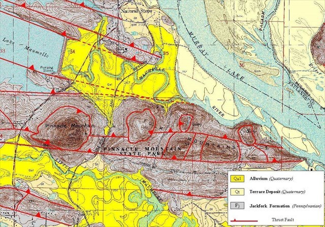
PMSP is located in the Ouachita Mountain Physiographic Province of central Arkansas. (Figure 1). Physiographic Province is a term used to describe a region that is made up of similar geologic features.

Figure 1. Physiographic Provinces of Arkansas. Red dot indicates relative location of PMSP in the Ouachita Mountains.
The primary geologic formation in the park is the Pennsylvanian Jackfork Formation (approximately 315 mya). Sandstone and shale are the two main rock types that make up the Jackfork. Sandstone is a rock composed of grains of quartz sand (SiO2). Shale is a thin rock made up of very small grains of clay and mud. Since shale breaks down relatively quickly, it forms gentle slopes, usually covered by vegetation. On the opposite side of the quarry lake, near the Visitor Center, you will notice a section of shale that can be compared to the sandstone that this overlook is built on. Sandstone is more resistant to erosion, and therefore forms the ridges found in PMSP.
The Jackfork is generally divided into lower and upper sections and is a maximum of about 6,500 ft (1,982 m) thick in Arkansas. At PMSP, the Jackfork is up to 1,300 ft (396 m) thick. The lower Jackfork consists primarily of dark gray shale with thinner intervals of sandstone; the upper Jackfork is dominated by thick intervals of sandstone with thinner intervals of shale (Figure 2).
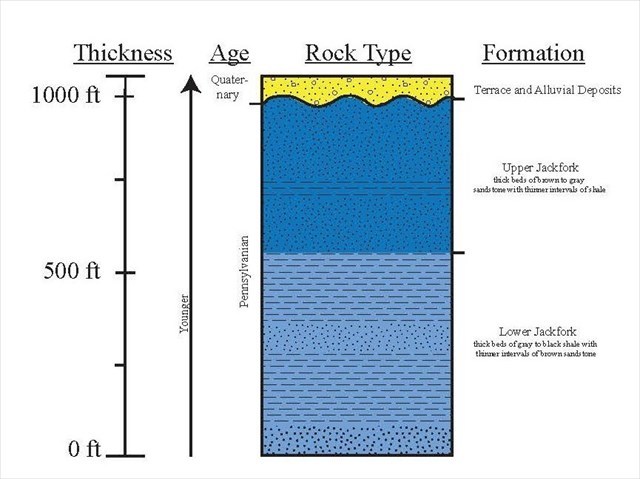
Figure 2. Stratigraphic column of geologic units of PMSP.
The Ouachita Mountains were formed during the Ouachita Orogeny as the South American tectonic plate collided with the North American plate, closing a marine basin that was present where southern Arkansas is today. (Figure 3).
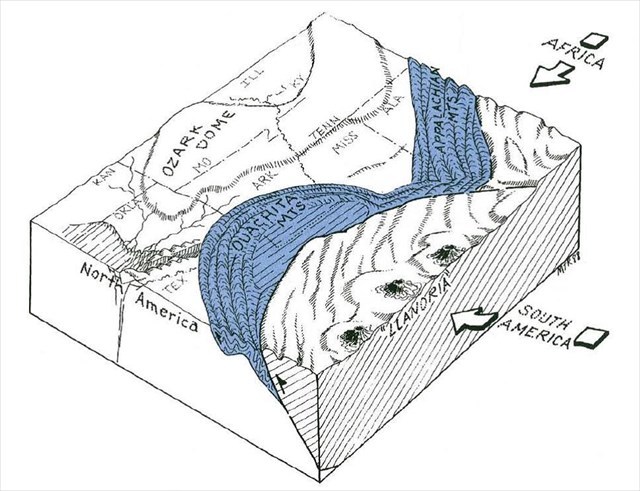
Figure 3. Conceptual sketch of the Ouachita Mountain Region near the end of the Ouachita Orogeny. (Guccione, 1993).
Thick layers of sedimentary rock deposited in this basin over millions of years were squeezed by the collision into the tightly folded and faulted layers of rock that we now see in the Ouachita Mountains. (Figure 4).
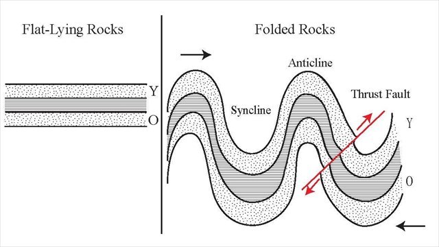
Figure 4. This figure shows the changes in flat-lying rocks due to compressional forces. Compressional forces are represented by the black arrows. The red arrows and line indicate a thrust fault and direction of movement on either side of the fault. The tight folding in this illustration is similar to that found in the Ouachita Mountains.
This intense compression caused a complicated network of thrust faults which resulted in older layers of rock being pushed over the top of younger layers, sometimes completely obscuring the original fold. PMSP is such an area, with up-thrown blocks of older sandstone resting beside and above younger blocks of sandstone. Pinnacle Mountain is believed to be the faulted remains of a tightly folded and possibly overturned syncline, but it is difficult to be completely sure. The chaotic nature of the thrust faulted blocks has dramatically changed the original rock layer’s orientation, and makes interpretation tricky. (Figure 5).
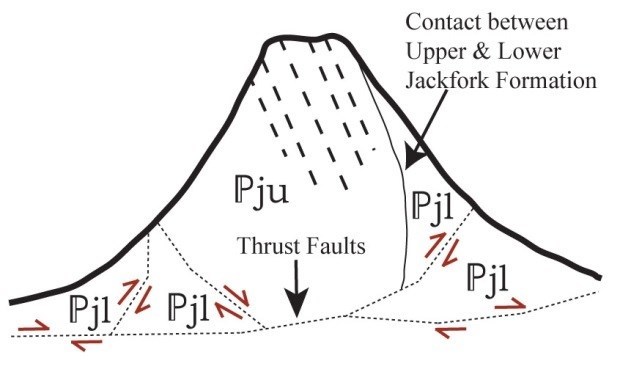
Figure 5. Figure interpreting that Pinnacle is not a single layer of rock, but thrust-faulted blocks of Upper & Lower Jackfork.
Three rivers run through the general area of PMSP; the Arkansas, Little Maumelle, and Maumelle Rivers. These rivers are responsible for recent deposits of unconsolidated sands and gravels in PMSP.
Questions:
1. As you walked up to this location from the parking lot, you passed the sandstone outcrop that this overlook is built on. Looking at this outcrop, which direction are the rocks tilted? What might that tell you about the direction of compressional forces acting on this rock?
2. Looking west from this location, just to the left of the visitor center parking lot you will see an abandoned quarry pond. What type of rock do you think was being quarried here? Why do you think this?
3. On the hillside across the quarry pond from this location you can see two different rock types. Light brown sandstone, and dark gray shale. Compare the hillsides populated by both types of rock. What are your observations of differences/similarities?
References:
Guccione, M.J., 1993, http://www.geology.ar.gov/pdf/Geologic%20History%20of%20Arkansas%20Through%20Time%20and%20Space%20Color%20Copy.pdf
Haley, B. R., et al., 2003, Geologic Map of the Pinnacle Mountain Quadrangle, Pulaski County, Arkansas: Arkansas Geological Commission Open File Report, scale 1:24,000.
Jordan, D.W., et al., 1991, Scales of Geological Heterogeneity of Pennsylvanian Jackfork Group, Ouachita Mountains, Arkansas: Applications to Field Development and Exploration for Deep-water Sandstones: AAPG field trip guidebook, Dallas Geological Society/Arkansas Geological Commission Guidebook 93-1, 142 p.
Morris, R. C., 1971, Stratigraphy and Sedimentology of Jackfork Group, Arkansas, The American Association of Petroleum Geologists Bulletin v. 55, No. 3, p. 387-402.
Smart, E., et al., in prep, The Geologic Story of Pinnacle Mountain State Park, Arkansas Geological Survey State Park Series 05.
Congrats to ronwhite&mona on the FTF!